Earth ChangesS


Dollar

More Pusillanimous Propaganda: Scientists connect global warming to extreme rain

Image
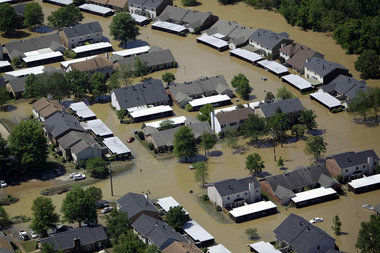
© Mark Humphrey, Associated PressThis flooded neighborhood in Nashville, Tenn. was photographed May 3, 2010.
Extreme rainstorms and snowfalls have grown substantially stronger, two studies suggest, with scientists for the first time finding the telltale fingerprints of man-made global warming on downpours that often cause deadly flooding.

Two studies in Wednesday's issue of the journal Nature link heavy rains to increases in greenhouse gases more than ever before.

One group of researchers looked at the strongest rain and snow events of each year from 1951 to 1999 in the Northern Hemisphere and found that the more recent storms were 7 percent wetter. That may not sound like much, but it adds up to be a substantial increase, said the report from a team of researchers from Canada and Scotland.

Radar

US: Strong storm activity is expected through weekend

Southern California drivers slogged through a wet, slow Friday evening commute as the first of two bands of heavy rain moved through the region.

The National Weather Service said the storm could bring heavy snow to the mountains, the potential for funnel clouds along the coast, lightning and 70-mph wind gusts in mountain passes.

Officials said the region can expect strong storm activity through Saturday morning, then scattered showers followed by heavier rains Saturday night.

Numerous accidents were reported on freeways in the region, according to the California Highway Patrol. In San Pedro, the Coast Guard and Los Angeles Fire Department rescued a man whose sailboat smashed into rocks.

In the Sierra Nevada, Lake Tahoe resorts reported up to 4 feet of snow over the last 24 hours. Chains were required on many local mountain roads, where several accidents blocking roads were reported.
"A strong front will bring a four- to seven-hour period of heavy rain this afternoon into tonight," the weather service said in a statement. "Numerous showers will continue across the region through Saturday night. There will be a chance of thunderstorms at anytime from this afternoon through Saturday night."

A flash-flood watch has been issued for mountain areas that have been scorched by wildfires in recent years.

The heaviest rainfall was expected to hit Santa Barbara and Ventura counties Friday afternoon and reach the Los Angeles area in the late afternoon and last until about midnight, the weather service said.

The flash-flood watch was issued for areas that were burned by blazes such as the Station and Morris fires in the San Gabriel Mountains in 2009, the weather service said.

Those areas "will have the potential for flash flooding and debris flows," the agency said.

Snowman

US: Northeast Arizona: Winter Weather Advisory in effect; significant storm approaching

A winter weather advisory remains in effect until 5 pm mst Sunday.

Timing: snow showers will increase across the higher elevations later today with lowering snow levels and periods of heavy snow tonight. Lighter snow is expected Sunday.

Snow levels: around 8000 feet today, lowering to 6000 feet this evening, then lowering to around 5000 feet Sunday.

Snow accumulations: 8 to 12 inches of snow is likely above 8000 feet, with 4 to 10 inches between 6500 and 8000 feet elevation. High mountain areas will have the potential for even greater amounts.

Travel conditions: dangerous winter driving conditions are anticipated with blowing snow and poor visibility.

Precautionary/preparedness actions: a winter weather advisory for snow means that periods of falling snow will cause travel difficulties. Be prepared for slippery roads and limited visibilities. Plan extra time for travel.

For the latest road conditions and closures call the ADOT freeway management system at 1-888-411-7623 or visit their website.

Cloud Lightning

US: Storm reaches southern California; flash-flood watch issued

Image
© Nick Ut/APHeavy rains in the forecast for Southern California through the weekend.
A powerful winter storm dumped about a half-inch of rain on Los Angeles and forecasters say more wet, messy weather is expected.

The National Weather Service says another mass of cold air moving into Southern California could bring thunderstorms Saturday afternoon and into Sunday.

This latest storm could drop up to four inches of snow at elevations as low as 3,500 feet, causing potential traffic snarls on mountain passes.

Rain began to move into the region from the north Friday afternoon and made a mess of the evening commute. The California Highway Patrol says there were approximately 158 collisions between 3 p.m. and 7 p.m. Friday, compared with 80 for the same time period one week ago.

A flash-flood watch was issued for mountain areas that have been scorched by wildfires in recent years, but there are no immediate reports of any problems.

Bizarro Earth

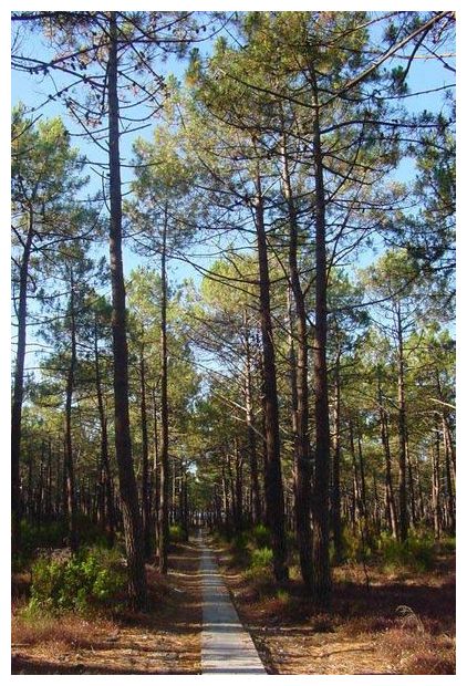
US: Mysterious Outbreak Killing Pines in Montana

Pine Trees
© Patrick Verdier / Wikipedia
Salmon, Idaho - Bob Appleby will learn this spring if the evergreen tree in his yard in Montana has survived a mysterious outbreak threatening to kill thousands of Austrian pines across the state.

"It was a real pretty tree; we just want it to stay alive," the Bozeman, Montana man said about a towering Austrian pine cropped to 15 feet to stem the onslaught of what scientists say is an ailment of unknown origins happening in epidemic proportions.

Although native to Europe, the tree has gained extensive ground in Idaho, Montana and Wyoming, where the pine's dense needles, uniform shape and tolerance of tough conditions have made it a popular planting in downtowns, parks and private properties.

In a trend experts say has emerged in recent months, the tree's top branches brown and die at the start of what appears to be a march down the trunk despite preventative pruning.

"As we go through winter, these trees are continuing to die; it's one big laboratory out there," said Linnea Skoglund, plant disease expert with Montana State University.

Skoglund said the school's Schutter Diagnostic Lab has been flooded with calls from city foresters, tree surgeons and landscapers, all alarmed by the sudden decline of Austrian pines.
Bell

Natural disasters have tripled in Germany since 1970: Munich Reinsurance Co.

Image
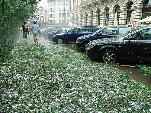
After a Hail Storm, Leipzig, Germany (16th of June 2006)
German insurers' losses from natural catastrophes are rising as global climate change causes more inundations and storms, Munich Reinsurance Co. said.

Weather-related events have more than tripled in the country over the past 40 years, Peter Hoeppe, who heads the Munich-based reinsurer's Geo Risks Research Department, told journalists in Dusseldorf, Germany, on Thursday. A rising trend is also measurable worldwide, he said.

Insurers' claims costs related to natural disasters rose last year. Allianz S.E., Europe's biggest insurer, recorded "high losses from natural catastrophes and bad weather conditions" in the three months ended September 2010, it said in the quarterly report on its website. Flooding, windstorms and a hailstorm cost the firm about €137 million ($186 million) in Germany in the period, it said. Munich Re, the world's biggest reinsurer, also owns primary insurer Ergo Versicherungsgruppe.

Bizarro Earth

Waves Of Ionization Rippling Through Atmosphere

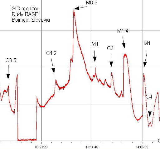
Waves of ionization are rippling through Earth's upper atmosphere in response to the recent onslaught of solar flares. This affects the propagation of radio signals--suppressing some frequencies and boosting others. By monitoring distant transmitters at a frequency of 23.4 kHz, of Bojnice, Slovakia detected nearly a dozen sudden ionospheric disturbances (SIDs) on Feb. 18th:

Ionization Chart
© Rudolf SlosiarHere is a chart from an observatory in Bojnice, one of the upcoming SID monitor the network. Individual peaks match exactly with the events as recorded by satellite SDO. It turns out that the greater the ionospheric D layer exposed to more radiation, the results of this method are more persuasive. Image taken: Feb. 18, 2011. Location: Bojnice, Slovakia
"Each surge in signal strength corresponds to a specific solar flare," notes Slosiar. "Individual peaks exactly match events recorded by Earth-orbiting satellites."

More waves of ionization are iin the offing as sunspot complex 1161-1162 continues to crackle with M-class solar flares. The next SID could be over your backyard. Do-it-yourself SID monitors are available from Stanford University.

Megaphone

Lava Lake at Kilauea has Reached One of its Highest Levels Ever

lava lake @ Kilauea
© Hawaii News Now
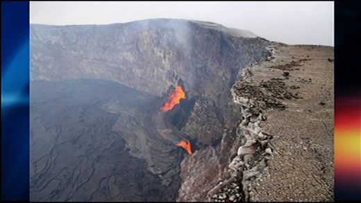
Scientists on the Big Island say it's been an especially active week at Kilauea volcano - as it continues to erupt in two locations: on the east rift zone and at the summit.

The volcanic activity along the summit has died down a little since Monday - when the lava lake at Halemaumau crater reached one of the highest levels ever observed. But it's still fascinating for both geologists and tourists alike.

Kilauea's fiery summit cauldron ripped open this week, and its beauty is matched only by the roar of its fury. Summit activity isn't as intense as it was earlier in the week, but the changes have delighted scientists.

"It is an exciting time for volcanologists," says Janet Babb of the U.S. Geological Survey's Hawaiian Volcano Observatory. "This is the job that we're trained to do and the kind of research that we're involved in, so it has been exciting."

On Monday, they watched as a number of rocks fell into Kilauea's summit vent. Sulfur dioxide emissions remain elevated. Babb explains, "Large sections of the rim of the vent fell into the lava lake below. It caused a lot of degassing, and in a few instances, some explosive events that caused a lot of dusty, ashy plumes to rise skyward."

Cloud Lightning

Goma Volcano Set for Another Eruption

eruption of Mt. Nyamuragira
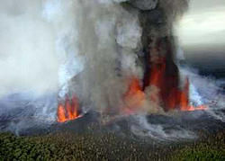
© planetdiary.comPrevious eruption of Mt. Nyamuragira
Previous eruptions in recent times may be dwarfed by the expected next eruption of Mt. Nyiragongo, which towers over the Eastern Congolese city of Goma. Nine years ago, in January 2002, when the region's most active volcano erupted, the reportedly rather liquid lava swiftly covered a sizeable part of the city and even brought air transport to a complete standstill, when a portion of the runway was covered by lava, which when finally cooled down, was measured to be 6 and more feet thick and as wide as a kilometer, leaving total destruction in its wake and making over 120,000 residents homeless.

The eruption then reached as far as Lake Kivu and only a major effort supported by the UN and international partners made the airport somehow usable again, albeit with a still shortened runway, which makes the use of larger aircraft impossible and impacts on the operations of the airport even with smaller jets. Accidents have, in fact, been recorded at Goma attributed at the shortened runway making every landing and take off an adventure of sorts.

An earlier major eruption in 1977 also caused similar havoc, but population numbers were considerably less back then and the main path of the lava was not directed frontally against Goma. There are reportedly only two main exit routes for the lava, as researchers have established and, therefore, the chance of Goma being hit again during the next eruption is 50/50.

Evil Rays

Ghana: Parts of Accra Metropolis experience tremor

Residents of some communities in Accra at dawn on Wednesday experienced what eyewitnesses described as an earth tremor.

The incident, which occurred around 0400 hours affected communities like Taifa, Dome, Tantra Hills, Achimota, Kwabenya, Ashongman and East Legon, from where residents called a local radio station for confirmation.

Official sources, however, could not confirm the incident to the Ghana News Agency (GNA) as the nation did not have the equipment to measure incidence of earthquakes or tremors.