Earth ChangesS


Bizarro Earth

UK: 3.9 Earthquake Strikes in Middle of Channel

Image
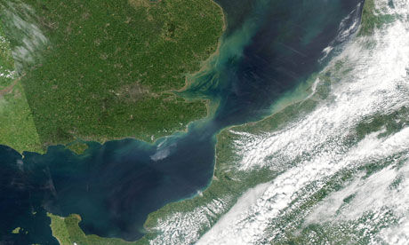
© Ho/AFP/Getty ImagesThe earthquake struck in the middle of the Channel and was felt by some residents in West Sussex.
West Sussex residents report buildings shaking for few seconds in 3.9 magnitude earthquake

An earthquake with a magnitude of 3.9 has struck in the middle of the Channel. Residents in parts of West Sussex reported buildings shaking for a few seconds at around 8am on Thursday.

The British Geological Survey said the quake had a depth of 10km and its epicentre was south of Portsmouth, Hampshire. Official measurements showed it happened at 7.59am BST.

Sussex police, the Solent coastguard and West Sussex fire and rescue service said they had not been called out to any incidents related to the quake.

David Kerridge, from the British Geological Survey, said the earthquake was the largest in the area since a magnitude 4.5 quake in 1734.
Bell

Best of the Web: Japan Earthquake And Tsunami Makes 2011 The Costliest Natural Disaster Year

Image
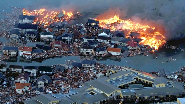
According to a German insurance company Munich Re, the devastating earthquake and tsunami that occurred in Japan earlier in the year has made 2011 the costliest year on record for natural disasters. Despite there being more than five months left in the year, the costs of rescue and recovery for the disasters that occurred on the southwestern coast of Japan has already eclipsed most natural disaster spending for many years past.

According to Japan's records, the total economic loss for the first six months of this year alone stands at $265 billion. This is 200 million more than what was spent in the entire year of 2005. 2005 had previously been the most expensive year, before the disasters that occurred this year. In 2005, hurricane Katrina had devastated most of the US southern states near and around New Orleans in America, setting the then record for costs in a natural disaster.

Arrow Down

Florida, US: Tarpon Springs homeowners wonder if homes will be swallowed by sinkhole

An engineering report on potential sinkhole activity in a Tarpon Springs neighborhood has homeowners wondering if their homes are going to be swallowed by the earth.

The Geotechnical Engineering Services Report commissioned by the city, following a sinkhole June 16, found "the subsurface soils ... are indicative of potential sinkhole activity." It means a city park and several surrounding homes are sitting atop ground that has voids in the subsurface that could collapse into a sinkhole.

"I've basically been living in fear," said Henry Collins who lives across the street from the park tested by the engineers. The engineers were called in after the earth collapsed beneath the home next door to Collins' house.

"Every night I can't sleep," said Collins. "Every noise, I get up and check because I don't know what it might be... It could be my house falling into the ground."

The city is expected to repair the subsurface of the park by pumping grout below the surface to fill the voids. However, homeowners are on their own. Collins says he cannot afford to hire a company to check the property beneath his home. "I'm just taking it one day at a time and hope for the best," said Collins.

Bizarro Earth

US: Largest landslide in New York history creeps down Adirondacks

Image
© Reuters/Andrew KozlowskiThe edge of a landslide in Keene Valley, New York is shown in this May 17, 2011 handout image.
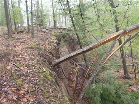
A mile-wide landslide that is unleashing hundreds of millions of tons of debris in New York's Adirondack Mountains is the largest in the state's history, but also one of its slowest.

Geologists say an 82-acre piece of earth on Little Porter Mountain in Keene Valley, New York, is creeping downhill at a rate of between just six inches and two feet per day, dragging boulders, trees and house foundations along with it.

Andrew Kozlowski, associate state geologist at the New York State Museum, said the uncommonly lazy slide was triggered by excessive groundwater from this year's heavy snows and rain.

The slide began May 6 and could last considerably longer, from a few months to many years, he said.

"That's the side of a mountain that's in full motion right now," Kozlowski said. "This thing isn't even close to being at equilibrium yet. There's every indication that this is going to continue to move for some time."

The landslide's mass is at least hundreds of millions of tons, he said. Measuring 0.8 of a mile wide, it is the largest landslide in New York history, he said.

Cloud Lightning

Alberta, Canada: Suspected Tornado hits southwest

Image
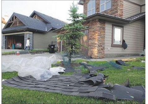
© Grant Black, Calgary HeraldA slab of shingles rests on the lawn of a home on Val Gardenia Place S.W. on Wednesday evening after a fierce summer storm damaged several homes on the Calgary cul-de-sac.
The fire department received numerous reports Wednesday evening of what looked like a tornado hitting homes on the western edge of the city.

Environment Canada could not confirm whether a tornado had actually touched down, but dark swirling clouds and high winds that ripped through roofs and eavestroughs on the 300 block of St. Moritz Drive S.W. forced residents to take shelter.

Fire spokesman Brian McAsey said calls started pouring in shortly before 8 p.m. about funnel cloud sightings and homes being damaged, including a call about part of a roof torn off a home.

Another house was believed to be hit by lightning, he said, adding there were also reports of flooding and manhole covers being blown off -but no reports of injuries.

Area resident Long Ren was home with his wife and daughter when he saw the trees moving around "crazily" in his backyard.

"Suddenly I saw a lot of stuff blowing into the sky and realized it could be a tornado," he said.

Bizarro Earth

New Zealand: 'Snow and ice everywhere' across south

Image
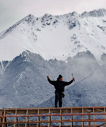
© BARRY HARCOURT/The Southland TimesON TOP OF THE WORLD: Te Anau builder Tony Rayfield thinks he still has the best job in the world regardless of the weather. With the Murchinson Mountains as a background, where in the world would you rather be.
Snow is falling intermittently in Invercargill while heavier dumps are beginning to affect roads and other services across the south.

However, most of the white stuff so far appears to be confined to the Fiordland region and the eastern coast of Southland and the Clutha district.

Warren Dickie, who farms on the Clinton-Matarua highway, said today's snow was not yet as bad as last year's big snow in September. ''Its just a bit cold and slippery, isn't it," he said.

Earlier this morning the snowfall had just been a light dusting on the ground but things changed quickly: "It's definitely ... a lot worse."

If the snow hung around as predicted for the next few days it could become more of a problem, he said.

Motorists appear to be heeding calls to be careful on southern roads, with no incidents reported to emergency services so far.

Te Anau police report a fresh cold snap this morning, with "snow and ice everywhere''.

Bizarro Earth

Indonesia: Over 2,000 evacuated in Mount Lokon eruption

Over 2,000 people have been displaced in the latest eruption from Indonesia's Mount Lokon, which is located on the northern tip of the island of Sulawesi, officials said Wednesday.

North Sulawesi Disaster Management Agency (BPBD) chief Hoyke Makarawung told Antara news agency that the total number of refugees, as of Wednesday at noon local time, was 2,116 people. The evacuees are all residents of Kinilow, Kinilow I and Kakaskasen villages, which are located in the sub district of North Tomohon, near the erupting volcano.

According to reports, one person died during the evacuation, which was carried out by BPBD, local authorities, the Indonesian Red Cross, military personnel, and local youth groups. However, Hoyke said the individual had previously suffered from strokes, and it is still uncertain whether the death was directly related to the eruption.

Cloud Lightning

US, Idaho: Severe Thunderstorms Move Through Upper Snake River Plain

A severe thunderstorm warning remains in effect until 315 pm mdt for north central Bonneville county, At 248 pm mdt, national weather service doppler radar continued to indicate a severe thunderstorm with hail up to 1 inch in diameter. This storm was located near Iona, or 8 miles northeast of Ammon, moving northeast at 20 mph. Locations that could be affected include, rural northern Bonneville county, Precautionary/preparedness actions, Stay tuned to this broadcast for the latest updates and information. To report severe weather only, call 1 800 8 7 7 1 9 3 7.

Severe Thunderstorm Warning: The NWS in Pocatello has issued a severe thunderstorm warning for: central Bingham county in southeast Idaho, this includes the city of Blackfoot, Until 330 pm mdt. At 242 pm mdt, national weather service doppler radar indicated a severe thunderstorm capable of producing quarter size hail, and damaging winds in excess of 60 mph. This storm was located near Gibson, or near Blackfoot, and moving northeast at 15 mph. Locations that could be affected include, Blackfoot, Rose, Precautionary/preparedness actions, This is a dangerous storm. If you are in its path, prepare immediately for damaging winds, destructive hail, and deadly cloud to ground lightning. People outside should move to a shelter, preferably inside a strong building but away from windows. Stay tuned to this broadcast for the latest updates and information. To report severe weather only, call 1 800 8 7 7 1 9 3 7.

Bizarro Earth

Iceland: Glacier flood confirmed from Vatnajökull glacier, flood is from Hamarinn volcano (Loki-Fögrufjöll area)

The harmonic tremor that started yesterday has been confirmed to be coming from Hamarinn volcano (Bárðarbunga volcano), but they are also known as Loki-Fögrufjöll in GVP database.

So far there is nothing that indicates an eruption is taking place at the moment in Hamarinn volcano. But that might change without warning. At the moment nobody is sure where the glacier flood is coming from. But this appears to be a new area of hydrothermal activity in Hamarinn volcano that is releasing water at the moment. This new hydrothermal area is most likely created by new dike intrusions into the bed rock in the affected area. There are no pictures of the affected area, as the area is impassible to air plains at the moment due to cloud cover or fog. Lack of earthquakes also makes it hard to locate the source of this glacier flood.

Currently the glacier flood has peaked and is getting lower. There not expected to be any damage from this glacier flood on human structures or roads. This area of Iceland is unpopulated. The water is going into large lakes in the area where the effects of this glacier flood are almost none. The glacier flood did flow into a dam lake that is collecting water from rivers that this glacier flood did go into. This did make the lake rise about 70 cm in several hours and fill it. No damage is expected from this glacier flood to the dam or other structures in this area connected to the dam. But it is estimated that 26 gigaliters did flow into the dam lake during the night from this glacier flood.

Bug

US: Stinky Kudzu Bug Invades South

Kudzu Bug
© D. Suiter / Univ. GeorgiaKudzu bugs, which feed on the infamous vine, showed up in Georgia in 2009.
As if kudzu, the invasive "vine that ate the South," weren't trouble enough, one of its little friends from Asia has joined it in the United States.

The kudzu bug, known formally as Megacopta cribraria, is a type of stinkbug that feeds the kudzu vine in its native Asia. While the invading vine is its favorite meal, the bug also attacks soybeans, and as it spreads from Georgia to neighboring states, there are fears it will broaden its palate and target other legume crops, including peanuts.

Kudzu was brought to the East Coast more than a century ago to control erosion. Its quick growth wreaked havoc on the ecosystem: It smothers and strangles other plants, uproots trees and breaks branches with its weight. The bug appears to have hitched a ride by accident much more recently. Just how remains a mystery.