Earth ChangesS


Cloud Lightning

US: Spring Flooding Underway, Expected to Worsen Through April

Image
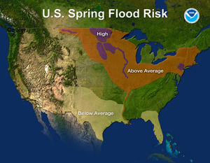
U.S. Spring Flood Risk Map for 2011.
With spring flooding already underway over portions of the U.S., NOAA forecasters are warning the worst is yet to come. Almost half the country - from the North Central U.S. through the Midwest and the Northeast - has an above-average risk of flooding over the next few weeks, according to the annual spring outlook released today by NOAA's National Weather Service. This week is also national Flood Safety Awareness Week, and NOAA has partnered with FEMA to encourage residents to prepare for this imminent threat.

The highest spring flood risk areas include the Red River of the North, which forms the state line between eastern North Dakota and northwest Minnesota, the Milk River in eastern Montana, the James and Big Sioux Rivers in South Dakota, the Minnesota River, the upper Mississippi River basin from Minneapolis southward to St. Louis, and a portion of lower New York, eastern Pennsylvania and northern New Jersey. Many metropolitan areas have a greater than 95 percent chance of major flooding, including Fargo, Grand Forks, St. Paul, Davenport, Rock Island, Sioux Falls and Huron. Devils Lake in North Dakota has an 80 percent chance of reaching two feet above last year's record of 1452.1 feet.

"For the third consecutive year, the stage is set for potential widespread, record flooding in the North Central United States," said Jack Hayes, Ph.D., director of NOAA's National Weather Service. "We've been coordinating with federal and state partners and high risk communities since December to raise awareness and help them prepare. All the ingredients are in place for major flooding so this situation should be taken very seriously. We're asking citizens to stay informed and be prepared."
Meteor

Kiawah Island, South Carolina, US: Booms revive an old mystery

The first boom sounded like thunder. The second shook windows. The third shook an entire house. Then they quieted, mysteriously.

The series of booms were reported Monday afternoon by people on Kiawah and Johns islands and Isle of Palms. At least three booms, each more intense than the last, occurred within 15 minutes starting about 3:30 p.m.

"There's another one. The third one, just now. It's like thunder getting closer to us, only there's no rumble, just a blast. Have you ever been around dynamite? A pretty good charge when they're blowing up stumps, that's what it's like," said Dwight Ives, who was on Kiawah Island during the booms.

"We felt the house shake," said Art Morgenstern, an island resident.

Attention

The Scariest Earthquake Is Yet to Come

The tsunami that struck Japan was the third in a series of events that now put California at risk.

All of those broken bones in northern Japan, all of those broken lives and those broken homes prompt us to remember what in calmer times we are invariably minded to forget: the most stern and chilling of mantras, which holds, quite simply, that mankind inhabits this earth subject to geological consent - which can be withdrawn at any time.

For hundreds, maybe for thousands of people, this consent was withdrawn with shocking suddenness - all geological events are sudden, and all are unexpected if not necessarily entirely unanticipated - at 2:46 on this past clear, cool spring Friday afternoon. One moment all were going about their quotidian business - in offices, on trains, in rice fields, in stores, in schools, in warehouses, in shrines - and then the ground began to shake. At first, the shock was merely a much stronger and longer version of the temblors to which most Japanese are well accustomed. There came a stunned silence, as there always does. But then, the difference: a few minutes later a low rumble from the east, and in a horrifying replay of the Indian Ocean tragedy of just some six years before, the imagery of which is still hauntingly in all the world's mind, the coastal waters off the northern Honshu vanished, sucked mysteriously out to sea.

Radar

USA: Tiny amounts of Japan's radiation reach California

Vienna - Japan's radioactive fallout has reached Southern California but first readings are "about a billion times beneath levels that would be health threatening," a diplomat with access to United Nations' radiation tracking said Friday.

The diplomat, who asked for anonymity Friday because the Comprehensive Test Ban Treaty Organization does not make its data public, cited readings Friday from one of the U.N.'s California-based measuring station.

IAEA officials and independent experts have emphasized that the radiation level was already low outside of the immediate vicinity of the crippled reactor.

They said it would dissipate so strongly by the time it reached the U.S. coastlines that it would pose no health risk whatsoever to residents there.

Any detectable radiation on Friday "could be coming from your own reactors in California," said physics Prof. Paddy Regan at the University of Surrey at Guildford in Britain.

A senior IAEA official who asked for anonymity because he was not authorized to speak to media, noted that even in Tokyo, "radiation was at background levels."


Bizarro Earth

Record Low Ozone in the Arctic

Ozone Layer
© Ross SalawitchArctic polar stratospheric clouds like these lead to ozone destruction.

The ozone hole over the south pole is a well-known phenomenon, opening up every spring, letting excess ultraviolet light stream in from the sun and driving up skin cancer risk down under.

But this year, ozone levels at the opposite pole are poised to reach record lows thanks to the right weather patterns and possibly a contribution from the changing climate.

"Don't panic," said Markus Rex of the Alfred Wegener Institute for Polar and Marine Research in Potsdam, Germany. "It's nothing which is a reason for great concern. Still people should have in mind that when they are outside in spring, sunburn times can drop to 20 minutes. People don't expect that in late March. You wouldn't expect to get a sunburn in the northern U.S. then."

While the ozone-depleted area is currently centered over the Arctic, the zone will shift as weather patterns change, and will pass over more populated areas as far south as about 45 degrees north -- roughly through Oregon, Minnesota and the New York-Canada border in North America -- and possibly even further.

"That system is moving around," Rex said. "Those air masses will sooner or later appear right over our own heads." The team predicts the low-levels will hover over eastern Russia by late March and will move on from there.

Rex and a global team of researchers monitoring satellite readings of ozone and temperature released the findings this week. In the past two weeks, ozone levels in the most ozone-rich part of the stratosphere have dropped by about 50 percent, Rex said, and about 30 percent overall, which is about as low as it has ever been.

Bizarro Earth

Australia: Stranded Whales Back at Sea

Stranded Whales
© Parks and WildlifeRescuers worked by moonlight to move the stranded whales beach back into the water.

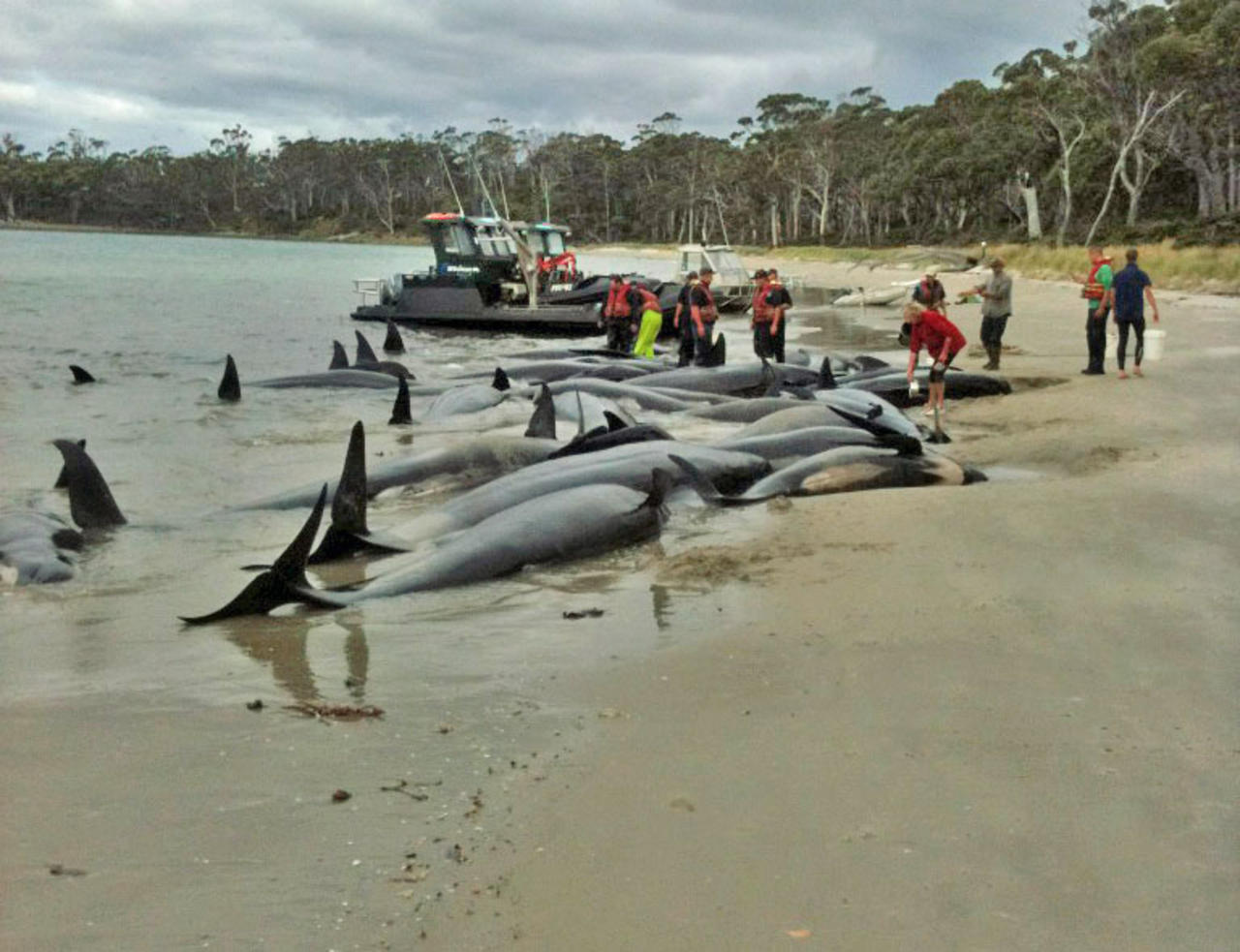
The surviving whales from a pod of 30 which stranded on Bruny Island in southern Tasmanian have been returned to the water.

Parks and wildlife rescuers worked under the light of a full moon to free 11 long-finned pilot whales on a beach on South Bruny Island.

The Parks and Wildlife Service's Rosemary Gales says the animals were returned to the water about 4:30am (AEDT) and have swum away.

"There's just been a sighting of some live whales that they're going to check out to determine if they're the same ones," she said.

Alarm Clock

40ft Section Of California Highway Falls Into Pacific Ocean

Image
Part of the highway that fell into the Pacific ocean on March 16th 2011
A stretch of California's coastal highway is closed to traffic indefinitely after a chunk of the road fell into the Pacific Ocean.

State transportation workers are scrambling to repair Highway 1 in Monterey County near Rocky Creek Bridge.

A 40-foot section of the two-lane highway crumbled just after 5 p.m. Wednesday following several days of rainy weather. All of the southbound lane is gone, and the soil under the northbound lane also is giving way.

The California Highway Patrol says no one was injured in the slide.

It's not immediately clear what caused the slide or how long the highway will be closed.


Comment: If people in the California area are not awake enough to take these VERY strong indicators that the West Coast of the USA is next in line for a major quake then what can ANYONE do to help them?


Telescope

Super Full Moon Coming Soon

Mark your calendar. On March 19th, a full Moon of rare size and beauty will rise in the east at sunset. It's a super "perigee moon"--the biggest in almost 20 years.

"The last full Moon so big and close to Earth occurred in March of 1993," says Geoff Chester of the US Naval Observatory in Washington DC. "I'd say it's worth a look."

Full Moons vary in size because of the oval shape of the Moon's orbit. It is an ellipse with one side (perigee) about 50,000 km closer to Earth than the other (apogee): diagram. Nearby perigee moons are about 14% bigger and 30% brighter than lesser moons that occur on the apogee side of the Moon's orbit.


"The full Moon of March 19th occurs less than one hour away from perigee--a near-perfect coincidence1 that happens only 18 years or so," adds Chester.

A perigee full Moon brings with it extra-high "perigean tides," but this is nothing to worry about, according to NOAA. In most places, lunar gravity at perigee pulls tide waters only a few centimeters (an inch or so) higher than usual. Local geography can amplify the effect to about 15 centimeters (six inches)--not exactly a great flood.

Question

Australia: Mystery stink bogs down authorities

Image
© UnknownRobert Burnett shows the source of the smells near Edgars Creek in Coburg North
Authorities have been unable to determine the cause of a mysterious smelly bog near Edgars Creek.

Friends of Edgars Creek environment group have raised the alarm over a "sewage" stench emitting from the permanently wet grassy slope on Moreland Council land near the former Kodak site.

Former president Stephen Northey said what was a small boggy patch two years ago had expanded into a 150m bog.

To date, its appearance and growth has baffled environmental and water authorities.

Moreland Council said tests by its officers, the EPA, Yarra Valley Water and Melbourne Water had failed to determine the cause.

Question

Another case of outgassing? UK: Mystery surrounds Llanelli chemical alert

Image
© UnknownPeople were allowed to return to their homes at about 2200 GMT on Wednesday
Mystery surrounds the cause of strong gas smells which caused a mass evacuation of houses and a care home in Llanelli.

Hundreds were allowed to return home at about 2200 GMT on Wednesday after people had been moved to safety because of a suspected chemical leak.

Tests by environmental health and Welsh Water did not detect chemicals.

A precautionary cordon had been set up around homes within a square mile of Thomas Street.

Firefighters were called to Felinfoel Road in Llanelli at 1755 GMT by Dyfed-Powys Police.