Earth Changes
"Insane depth of cold" to blast Britain.
An "insane depth of cold" is set to strike the UK over the Easter weekend, warns the Weather Outlook's Brian Gaze.
Freezing temperatures and frosts will arrive in Scotland on Thursday, April 1, with "polar spring" conditions engulfing the majority of the country by Good Friday.
Looking further ahead, the mercury is expected to sink even lower during the following week, as a violent kink in the jet stream (associated with the historically low solar activity we continue to experience) delivers Arctic air to the lower-latitudes.
Thermometers could sink to -10C (14F) in northern parts, which would topple all-time daily cold records.
The UK's lowest-ever recorded temperature for April 5, for example, is the -9C (15.8F) set in 1990, while 1935's -8.9C (16F) for April 7 could also tumble. In fact, most of the daily benchmarks between early-to-mid April are under threat, including some that have stood for more than a century.
"During different times this season it has been the number one snow pack in the county - currently it's over 600 inches (50 feet)at the top of Alpental," said Guy Lawrence, general manager at Summit at Snoqualmie. Fifty feet! That's the height of a 5-story building!
And that will continue growing, because more spring snow is expected.
"Next week we're probably going to get a couple of systems that will bring snow to the higher elevations in the Cascades," said Nick Bond, a professor at the University of Washington and a state climatologist.
The epicenter, with a depth of 597.77 km, was initially determined to be at 21.8731 degrees south latitude and 179.3414 degrees west longitude.
Comment: In the same region of the Pacific Ocean and a little over 5 hours earlier a huge 6.6 magnitude earthquake struck just off the Kermadec Islands.
Thundersnow is simply a thunderstorm that occurs when it is just warm enough for a storm but still cold enough for the storm to produce snow instead instead of rain.
Alex Inscoe captured the weather event on video. It shows lightning during a snowstorm which brought half inch of snow to the airport between 10:15 p.m. and 10:45 p.m.
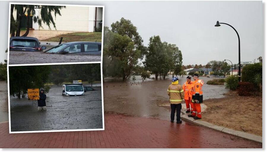
Rainfall that resulted in last month's flood crisis across the Australian state of New South Wales (NSW) was more than double the average, making it the second-wettest March on record, the Bureau of Meteorology (BoM) said on Thursday.
Extensive areas of flooding resulted from the torrential rain, killing one person and forcing thousands to evacuate their homes, dpa news agency reported.
The disaster is estimated to have caused A$2 billion ($1.5 billion) in damage, according to the Australian Financial Review.
The tremor is the latest in a a series of 34 in the region in the last day, the USGS has said. It struck at a depth of 6.2 miles. There is currently no tsunami alert in force - but a series of quakes did trigger one earlier this month.
Seismic activity is commonplace in the region, located within the so-called Ring of Fire which stretches around the Pacific Basin.
On Monday, the American Geophysical Union tweeted: "An M8.1 #earthquake off the coast of #NewZealand triggered an estimated 300 #landslides on #RaoulIsland, the largest of the #Kermadec Islands.
Based on the Taal Volcano Network (TVN), 212 quakes, including 168 tremors with durations one to 20 minutes, and 44 low frequency volcanic earthquakes were recorded.
Some 1, 229 tons of sulfur dioxide were emitted by the volcano in Batangas province in the past 24 hours, according to Phivolcs chief Renato Solidum.
Solidum said with the volcano under Alert Level 2, an increased unrest may lead to an eruption and advised "all concerned to remain vigilant".
"The fact that we have volcanic tremors and prolonged background tremor recorded, higher than normal sulfur dioxide emission rate of 923 tons per day, slow but steady inflation of the volcano still indicates magmatic activity at shallow depth beneath the volcano," he said.
Comment: View also: Spring snowfall suprises residents of Magadan in Russia's east