Earth ChangesS


Arrow Up

Rare River Porpoises Showing up Dead

Dead Porpoise
© Xu Dianbo/China DailyVolunteers from Yueyang, Hunan province, carry the corpse of a finless porpoise from Dongting Lake on Saturday.
Within the last month and a half, the corpses of 12 endangered finless porpoises, including a pregnant one, have been found around Dongting Lake, Hunan province.

It has triggered worries from experts about the rare species possibly becoming extinct.

Scientists said finless porpoises, which have lived in the Yangtze River and adjacent lakes for more than 20 million years, will become extinct within 15 years. The porpoises are also called "river pigs".

"Apparently the prolonged drought and low water level due to climate change and increasing offshore human activities are reducing the living space for finless porpoises, accelerating its extinction," Wang Kexiong, an expert of the Institute of Hydrobiology under the Chinese Academy of Sciences, told China Daily.

It is the first time he has heard of so many dead porpoises found within such a short period.

Xu Yaping, a journalist from Hunan's Yueyang city who is campaigning to ensure the survival of the species, said when most of the corpses were dissected no food was found in their digestion systems.

Xie Yongjun, an associate professor of animal husbandry at Yueyang Vocational and Technical College, told China Daily the porpoises may have died due to starvation, poisoning or infectious disease.

There were no obvious injuries in the three corpses he dissected, Xie added.
Bizarro Earth

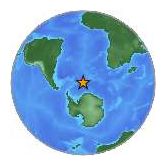
USGS: Earthquake Magnitude 6.2 - East of The South Sandwich Islands

Sandwich Islds Quake_170412
© USGSEarthquake Location
Date-Time:

Tuesday, April 17, 2012 at 19:03:55 UTC

Tuesday, April 17, 2012 at 06:03:55 PM at epicenterTime of Earthquake in other Time Zones

Location:

59.099°S, 16.693°W

Depth:
1 km (~0.6 mile) (poorly constrained)

Region:
EAST OF THE SOUTH SANDWICH ISLANDS

Distances:

563 km (349 miles) E of Bristol Island, South Sandwich Islands

677 km (420 miles) ESE of Visokoi Island, South Sandwich Islands

2685 km (1668 miles) SE of STANLEY, Falkland Islands

4091 km (2542 miles) SE of BUENOS AIRES, D.F., Argentina

Bizarro Earth

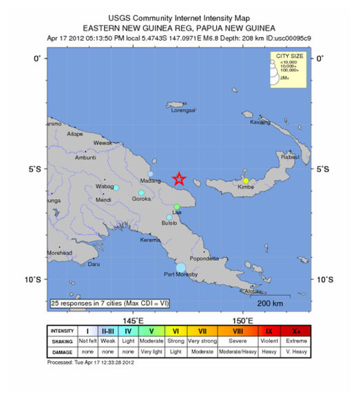
USGS: Earthquake Magnitude 6.8 - Papua New Guinea

PNG Quake_170412
© USGSEarthquake Location
Date-Time:
Tuesday, April 17, 2012 at 07:13:50 UTC

Tuesday, April 17, 2012 at 05:13:50 PM at epicenterTime of Earthquake in other Time Zones

Location:
5.474°S, 147.097°E

Depth:
208.2 km (129.4 miles)

Region:
EASTERN NEW GUINEA REG, PAPUA NEW GUINEA

Distances:

139 km (86 miles) N of Lae, New Guinea, PNG

146 km (90 miles) ESE of Madang, New Guinea, PNG

440 km (273 miles) N of PORT MORESBY, Papua New Guinea

2516 km (1563 miles) NNW of BRISBANE, Queensland, Australia

Better Earth

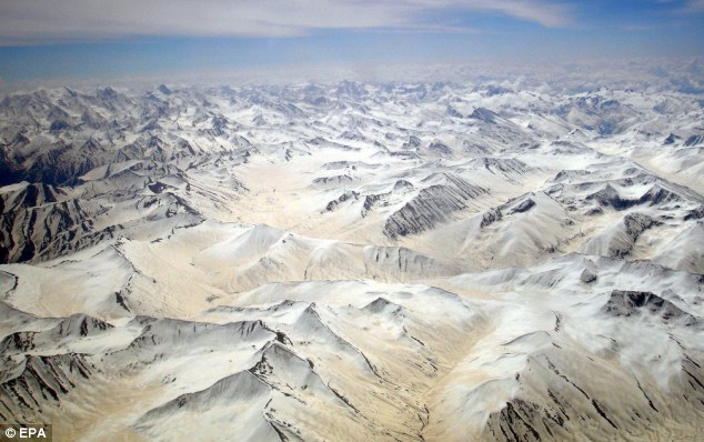
Forget global warming: Scientists discover glaciers in Asian mountain range are actually getting BIGGER

Photos taken by a French satellite show glaciers in a mountain range west of the Himalayas have grown during the last decade.

The growing glaciers were found in the Karakoram range, which spans the borders between Pakistan, India and China and is home to the world's second highest peak, K2.

The startling find has baffled scientists and comes at a time when glaciers in other parts of the region, and across the world, are shrinking.

Image
French scientists from the National Centre for Scientific Research and the University of Grenoble, were forced to rely on satellite images, to study the region - because much of the Karakoram range is inaccessible.

They compared observations made in 1999 and 2008 and found a marginal mass increase.

They estimated the glaciers had gained between 0.11 and 0.22 metres of ice each year.

Bizarro Earth

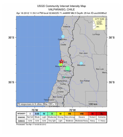
USGS: Earthquake Magnitude 6.7 - Valparaiso, Chile

Chile Quake_160412
© USGSEarthquake Location
Date-Time:
Tuesday, April 17, 2012 at 03:50:16 UTC

Monday, April 16, 2012 at 11:50:16 PM at epicenter

Time of Earthquake in other Time Zones

Location:
32.692°S, 71.449°W

Depth:
37 km (23.0 miles)

Region:
OFFSHORE VALPARAISO, CHILE

Distances:
42 km (26 miles) NNE of Valparaiso, Valparaiso, Chile

81 km (50 miles) W of Los Andes, Valparaiso, Chile

101 km (62 miles) N of San Antonio, Valparaiso, Chile

112 km (69 miles) NW of SANTIAGO, Region Metropolitana, Chile

Bizarro Earth

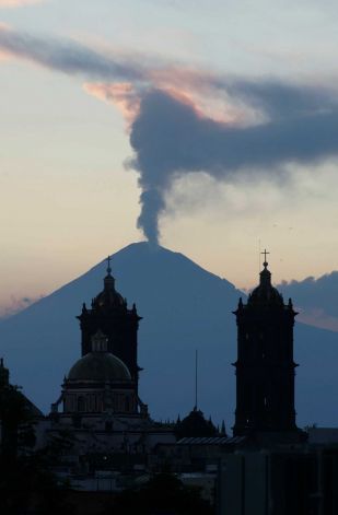
Mexico's Popocatépetl Sleeping Volcano Awakens

steam rises from the Popocatepetl volcano
© Joel Merino / APA plume of steam rises from the Popocatepetl volcano seen from the city of Puebla, Mexico, Saturday April 14, 2012.
Popocatépetl, the nearly 18,000 foot volcano that hovers like a sentinel on the southeastern fringe of Mexico's capital, awakened again Sunday, punctuating an especially shaky seismic season.

Popo, as the mountain is widely called, spewed at least seven exhalations overnight Saturday and through the day Sunday, sending vapor, smoke and gas billowing into the clear sky. The most serious occurred just after 9 a.m. Sunday, sending a vapor cloud a mile into the air.

Mexico's National Disaster Prevention Center issued a precautionary warning to residents, advising them to stay alert for a worsening situation and to keep at least seven miles away from the volcano's crater.

The service predicted continuing "moderate exhalations, some with ash, sporadic low to moderate explosions with likely burning fragments emitted close to the crater, and flaming magma within the crater visible at night."

Popo's latest fuming comes amid a series of earthquakes striking southern and central Mexico in the past three weeks. Several 6 magnitude quakes struck Wednesday, but no damage. A midday 7.4 quake on March 20 damaged hundreds of buildings in Oaxaca and Guerrero states and sent hundreds of thousands of residents scrambling into Mexico City's streets.

Cloud Lightning

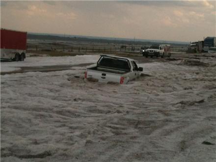
Bizarre hailstorm dumps four feet of hail in Texas Panhandle

Image
© Doug Black/KVIIAn unusual spring storm in the Texas Panhandle Wednesday afternoon dumped two to four feet of hail near Dumas.
Video | News | Weather | Sports

Thu Apr 12 06:10:35 PDT 2012

Photos: Spring hailstorm pelts Texas Panhandle

An unusual spring storm in the Texas Panhandle Wednesday afternoon dumped two to four feet of hail near Dumas. view full article


An unusual spring storm in the Texas Panhandle Wednesday afternoon dumped two to four feet of hail near Dumas.

Trucks were reported sliding off the road on Highway 287 as a result of the unexpected weather phenomenon. Snow plows were being used to clear the roads.

Some vehicles were trapped in the drifts of hailstones.

Chief Meteorologist Pete Delkus said a tornado watch was in effect for the Panhandle region through 10 p.m. Wednesday, and the storms were moving very slowly between Pampa and Dumas north of Amarillo and to the east of Dalhart.

Melting hail and heavy rain triggered flash flooding in the Panhandle.

Bizarro Earth

USGS: Earthquake Magnitude 5.5 - Southern Greece

Image
© USGS
Date-Time:
Monday, April 16, 2012 at 11:23:44 UTC
Monday, April 16, 2012 at 02:23:44 PM at epicenter

Time of Earthquake in other Time Zones

Location:
36.771°N, 21.692°E

Depth:
36 km (22.4 miles)

Region:
SOUTHERN GREECE

Distances:
55 km (34 miles) SW of Kalamata, Greece

135 km (83 miles) SSE of Zakynthos, Greece

169 km (105 miles) S of Patrai, Greece

232 km (144 miles) SW of ATHENS, Greece

Blackbox

Underground water in eastern Shasta County California mysteriously disappears

Image
© Andreas FuhrmannStephen Wolf of Cassel is a former United States Geological Survey worker who has a theory about why wells are running dry in eastern Shasta County.
Stephen Wolf thinks something strange is happening underground in eastern Shasta County and it is draining water wells and maybe even causing sinkholes and subsiding pavement.

A retired marine geologist with the U.S. Geological Survey, Wolf said he has seen what is happening in eastern Shasta County before. After the 1989 Loma Prieta earthquake, water well levels in the area of the quake fell significantly, he said.

Following the 6.9 magnitude quake in the Santa Cruz Mountains, Wolf wrote a paper for the USGS about the effects the quake had on surface and groundwater.

"The correlation is there. The behavior is identical," said Wolf, who has lived in the tiny eastern Shasta County community of Cassel since 2001.

Back in October, 131 earthquakes hit the Lassen Peak area. Most were less than 2.0 in magnitude. But since then the water table has fallen significantly, Wolf said.

Snowflake

Top Scientists, Government Agencies and Publications Have - For Over 100 Years - Been Terrified of a New Ice Age

ice age London
© Twentieth Century Fox
Fear of the Big Freeze

There has been an intense debate among leading scientists, government agencies and publications over whether the bigger threat is global warming or a new ice age. As we've previously noted, top researchers have feared an ice age - off and on - for more than 100 years. (This post does not weigh in one way or the other. It merely presents a historical record.)

On February 24, 1895, the New York Times published an article entitled "PROSPECTS OF ANOTHER GLACIAL PERIOD; Geologists Think the World May Be Frozen Up Again", which starts with the following paragraph:
The question is again being discussed whether recent and long-continued observations do not point to the advent of a second glacial period, when the countries now basking in the fostering warmth of a tropical sun will ultimately give way to the perennial frost and snow of the polar regions.
In September 1958, Harper's wrote an article called "The Coming Ice Age".

On January 11, 1970, the Washington Post wrote an article entitled "Colder Winters Held Dawn of New Ice Age - Scientists See Ice Age In the Future" which stated:
Get a good grip on your long johns, cold weather haters - the worst may be yet to come. That's the long-long-range weather forecast being given out by "climatologists." the people who study very long-term world weather trends.