Earth ChangesS


Bizarro Earth

US: Millions of Dead Fish in California: Volunteers Needed to Help Clean up Redondo Beach Dead Fish

Image
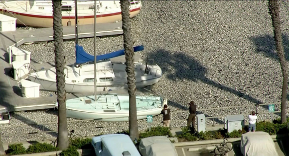
© KTLA-TVMillions of dead fish coat the water's surface in King Harbor in Redondo Beach, March 8, 2011.
Officials say the fish died from oxygen deprivation in the marina.

Heal the Bay, one of Southern California's leading ocean advocates, is looking for volunteers to help clean up millions of dead fish that washed up in King Harbor near Redondo Beach on Tuesday.

City public works crews cleaned up 35 tons of fish with skimmers and bulldozers on Tuesday, but much more work remains to be done.

The dead fish, mostly sardines along with anchovies and mackerel, floated up to the surface from the ocean floor.

About 200 city workers and 75 volunteers are working to get the fish out of the harbor. Redondo Beach officials estimate that the clean-up will cost at least $100,000.

Volunteers are working daily from 9 a.m. to 6 p.m.. "No experience or supplies are required -- only enthusiasm," Heal the Bay said in a statement on their website Wednesday.

Heal the Bay also said they are analyzing ocean conditions along with the Redondo Beach SEA Laboratory and the University of Southern California.
Sun

Powerful X-Class Solar Flare

March 9th ended with a powerful solar flare. Earth-orbiting satellites detected an X1.5-class explosion from behemoth sunspot 1166 around 2323 UT. A movie from NASA's Solar Dynamics Observatory shows a bright flash of UV radiation plus some material being hurled away from the blast site:


After four years without any X-flares, the sun has produced two of the powerful blasts in less than one month: Feb. 15th and March 9th. This continues the recent trend of increasing solar activity, and shows that Solar Cycle 24 is heating up. NOAA forecasters estimate a 5% chance of more X-flares during the next 24 hours.

Cloud Lightning

US: Northeast next after twisters, floods hit South

Alabama, Louisiana declare emergencies; N.J. expects 'significant event'

Alabama and Louisiana on Wednesday declared states of emergency after twisters hit some areas, while floods submerged others - all part of a severe storm system making its way to the Northeast, where significant flooding was expected Thursday.

In New Jersey, Gov. Chris Christie late Wednesday declared a state of emergency for areas along the Passaic and Delaware rivers and flood-prone Bound Brook in Somerset County.

In the South earlier Wednesday, winds tore roofs off buildings, overturned cars and injured several people. A woman died in a house fire in Mississippi that authorities believe was caused by lightning.

Two apparent tornadoes damaged buildings near Mobile in southwest Alabama, hours after several tornadoes were reported to the west near New Orleans, La.

Several tornadoes also touched down in southern Mississippi damaging some mobile homes, according to the police department in Biloxi.


Bizarro Earth

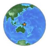
Papua New Guinea: Earthquake Magnitude 6.5 - New Britain Region

PNG Quake_090311
© USGSEarthquake Location
Date-Time:
Wednesday, March 09, 2011 at 21:24:51 UTC

Thursday, March 10, 2011 at 07:24:51 AM at epicenter

Time of Earthquake in other Time Zones

Location:
6.022°S, 149.659°E

Depth:
29 km (18.0 miles)

Region:
NEW BRITAIN REGION, PAPUA NEW GUINEA

Distances:
27 km (17 miles) NNE (31°) from Kandrian, New Britain, PNG

305 km (189 miles) ENE (75°) from Lae, New Guinea, PNG

341 km (212 miles) NNE (27°) from Popondetta, New Guinea, PNG

469 km (292 miles) NE (35°) from PORT MORESBY, Papua New Guinea

Bizarro Earth

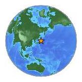
Japan: Earthquake Magnitude 6.1 - Near The East Coast of Honshu

Honshu Quake4_090311
© USGSEarthquake Location
Date-Time:
Wednesday, March 09, 2011 at 21:22:18 UTC

Thursday, March 10, 2011 at 06:22:18 AM at epicenter

Time of Earthquake in other Time Zones

Location:
38.385°N, 142.642°E

Depth:
23 km (14.3 miles)

Region:
NEAR THE EAST COAST OF HONSHU, JAPAN

Distances:
154 km (95 miles) E of Sendai, Honshu, Japan

194 km (120 miles) SE of Morioka, Honshu, Japan

201 km (124 miles) E of Yamagata, Honshu, Japan

395 km (245 miles) NE of TOKYO, Japan

Question

Labrador, Canada: Dead seals mystery not solved by scientists' tests

Image
© Derrick LettoA young seal on a beach near the southern Labrador community of L'Anse au Clair in early January.
Scientists say they've been unable to solve the mystery of dead seals that washed ashore in Labrador between December and January.

More than 200 harp seals turned up dead across remote beaches along the coast of the province.

"It's really one that's got us baffled," said Dr. Garry Stenson, a biologist with Fisheries and Oceans Canada.

When Stenson received reports of seals turning up dead, he flew into towns in northern Newfoundland and Labrador to collect their frozen carcasses.

Bizarro Earth

Japan: Earthquake Magnitude 6.0 - Off The East Coast of Honshu

Honshu Quake3_090311
© USGSEarthquake Location
Date-Time:
Wednesday, March 09, 2011 at 18:44:35 UTC

Thursday, March 10, 2011 at 04:44:35 AM at epicenter

Time of Earthquake in other Time Zones

Location:
38.492°N, 143.191°E

Depth:
1.2 km (~0.7 mile)

Region:
OFF THE EAST COAST OF HONSHU, JAPAN

Distances:
203 km (126 miles) E of Sendai, Honshu, Japan

221 km (137 miles) SE of Morioka, Honshu, Japan

250 km (155 miles) E of Yamagata, Honshu, Japan

436 km (270 miles) NE of TOKYO, Japan

Bizarro Earth

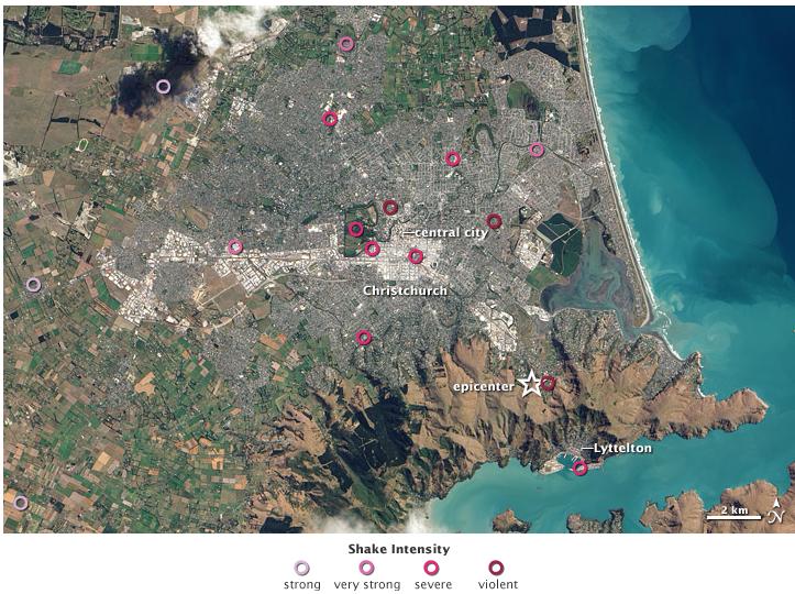
Shaking Intensity, Christchurch Earthquake

Christchurch Earthquake
© Earth Observatory / NASANASA Earth Observatory image by Robert Simmon, using ALI data from the EO-1 Team and USGS Earthquake Hazard Program. Acquired March 4, 2011.

It is a modern human tendency to focus on the number of an earthquake - specifically, the magnitude, or what people used to call the "Richter scale." But the destruction from a quake usually has more to do with location and timing. Such was the case with the earthquake in Christchurch, New Zealand, on February 22, 2011.

A September 2010 earthquake centered 40 kilometers (25 miles) west of Christchurch, in the plains near Darfield, struck at 4:35 a.m., had a magnitude of 7.1, and caused some structural damage and one death (by heart attack). The earthquake in February 2011 occurred at 12:51 p.m. and just 10 kilometers (6 miles) from the center of Christchurch. It had a magnitude of 6.3, though was officially classified - scientifically speaking - as an aftershock of the 2010 quake. At least 166 people died, and the city of Christchurch was devastated structurally and emotionally. Many people are still missing.

The natural-color image above was captured on March 4, 2011, by the Advanced Land Imager (ALI) on NASA's Earth Observing-1 (EO-1) satellite. Overlain on the map are seismological measurements of the ground shaking in the Christchurch area on February 22, as noted by the U.S. Geological Survey's Earthquake Hazard Program.

Bizarro Earth

Israel: Torrential rains hit and snow falls on the Hermon

Image
© Marc Israel SellemRain in Jerusalem.
Heavy precipitation, thunderstorms, cause traffic jams in Tel Aviv area, northern Israel; snow expected to spread to upper Galilee, Safed.

A recent blast of cold air from Scandanavia coupled with warm Mediterranean Sea influence created torrential rain and thunderstroms Tuesday. Snow fell in the Hermon and other areas in the north.

The morning hours saw between 10-30 mm of rainfall in the country's center, and between 5-15 mm in the North, with the Israeli Meteorological Service reporting up to 32 mm in the Tel Aviv area. Showers are expected to dissipate in the afternoon hours. Authorities closed the Hermon to visitors as snow began to fall.

The northern heights of Meron and Safed may see snow Wednesday or Thursday, but snow is not expected to hit the ground in Jerusalem.

The stormy weather wreaked havoc on motorways as well, causing heavy traffic in the Center and even worse traffic jams in the North. In the Kirya junction in Tel Aviv, a traffic disturbance developed when traffic lights malfunctioned and jammed the roads until a police officer arrived to help direct traffic.

Bizarro Earth

Hawaii: Level of volcanic gas elevated with new eruption

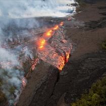
Image
© USGS
Kilauea Volcano - A new eruption near Pu'u 'o'o Crater on the Big Island that began March 5 has led to a dramatic increase in sulfur dioxide gas, one of two main ingredients in vog.

In recent months the east rift zone of Kilauea Volcano had been releasing 300 to 400 tons of sulfur dioxide gas every day.

After the new eruption of the mile-and-a-half long fissure this past Saturday, the amount of SO2 gas has increased to 10,000 tons per day.

"It's hard to say how long that might go on," said United States Geological Survey spokesperson Janet Babb, whose part of a team that helps monitor Kilauea. "The elevated SO2 emission that we're seeing corresponds to that high lava effusion rate."

Currently the new eruption is spewing 2.5 million cubic meters of lava per day in an unpopulated area, five times the recent average of a half million cubic meters per day.

For now the increase in lava and volcanic gas is not having a major impact on residents.