Earth ChangesS

Mail

US: Alabama tornadoes - FEMA letters ruffle Bentley

Image
© UnknownGov. Robert Bentley.
Gov. Robert Bentley has asked the Federal Emergency Management Agency to revise letters being sent to storm victims who have been found ineligible for FEMA grants because he believes the letters are insensitive.

Out of the 72,000 people who have applied, 20,600 have received notice that they aren't eligible for a grant -- almost twice as many as have received FEMA grants so far.

FEMA has encouraged anyone who suffered damage from the tornadoes that touched down April 27 to apply to the agency. According to the agency, many of the applicants found ineligible could still receive aid. Some were initially rejected because of incomplete information or due to pending insurance claims. FEMA cannot, by law, duplicate benefits paid by insurance companies, but in some circumstances can help with damage or expenses beyond insurance coverage.

The FEMA application process also puts the applicant in the pipeline for other federal aid, such as low-interest loans from the Small Business Administration, which are available to homeowners and businesses.

Cloud Lightning

India: Thunderstorm, rain kills 37

Image
© Unknown
At least 37 people were killed and 27 others injured in UP as thunderstorm, accompanied by lightning and rains, hit most of north India. Winds of 75-90 km/hr lashed through the states of UP, Bihar, West Bengal, Himachal Pradesh, Delhi, Uttarakhand, Jammu & Kashmir, Rajasthan, Punjab and Haryana
related stories

In Shahjahanpur district, 16 people were killed in dust storm related incidents while nine people lost their lives and 18 others were injured in Badaun, a district administration official said here on Saturday. In an unconfirmed report, two persons died in Bareilly district because of the storm.

Eight persons died in Lakhimpur Kheri, including a three-year-old girl, when a house collapsed and trees got uprooted. Three persons have been reported dead in Ghaziabad and one in Azamgarh.

Principal secretary (revenue) KK Sinha said orders had been issued to provide speedy help and compensate the families of the victims.

Windstorm in north Kashmir's Kupwara district damaged 32 houses in the past two days, officials said.

The Met department attributed the thunderstorm and rains to upper cyclonic circulations over north India and Pakistan and southwesterly winds. More thunderstorms and rains have been forecast over the next 48 hours.

Power supply was badly hit in parts of UP, trains and vehicular traffic was disrupted in Bihar and in Himachal Pradesh, apple and stone fruit crops were damaged in many parts. Heavy rains lashed West Bengal, too.

Cloud Lightning

US: Mississippi River's flood is dangerous to navigate

Image
© AP Photo/U.S. Coast GuardCoast Guard Commandant Adm. Bob Papp, left, is briefed Friday by Eighth Coast Guard District Commander Rear Adm. Mary Landry as he tours the Coast Guard Cutter Greenbrier and the Cutter Support Team at the Natchez Moorings in Natchez, Miss. Area crews are responding to the Mississippi River floods and preparing to deal with the aftermath.
Baton Rouge, La. - Travis Morace has been running boats on the Mississippi for two decades, witnessing the mighty river's many moods. He's seen it calm and smooth as a paved road and endured rides filled with treacherous twists and bumps.

But even experienced river pilots have never seen anything like the roiling current now racing to the Gulf of Mexico. Since spring floods pushed the Mississippi to historic heights, America's busiest inland waterway has become one of its most challenging to navigate.

"If you're not scared of it, you should be, because it has a lot of ways of hurting you," Morace said this week as he slowly nudged his tugboat, the Bettye M. Jenkins, along the river bank near Vidalia, La.

Now frightening

The high water brings with it a host of hazards. Debris is everywhere, and the unusually swift current makes it difficult for pilots to go upstream. Good luck stopping if you're headed downstream. For those who make their living on the water, the river is a respected adversary in the best of times. Now it just plain frightens them.

Better Earth

US: How the Floods May Restore Louisiana's Wetlands

Image
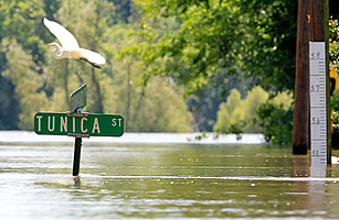
© Sean Gardner/ReutersA crane flies over a street sign near a rule measuring the height of the floodwaters in feet, in St. Francisville, Louisiana May 17, 2011. Scores of U.S. heartland rivers from the Dakotas to Ohio have flooded following a snowy winter and heavy spring rains, feeding near-record crests on the lower Mississippi River.
The talk of New Orleans has centered on whether the most severe Mississippi River flood in more than a quarter-century will cause catastrophic damage to a city still recovering from Hurricane Katrina. And for good reason: the flood has carved a destructive path from from Cairo, Illinois, to Vicksburg, Mississippi, and prompted Louisiana's Republican governor, Bobby Jindal, to ask the federal government for emergency assistance. But there just might be a silver lining: the flood could actually help Louisiana's fragile wetlands.

To be sure, the Mississippi River's floodwaters are destructive. Many people along the spillways opened to alleviate the surge are likely to lose their homes. The water may also destroy oyster beds, especially in Lake Borgne, between the Mississippi River and the Gulf of Mexico. Longer-term effects won't be clear for several months. But, says Alex Kolker, a geologist at the Louisiana Universities Marine Consortium, it may be an opportunity to let nature help resolve a man-made problem. "It's going to be a fascinating time," says Kolker.

Only a year ago, the worst oil spill in American history slathered millions of gallons of oil across Louisiana's coast. The muck covered the tall, bamboo-like cane and short grass that stitches together the vegetation that makes up the wetlands south of New Orleans, preventing them from receiving oxygen. Many experts feared it would take years for the wetlands to recover, and that Louisiana's core seafood industry - especially the oysters, which unlike shrimp and fish cannot run away from hint of oil - was imperiled. Such sediment is crucial: the loss of vegetation quickens erosion of soil and islands.

Bizarro Earth

US: Yellowstone National Park is Moving

Yellowstone Park
© ABC4.comGeyser in Yellowstone National Park.

Yelllowstone National Park, Wyoming - The nation's oldest park is also one of the most studied. The interest is not just in it's amazing vistas and wildlife, but in the volcanic beast below the park.

Yellowstone sits atop one of the world's biggest, active volcanoes, one capable of laying waste to much of north America.

Scientists keep an eye on it using a network of seismic and GPS sensors.

Professor Emeritus Robert Smith of the University of Utah is one of those scientists. A geophysicist, Smith a leading expert on the Yellowstone super volcano. "We monitor it in real time for earthquake swarms and ground deformation."

He says the park is in constant motion. Visitors can't see it, but the ground at their feet is moving up and down as magma pushes against the thin crust and powers the park's many geysers.

Evil Rays

Do Earthquakes Give off Warning Signals?

seismograph
© n/a
A team of NASA and Russian scientists thinks it's found a way to predict earthquakes. If it works, it could save a lot of lives. However, not all earthquake scientists agree with these findings.

The March 11 earthquake in Japan was a magnitude 9.1. A team of scientists monitoring quakes there say they could tell it was coming because the atmosphere above the epicenter was heating up from eight days before.

Russian scientist Dimitar Ouzounov says stresses on the Earth's crust leading up to a quake cause gases like radon to escape into the atmosphere -- 100 miles above the Earth they ionize and create heat that is detectable by satellites. Ouzounov's team says out of 24 quakes in Japan of magnitude 7 or greater, all showed the same atmospheric signals beforehand.

Better Earth

SOTT Focus: From Where I Sit: Raindrops Keep Fallin' On My Head

BS Meter
© naThe BS meter is pegged.
A friend just sent me a link to an article: Iran accused of September 11 role

All I can say is: that is just PATHETIC!

Anyway, the only reason I'm writing this late is because something is bugging me.

What struck me tonight were a number of strange juxtapositions. First off, there are the items about weather and earthquake weapons that made the rounds over the past week or so. The first one was about former Defense Secretary Cohen openly referring to HAARP when he admitted to programs that could "alter the climate, set off earthquakes, volcanoes remotely through the use of electromagnetic waves." Search for it on the net, you'll find it on a bunch of conspiracy sites (not that we don't think there's a whole bunch of conspiring going on ourselves here on SOTT.net).

Admitting to programs that can alter climate, set off earthquakes, etc., is a bit ambitious and really has nothing to do with HAARP. HAARP is for mind control.

However, earthquakes can be set off with EMP weapons from satellites.

I think these clowns would love people to think that they can control climate - and maybe they can if they set off a volcano. But what they are really trying to do is blow smoke around REAL Earth Changes; changes that they have no weapons to stop. And these Earth Changes are what could, conceivably, destroy most of life on Earth.

Bizarro Earth

Cover up: Global warming: Ancient Ocean Changes are Warning Signs

Image
Oceans could quickly reach a hypoxic tipping point for marine life, according to recent climate change research.
After studying prehistoric ocean sediments, a team of researchers from Australia and the UK concluded that increasing concentrations of carbon dioxide in the oceans will likely lead to massive die-offs of marine life.

The fossil record pinpoints a mass mortality in the oceans at a time when the Earth was experiencing a greenhouse effect. High levels of carbon dioxide in the atmosphere and rising temperatures depleted oxygen in the oceans and created large-scale changes in a very short time span - within just a few hundred years.

That mass extinction of marine life in the oceans during prehistoric times is a warning that the same could happen again due to high levels of greenhouse gases.

The study was conducted by professor Martin Kennedy from the University of Adelaide (School of Earth & Environmental Sciences) and professor Thomas Wagner from Newcastle University, UK, (Civil Engineering and Geosciences).

Comment: The debate about global warming is far from settled. For a more balanced perspective on Climate Change see:

Climate Change Swindlers and the Political Agenda


Cow

US: Weather Questions Remain for Corn, Spring Wheat Planting

Image
Some of the best rains in months have fallen in parts of the hard-red winter wheat belt over the past 24 hours. All of Nebraska, the central third of Kansas, western Oklahoma (excluding the panhandle) and areas of Texas to the east of the panhandle have seen that rain, and some it has been heavy.

Radar estimates that south-central Nebraska, north-central Kansas, and southwestern Oklahoma have seen rains of more than three inches. For the major reporting stations, topping the list of rainfall totals would be exactly five inches at Lawton, with just under five inches at Hobart, 4.70 inches at Oklahoma City, 2.42" at Clinton, and Altus reporting 1.54" (all of those stations in Oklahoma). In Kansas, the best totals I can find are 1.80 for both Great Bend and Russell (some flash flooding was seen in the Russell area). In Nebraska, there was 1.34" at Imperial and 2.77" at Lincoln.

We will probably fire more storms in the Plains this afternoon, and it looks like more rain chances for Monday/Tuesday for Kansas and nearby areas so we are really looking at significant moisture improvement for northeastern Colorado, Nebraska, northern/eastern Kansas, eastern Oklahoma, and central through northern Texas.

This rain may be coming too late to help out a lot of the wheat crop (though we do still have a lot of heading wheat in Nebraska) but is certainly of benefit to summer row-crop prospects. Getting short-changed in all of this is far southwestern Kansas southward through the panhandles, which is bad news especially for dryland cotton planting prospects in West Texas.

Cloud Lightning

Australia: Tornado Rips through Perth suburb of Canning Vale, Front Dumps 26mm on City

Image
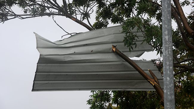
© Richard Polden PerthNowDESTRUCTIVE: A Mini-tornado has left a trail of damage through Canning Vale early today.
A MINI-tornado has ripped through the Perth suburb of Canning Vale early today, damaging houses and cars and removing tiles from roofs.

Several houses have lost roofs and at least one house has lost a pergola which was propelled through a neighbour's car.

McLean Rd, Canning Vale appears to have borne the brunt of the destructive, but small min-tornado.