Earth ChangesS


Arrow Down

US: Massive sinkhole opens up in Daisetta, Texas


Comment: The above is one we missed from 2008, but this report came in today, 12 July 2011:

US: Lenoir, North Carolina sinkhole evidence of a possible wider problem

These reports are from just the past month:

South Carolina, US: Sinkhole Closes Stephens County Boat Ramp

U.S.: Fairfield Township deals with sinkhole

Enormous sinkhole swallows south-east Queensland Rainbow beach

Canada: Downpour Leaves 18-metre Sinkhole in Ontario Highway

Australia: Sinkhole swallows south-east Queensland beach

North Dakota, US: Sinkhole closes Fargo overpass

US: 45' deep sinkhole appears in Pittsburgh parking lot

Big Apple, Cracked! New York, US: Midtown sinkhole stops rush hour traffic, baffles investigators

A collection of sinkhole images from around the world

The planet is literally opening up!


Bizarro Earth

Sicily, Italy: Etna Volcano Erupts Again on July 9 2011

UPDATE 09:45 UTC : Due to the volcanic activity and the ash concentration in the air, the (important) regional airport of Catania was closed since yesterday 18:12 (6:12 PM). The airport reopened this morning at 07:00 ( 7 AM).

UPDATE 08:00 UTC : As stated below, the densely populated Catania area got a lot of ash showers covering cars and roofs with a gray layer.

UPDATE : One video tells more than a 1000 words. This YouTube video was recorded by Klaus Dorschfeldt alias KdEtna. We encourage our readers to take a look at his great Etna Channel on YouTube. The strong eruption was short-lived (see in-depth text below), which explains why there are only daylight videos from this eruption

Cloud Lightning

US: New Mexico Rains Douse Flames But Fuel Flood Fears

The monsoons arrived on schedule in northern New Mexico on Monday, bringing with them the promise of containing a monster wildfire that has broken records in the state.

But they also brought potential peril from flash floods, wind bursts and lightning, with possible flooding made worse by the ground-clearing fires.

"It's such a Catch-22 with the rains," said Arlene Perea, a fire information officer. "The rains are welcome, but we know there are some problems with it."

The National Weather Service on Monday put out a flash-flood watch for the fire area through at least Wednesday. Forecasters said showers and thunderstorms were expected, with hail, lightning and winds up to 45 miles per hour.

Cow Skull

US: Drought Spreads Its Pain Across 14 States

Image
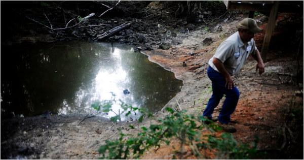
© Grant Blankenship/The New York TimesTerry Pickle climbs out of the hole in Colquitt, Ga., that was once the spot on Spring Creek where river baptisms were held. Drought conditions have reduced the creek to a series of puddles.
Colquitt, Georgia - The heat and the drought are so bad in this southwest corner of Georgia that hogs can barely eat. Corn, a lucrative crop with a notorious thirst, is burning up in fields. Cotton plants are too weak to punch through soil so dry it might as well be pavement.

Farmers with the money and equipment to irrigate are running wells dry in the unseasonably early and particularly brutal national drought that some say could rival the Dust Bowl days.

"It's horrible so far," said Mike Newberry, a Georgia farmer who is trying grow cotton, corn and peanuts on a thousand acres. "There is no description for what we've been through since we started planting corn in March."

The pain has spread across 14 states, from Florida, where severe water restrictions are in place, to Arizona, where ranchers could be forced to sell off entire herds of cattle because they simply can't feed them.

Bizarro Earth

US: Scientists tie Colorado River flooding to San Andreas quakes

Image
© David LynchMap of the San Andreas Fault (Red Line)
Researchers believe Colorado River damming projects that followed the creation of the Salton Sea could be one reason why Southern California is overdue for a major earthquake.

In a new study led by the Scripps Institution of Oceanography, scientists found that the floodwaters that periodically flowed through faults helped trigger earthquakes in the area, including several large ones along the mighty San Andreas.

The modern Salton Sea came to life nearly a century ago when record floodwaters from the Colorado River overwhelmed barriers, and during the course of two years created the massive body of water in a desert sink. Dams and other irrigation barriers were eventually built to stop the flow of water into the sea and end the periodic flooding that had long plagued the area.

But scientists wonder whether the creation of the Salton Sea tweaked the seismic dynamics of the area, which is crisscrossed by numerous fault lines that feed into the San Andreas.

The study's lead author, Daniel Brothers, a marine geophysicist for the U.S. Geological Survey, said that in the past the weight of the flowing floodwaters bent the Earth's crust, causing some sections of the faults to bow and others to bulge. In addition, floodwaters percolated into voids in the rock, exerting an outward pressure on the faults. All this helped trigger quakes, he said.
Bizarro Earth

New Zealand: Christchurch rocked by more than 7400 aftershocks

Image
© NASAChristchurch City
There have been more than 7400 aftershocks in Christchurch in the 10 months since September's magnitude-7.1 quake.

They've sent people running, brought buildings down and left 181 dead.

Many people had been injured, left without water and power - and some have had to abandon their homes.

The aftershocks include the February 22 magnitude 6.3 and the 6.3 tremor which shook the city once again on June 13.

They contribute to this year's total of more than 11,000 quakes felt throughout the country.

Four earthquakes larger than magnitude 6 have already hit New Zealand this year, compared to just three occurring for all of 2010.

Two of them were in Christchurch, one was off the Coromandel coast on January 28 and the largest, a magnitude 6.5, occurred in Taupo last week and was felt throughout the country.

Bizarro Earth

Negros, Philippines - Earthquake Magnitude 6.4

Philippines Quake_110711
© USGSEarthquake Location
Date-Time
Monday, July 11, 2011 at 20:47:06 UTC

Tuesday, July 12, 2011 at 04:47:06 AM at epicenter

Location
9.535°N, 122.175°E

Depth
19 km (11.8 miles)

Region
NEGROS, PHILIPPINES

Distances
125 km (78 miles) W (280°) from Dumaguete, Negros, Philippines

134 km (83 miles) SSW (198°) from Iloilo, Panay, Philippines

150 km (93 miles) SW (215°) from Bacolod, Negros, Philippines

580 km (360 miles) SSE (167°) from MANILA, Philippines

Bizarro Earth

US: Rare, Severe 'Derecho' Windstorm Hits Midwest

Uprooted Tree
© Derrickr_Smg / lockerz.comWoah! A derecho uprooted a huge tree in Chicago, Ill.
A severe storm is sweeping across the Midwest today with winds so strong that it has a special name: derecho.

A derecho (from the Spanish adverb for "straight") is a long-lived windstorm that forms in a straight line - unlike the swirling winds of a tornado - and is associated with what's known as a bow echo, a line of severe thunderstorms. The term "derecho" was first used over a century ago to describe a storm in Iowa. Across the United States, there are generally one to three derecho events each year.

The Midwest derecho has wind gusts between 60 and 80 mph (97 to 129 kph), according to the Weather Channel. Iowa, Wisconsin, Michigan and Illinois have all reported severe winds. These severe winds are the main cause of damage from the storm, said Rose Sengenberger, a meteorologist with the National Weather Service in Romeoville, Ill., but added that people should be on the lookout for other dangerous weather.

"With any long-lived storm, there is also the threat of lightning and heavy rain," Sengenberger told OurAmazingPlanet.

Bizarro Earth

Indonesia Issues Highest Alert for Mt. Lokon Volcano

Mt. Lokon
© Manado Rizky Adriansyah / Tribun ManadoMt. Lokon.
Jakarta - Officials raised the alert for an Indonesian volcano with history of violent explosions to its highest level following a series of eruptions over the weekend.

Disaster managment official Sutopo Purwo Nugroho said Monday people living close to Mount Lokon in north Sulawesi province should be prepared to evacuate if necessary.

Locals and tourists have been urged to stay up to 2.2 miles (3.5 kilometers) away from the 5,741-foot (1,750-meter) volcano.

Radar

Ash from Mount Etna closes Italian airport

Image
© Unknown
A southern Italian airport was on Saturday closed due to ash from Mount Etna, forcing traffic to be diverted to Palermo, the ANSA news agency said.

Catania airport on the east coast of the island of Sicily was not expected to re-open before Sunday morning while the runway was cleared, the report said.

The volcano, which currently does not present any risk to local residents, spewed lava on to its southeastern slopes on Saturday afternoon and winds carried the ash further afield.

Etna is the highest active volcano in Europe at 3,295 metres (10,810 feet). The last eruption was in May.

A massive flood of meltwater from Iceland's Myrdalsjoekull glacier, meanwhile, has raised fears of an eruption from the powerful Katla volcano there.