Earth ChangesS

Cloud Lightning

Canada: Wet Weather Affects Prairie Wheat Seeding

wheat field
© Chris Bergin/The Star Press/Associated PressThe Wheat Board says seeding is about 86 per cent complete across the Prairies when usually by this time of year, it is entirely done.
The Canadian Wheat Board says this year could be even worse than 2010, sucking an additional $1.5 billion to $2.5 billion out of the Prairie economy.

On Tuesday, the board said between 2.4 and 3.2 million hectares of farmland is still unseeded across the Prairies this year because of wet weather.

"This is occurring at a time when grain prices are extremely high, adding insult to injury," said Bruce Burnett, the board's director of weather and market analysis.

"Many farmers in the wettest areas have planted next to nothing this spring, while others are watching their newly emerged crops drown," Burnett said.

The seeding estimate is only marginally better than last year - another wet planting season - which set a record low that stretched back to 1971.

But Burnett also forecast yields that could be lower than last year due to other factors, such as an even later start to seeding this season.
Cloud Lightning

Rain-triggered floods, landslides leave 105 dead, 63 missing in south China

Image
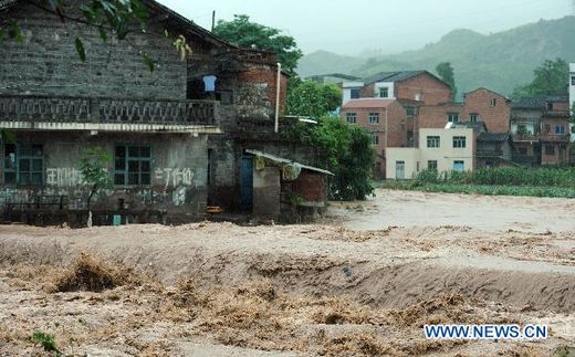
© News.cnReference image from July 10, 2010 flooding in S. China.
Beijing, - Rain-triggered flooding and landslides in south China have left 105 people dead and 63 more missing over the past 10 days, the Ministry of Civil Affairs said Monday.

According to the official count, as of 10 a.m. Monday, the rain-caused disasters that occurred since June 3 have left 39 people dead and 21 more missing in Hunan Province as well as 29 dead and 10 missing in Hubei Province.

While in Guizhou Province 24 people died and 32 were missing and in Jiangxi the death-toll stood at 13, according to the ministry.

Prior to the rain, the provinces of Hubei, Hunan and Jiangxi -- located along the middle and lower parts of the Yangtze River basin -- were stricken by a prolonged drought.

The ministry along with the National Disaster Reduction Commission on Monday launched an emergency response in anticipation of more downpours in central and southern China over the next few days.

Meanwhile, they ordered relief-supply reserve stations in 11 provinces and seven cities in these regions to gear up for the expected downpours.

Local civil affairs departments were told to enhance measures and work closely with other related departments to prevent flooding, geographical disasters and other secondary disasters, which may be triggered by the rainfall.

They were also told to help people by launching safety inspections, setting up temporary shelters, making emergency plans, and evacuating people in the most dangerous areas.

Cloud Lightning

US: Missouri River states brace for floods

Omaha
Image
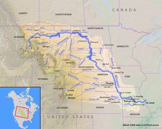
© UnknownStates Along/Bordering the Missouri River.
- The scramble is nearly over to fill thousands of sandbags and construct last-minute levees to heights that have not been needed in decades, but those preparations were only the first round of what is likely to be a summerlong battle against the bloated Missouri River.

Peak flows are expected to arrive early in the week in riverfront communities in Iowa, Kansas, Missouri, and Nebraska as the Army Corps of Engineers completes a gradual increase of releases from dams upstream. The surge through the lower half of the river this week will expose any weaknesses in the flood protections.

"They're going to be as prepared as they can be,'' said John Benson, spokesman for Iowa's Department of Homeland Security and Emergency Management Division.

The Corps said this summer's Missouri River flooding could rival the record years of 1952 and 1993 in some places. Tomorrow, officials will increase releases from five of the river's dams to 150,000 cubic feet of water per second - more than twice the previous record releases.

As a result, the river will rise 5 to 7 feet above flood stage in most of Nebraska and Iowa before moving into Missouri, where it may rise 10 feet above flood stage in several places.

Bizarro Earth

US: Fires and Floods Threaten Parts of Colorado

High-country residents may nervously watch snow melt and rivers rise this week, as smoke from distant fires continues to choke parts of Colorado, authorities said Sunday.

Cooler temperatures this weekend slowed the melt of a still-abundant snowpack, according to the National Weather Service. However, temperatures are on their way up again.

"As temperatures continue to be above normal, mountain snowmelt is expected to accelerate again," the National Weather Service said Sunday. "Mountain streams will continue to see high streamflows through the end of the week."

Jackson County is under a flood warning until 1:30 p.m. Tuesday, and Grand County is under a flood advisory until noon Tuesday.

Colorado's snowmelt usually peaks by mid-June, but only about 45 percent of snowpack in some areas has melted this year, forecasters said.

Smoke continues to suffocate other parts of Colorado.

Cloud Lightning

India: Strong Winds Forecast in South Gujarat

Image
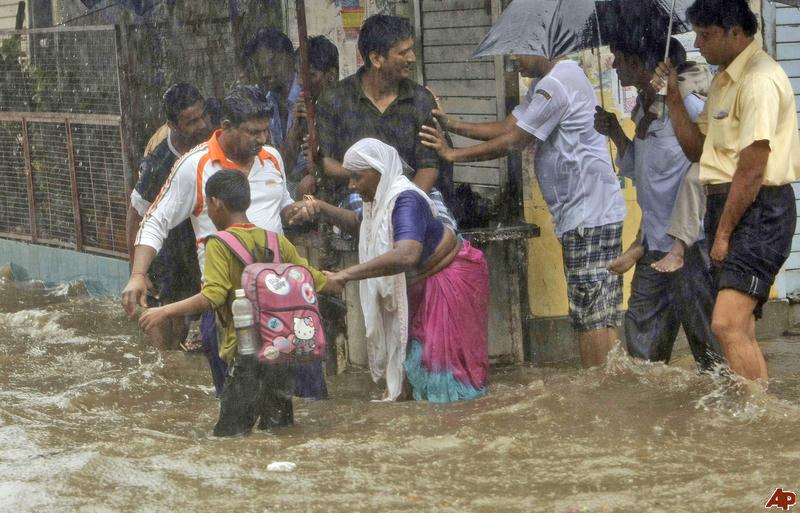
© The Associated Press / Rajanish KakadeA boy helps an elderly woman cross a waterlogged street as it rains in Mumbai, India, Saturday, June 11, 2011. Heavy rains continued to lash the city for the third consecutive day Saturday, causing waterlogging in several parts of the city.
India Meteorological Department (IMD) has advised fishermen not to venture into sea during the next 24 hours and asked the ports in south Gujarat to hoist local coastal signal (LCS) III, indicating rough weather and strong winds.

In Junagadh, lightning killed three people, including two children in the Uparkot, as Saurashtra experienced heavy rains on Saturday and Sunday. Junagadh district received maximum rains.

Heavy rains also lashed Rajkot city, uprooting electric poles and trees. Areas like Shubhashnagar, Astron chowk and Kotharia Road remained water logged.

Strong winds with speed of 45-55 km/h and reaching occasionally up to 65 km/h will continue along and off Maharashtra and south Gujarat coasts.

"Sea condition will be rough. Fishermen are advised not to venture into the sea during next 24 hours," the IMD said. Heavy to very heavy rains are expected in few places in Saurashtra, Kutch and Diu in the next 24 hours.

Cloud Lightning

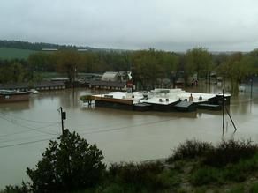
US: Flooding, Heavy Rain Delays Planting for Hundreds of Thousands of Acres

Image
© Montana News
For years, Gordon Stoner's rule for keeping the rain-soaked Northeast Montana soil from swallowing his tractor was to "turn when the ducks fly," meaning nothing short of a pond would cause him to turn the wheel.

Then the record rains of 2011 turned his fields to soup and kept his tractor in the barn for all but 41 hours over a three-week stretch in May. When he finally got into the field, his tractor's heavy wheels flattened the fooded groundhog tunnels below. Water shot like geysers from the prairie dog holes.

"I have never entertained the thought of not getting a crop in," Stoner said. "You eat an elephant one bite at a time. You just gnaw away at it, but we've got rain in the forecast and if we get much more, I don't know."

It takes a lot to get a Montana farmer to curse the rain, but some are beginning to. Hundreds of thousands of acres have gone unplanted due to unprecedented rains and the number of growing days needed to produce a crop is quickly dwindling. In addition, federal officials now estimate 1.4 million Montana acres-an area slightly larger than Glacier National Park-has been hit by flooding.

Cloud Lightning

US: The Last 'Big One': Remembering the Flood of '52

Image
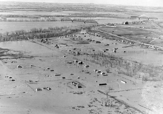
© TRIBUNE filesFlooded south Bismarck in April of 1952.
The 2011 Missouri River flood certainly will go down as "the big one" in many respects. But major flood events on the river in Bismarck and Mandan are not unprecedented

In 2009, an ice jam in the river caused water to back up. In 1952, a similar scenario played out, hitting the cities hard and fast with no warning.

There was no Garrison Dam in 1952. The only dam on the Missouri River system then was the Fort Peck Dam in Montana but downstream, the Milk River and other tributaries had no dams to hold back the water.

The 1952 flood hit Bismarck and Mandan on April 6, a Sunday morning when many people had yet to return home from church services.

Jim Davis, head of reference of the state archives at the State Historical Society of North Dakota, compiled some data from Bismarck Tribune files and other sources on that flood.

The latest projection for the Missouri River is to crest somewhere between 19 and 19.6 feet.

In 1952, the river hit 27.8 feet. Similar to 2009, an ice jam caused that flood, leaving the water with nowhere to go except into neighborhoods on both sides of the river.

Bizarro Earth

Eritrean volcanic ash cloud heading toward Israel

volcanic ash cloud
© AP
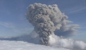
A volcanic ash cloud created after a volcano erupted in the northern African country of Eritrea is heading toward Israel, the Israel Meteorological Service confirmed on Tuesday.

It is not yet certain whether the cloud will disrupt flights in the area.

According to current estimations, the ash cloud is moving high in the atmosphere, and will probably remain too high to cause any travel disruptions or changes in the quality of air.

Attention

US: Windsor, Pennsylvania, Tornadoes did hit on Sunday

windsor PA tornado
After spending the weekend in Wildwood Crest, New Jersey, Kris and Luanne McNew returned to their Windsor Township home Sunday night to downed trees and power lines along their wooded property.

More than three decades ago, they opted to build their two-story home in the 600 block of Bahns Mill Road, which is surrounded by woods, said Luanne McNew.

And during all their years spent in the home, a tree never fell onto their home or property, said McNew.

That changed Sunday, after a tornado touched down in Windsor Township.

Sun

Sun's Fading Spots Signal Big Drop in Solar Activity

Sun Spot
© The Royal Swedish Academy of Sciences, V.M.J. Henriques (sunspot), NASA Apollo 17 (Earth)A photo of a sunspot taken in May 2010, with Earth shown to scale. The image has been colorized for aesthetic reasons. This image with 0.1 arcsecond resolution from the Swedish 1-m Solar Telescope represents the limit of what is currently possible in terms of spatial resolution.

Some unusual solar readings, including fading sunspots and weakening magnetic activity near the poles, could be indications that our sun is preparing to be less active in the coming years.

The results of three separate studies seem to show that even as the current sunspot cycle swells toward the solar maximum, the sun could be heading into a more-dormant period, with activity during the next 11-year sunspot cycle greatly reduced or even eliminated.

The results of the new studies were announced today (June 14) at the annual meeting of the solar physics division of the American Astronomical Society, which is being held this week at New Mexico State University in Las Cruces.

The studies looked at a missing jet stream in the solar interior, fading sunspots on the sun's visible surface, and changes in the corona and near the poles.

"This is highly unusual and unexpected," said Frank Hill, associate director of the National Solar Observatory's Solar Synoptic Network. "But the fact that three completely different views of the sun point in the same direction is a powerful indicator that the sunspot cycle may be going into hibernation."