Earth ChangesS


Bizarro Earth

Solomon Islands - Earthquake Magnitude 6.6

SOlomon Islands quake_060311
© USGSEarthquake Location
Date-Time:
Monday, March 07, 2011 at 00:09:38 UTC

Monday, March 07, 2011 at 11:09:38 AM at epicenter

Time of Earthquake in other Time Zones

Location:
10.334°S, 160.739°E

Depth:
37.9 km (23.6 miles)

Region:
SOLOMON ISLANDS

Distances:
127 km (78 miles) W of Kira Kira, San Cristobal, Solomon Isl.

135 km (83 miles) SE of HONIARA, Guadalcanal, Solomon Islands

176 km (109 miles) S of Auki, Malaita, Solomon Islands

2064 km (1282 miles) NNE of BRISBANE, Queensland, Australia

Bizarro Earth

Hawaii: Lava spews 65 feet high after crater collapse

Kilauea, Volcano
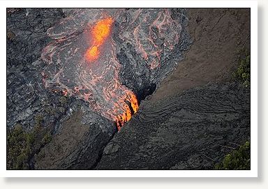
© Tim Wright - APLava flows on the Pu'u O'o crater on Kilauea Volcano on Sunday, March 6, 2011 in Hawaii. Scientists say the Pu'u O'o crater floor has collapsed and an eruption occurred along the middle of Kilauea Volcano's east rift zone. Scientists at the Hawaiian Volcano Observatory say after a fissure broke out around 5 p.m. Saturday, lava was seen erupting up to 65 feet high.
A new vent has opened at one of the world's most active volcanoes, sending lava shooting up to 65 feet high, scientists at Kilauea volcano said Sunday.

The Hawaiian Volcano Observatory said the fissure eruption was spotted shortly after the floor at the Pu'u O'o crater collapsed around 5 p.m. Saturday. It occurred along the middle of Kilauea's east rift zone, about 2 miles west of Pu'u O'o.

"As a volcanogist, this is what we do. These are the moments we wait for," volcanogist Janet Babb told KHON2. "It is exciting to see an eruption begin particularly if you can see it from the very start."

Eye 1

Two Suns in Manchester?

Is this a sun dog?

Image

Question

Two Suns in Russia?

Two suns or sun dog?

Image

Bizarro Earth

Iceland: Earthquake Activity Increases Again in Krýsuvík Volcano

It appears that Krýsuvík volcano earthquake activity is increasing again. This time around it appears that the earthquake activity in Krýsuvík volcano has moved more to the west then last weeks earthquake activity.

The biggest earthquake so far is a ML2.1 earthquake with the depth of 6.9 according to automatic data on Icelandic Met Office web page.

Volcanic Activity
© Icelandic Met Office.
The new earthquake area in Krýsuvík volcano. It is more to the west then the earthquake area that was making earthquakes last week. Activity appears to be picking up slowly. But it is hard to know how this develops over the next few hours or days.

Bizarro Earth

Japan: 50 Melon-Headed Whales Stranded on Ibaraki Shore; 22 Rescued

Melon Headed Whales
© Robin W. BairdThree melon-headed whales.

Mito - About 50 melon-headed whales were found to have beached on the shore in Kashima, Ibaraki Prefecture, in eastern Japan Friday night and 22 were rescued and returned to the sea on Saturday by authorities and local volunteers.

About 200 people, including staff at Oarai Aquarium in the same prefecture, city government officials and local residents and surfers near the Oritsu coast tried to save the beached whales by keeping them hydrated while they tried to refloat them, but 30 of them died, according to the city government.

It took about eight hours to return the surviving whales to the sea, the officials said, adding they have buried the carcasses of the dead whales on the nearby shore.

Melon-headed whales are commonly seen offshore around the area in the early spring and they may have been drawn into the shallow waters while following their food, said Masayuki Shimada, chief of the marine animal exhibition section of the aquarium.

Bizarro Earth

First Look at New Volcano Fissure Erupting in Hawaii

New fissure eruption
© Big Island Video News
The geologists with the USGS Hawaiian Volcano Observatory have released a first look at the new fissure eruption that just started today between Pu'u 'O'o and Napau Crater.

According to geologists, the first portion of the video was shot from the air looking southwest at the fissure eruption between Pu'u 'O'o and Napau Crater. The fissure segment in the tephra in the foreground opened seconds earlier, and only about 10 minutes after the eruption as a whole started. The cracks through the tephra are in the process of opening, though this can't be picked out at this distance.

The second part of the video was shot from the ground in front of the propagating fissure, showing low spattering that started moments earlier. Thick white steam from the crack in the foreground indicates that lava is about to reach the surface, and is seen doing so seconds later.

Cloud Lightning

US: Mom sheltering child dies as tornado hits Louisiana town

Image
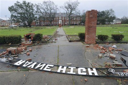
© AP Photo/The Lafayette Daily Advertiser, P.C. PiazzaDebris litters ground in Rayne, La., after a suspected tornado hit the area injuring at least nine people, leveling homes and causing natural gas leaks that prompted evacuations on Saturday, March 5, 2011.
Rayne, Louisiana - When the tornado hit this Louisiana town, Jalisa Granger was instinctively sheltering her child from the sudden, fierce winds. Pieces of homes shot skyward, debris lodged in treetops and a U.S. Postal Service truck was flipped on its side.

When it was over, the 21-year-old mother lay dead from a tree that had fallen on top of her home, authorities say. But her child survived the tornado's rampage through Rayne, a south Louisiana community of 8,500 people some 70 miles west of Baton Rouge.

Maxine Trahan, a spokeswoman for the Acadia Parish Sheriff's Office, said Granger was protecting her child when the tornado hit.

"She sheltered the child to protect her from the storm and a tree fell on the house and it killed the mother but the child was OK," Trahan said. A relative who lived nearby found the woman.
Bizarro Earth

Earthquake Magnitude 6.5 - South Sandwich Islands Region

South Sandwich Islds Quake_060311
© USGSEarthquake Location
Date-Time:
Sunday, March 06, 2011 at 14:32:36 UTC

Sunday, March 06, 2011 at 12:32:36 PM at epicenter

Time of Earthquake in other Time Zones

Location:
56.406°S, 27.029°W

Depth:
86.9 km (54.0 miles) set by location program

Region:
SOUTH SANDWICH ISLANDS REGION

Distances:
33 km (20 miles) NNE of Visokoi Island, South Sandwich Islands

293 km (182 miles) N of Bristol Island, South Sandwich Islands

2066 km (1283 miles) ESE of STANLEY, Falkland Islands

3408 km (2117 miles) SE of BUENOS AIRES, D.F., Argentina

Bizarro Earth

Chile: Earthquake Magnitude 6.2 - Tarapaca

Tarapaca Quake_060311
© USGSEarthquake Location
Date-Time:
Sunday, March 06, 2011 at 12:31:57 UTC

Sunday, March 06, 2011 at 09:31:57 AM at epicenter

Time of Earthquake in other Time Zones

Location:
18.115°S, 69.391°W

Depth:
101.3 km (62.9 miles) set by location program

Region:
TARAPACA, CHILE

Distances:
92 km (57 miles) E of Tacna, Peru

108 km (67 miles) ENE of Arica, Tarapaca, Chile

193 km (119 miles) ESE of Moquegua, Peru

1704 km (1058 miles) N of SANTIAGO, Region Metropolitana, Chile