Earth ChangesS


Wolf

Paterson man savagely attacked by his own pit bull terrier

Image
Bitten on his face, arm, stomach and back, a 35-year-old Paterson man said he crawled out of his Albion Avenue home early Sunday morning to escape the four-year-old pit bull he had raised as a puppy.

The victim, Juan Cay, said the dog turned on him during a domestic argument involving his wife and her uncle. "I was frightened for my life," said Cay. "I thought that dog was going to kill me."

Cay said that at one point during the attack his wife confined the dog in a bedroom, but the animal broke out and went after him again. Cay said his wife again managed to get the dog into a different room. "I crawled out and passed out on the sidewalk," said Cay.

Cay was treated at St. Joseph's Regional Medical Center, authorities said. The victim said he likely will need surgery to repair damage to his arm.

Windsock

Data indicates pattern of fewer tornado days in U.S. - but more tornados!

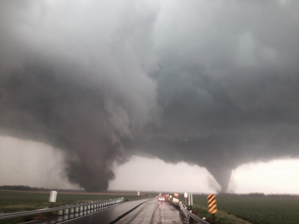
Twin Tornadoes
© Matt CokerEmerging pattern: fewer tornado days in U.S. - but more tornados!
A trio of researches with the U.S.'s National Oceanic and Atmospheric Administration (NOAA) has found that though there are fewer total days per year when tornados occur in the U.S., the number that occur on days when there are tornados has increased over the past couple of decades. In their paper published in the journal Science, Harold Brooks, Gregory Carbin and Patrick Marsh describe how they studied weather data over the past half century and what they found when looking for trends.

Tornados happen in many places, but because of its unique geography, the U.S. has more than any other country - mainly due to the lack of a large mountain dividing east and west. There has been speculation recently, that global warming is causing more tornados to occur - though it has also been suggested it only seems that way because of how quickly information about tornadic events disseminates in the modern era. The trio at NOAA decided to let hard facts tell the story. They collected weather data from the national storm database, which goes back to 1954, to see if they could coax out any patterns (they only included tornados at least as strong as an F1).

Comment: see also: US study finds tornadoes coming in swarms rather than isolated occurrences and
SOTT Earth Changes Video Summary - September 2014


Snowflake

Siberian snow cover far ahead of schedule - near record pace

Image
The difference is massive.
...................................................................................................................................

Compare snow mapping for October 2013 and October 2014

....................................................................................................................................

NSIDC Snow Cover showing Siberian Snow Extent 2004-2014

Quoting WxRisk, "not only is the SAI way ahead of schedule and at a near record pace BUT the SCE - snow cover extent - is also going Gang busters.."

Thanks to Caroline Snyder in West Virginia for these links
"And we know that Siberian Ice Extent influences the severity of North American winters," says Caroline.

Bizarro Earth

Hurricane Ana floods roadways putting Hawaii's Big Island under Flash Flood Warning

Image
Flash Flood Warning

The National Weather Service in Honolulu has issued a Flash Flood Warning for the Big Island until 12 noon Saturday (Oct 18). At 9 a.m. rain gages at Kulani Cone above Glenwood showed heavy rain falling at two inches per hour. This area of heavy rain was nearly stationary. The heavy rains will continue to stream into the Ka'u and Puna districts over the next two to three hours.

The Hawaii Police Department reports that Highway 11 between the 57 and 58 mile marks between Pahala and Naalehu is closed to all traffic due to flooding. Motorists are advised to avoid the area and to use alternate routes if possible.

Campers and hikers should avoid low lying flood prone areas. People should stay away from streams, drainage ditches and low lying areas prone to flooding. The rainfall and runoff will cause hazardous driving conditions due to ponding, reduced visibility and poor braking action.

Windsock

80% of Bermuda without power as Hurricane Gonzalo hits

Hurricane Gonzalo
© Nicola Muirhead/ReutersBermuda's south shore is battered by heavy winds from Hurricane Gonzalo, which pounded the British territory Friday evening.
Hurricane Gonzalo has hit Bermuda, cutting power to many residents.

The category 2 hurricane caused flooding, felled trees, knocked down power lines and damaged buildings, including the island's main hospital.

Wind speeds of up to 175km/h (110mph) were reported, making it the strongest storm to hit the British overseas territory in a decade.

However there were no reports of deaths or serious injuries and emergency services are now clearing the wreckage.

Attention

Birds fall dead from sky in Bapunagar, India

crow
It's a sight that would send shivers down most people's spines -- dead birds plummeting from above for no apparent reason. Nearly 50 crows and eagles were found dead around Lal Bahadur Shastri Stadium in Bapunagar on Friday morning. When they first realised what had happened, residents in the areas were, understandably, left baffled by the necrotic avian rain. They said it was like something out of a horror film.

"The birds would get up and try to fly, go out of control and crash again. It was just strange," they said. Concerned residents called the forest department as well as the animal help organizations. However, forest officials refused to come claiming this was not under their jurisdiction, said residents. Manoj Bhavsar of Jeevdaya Charitable Trust, one of the organizations that reached the spot, said, "We received a call saying they spotted 7-8 dead birds in the area. Soon, we got a couple of other calls that more birds have been found dead or in a weak condition.

Cloud Lightning

Tropical storm Trudy forms off Mexico's Pacific coast; flash floods and mudslides forecasted

rainfall tropical strorm trudy
Tropical storm Trudy formed off Mexico's Pacific coast late on Friday, the U.S. National Hurricane Center said in a statement forecasting life-threatening flash floods and mudslides in southern regions of the country.

The storm, which was headed north at about 5 miles (7 km) per hour, was about 85 miles (140 km) southeast of the beach resort of Acapulco on Friday evening and expected to make landfall in southern Mexico on Saturday.

With sustained winds of nearly 40 mph (65 km/h), Trudy is expected to dump 6 to 12 inches (15-30 cm) of rain on the southern states of Guerrero and Oaxaca over the next few days.

The storm could strengthen before making landfall, when it is expected to weaken.

Cloud Precipitation

Flooding in Galicia, Spain - Vigo under 40cm of water

Image
© Oscar Vázquez
The city of Vigo in Galicia, Spain, is still under water after heavy rain has battered the region since 16 October 2014. WMO reports that the city saw 81 mm of rain fall in 24 hours between 16 and 17 October 2014.

Emergency teams from Protección Civil were called out on at least 20 occasions. The worst affected areas were the central parts of the city and also around the Balaídos football stadium. Numerous roads around the coty have been blocked by flood water around 40 cm deep. Not only did he flooding stop traffic, it also stopped car production in the city's Citroen car plant. Trains and ferry services have also been affected.

The storm has left over 9,000 without power.


Cloud Precipitation

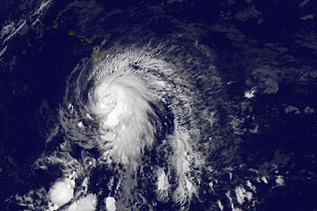
NASA satellites sees a question mark in Tropical Storm Ana as it approaches Hawaii

Storm Ana
© NASANOAA's GOES-East satellite captured this image of Tropical Storm Ana approaching Hawaii in the Central Pacific Ocean on Oct. 17 at 1500 UTC (11 a.m. EDT).
NOAA's GOES-West satellite captured an image of Tropical Storm Ana that showed the outer clouds were already reaching the big island by 11 a.m. EDT and the storm resembled a giant question mark.

Tropical Storm Ana was nearing hurricane strength mid-day on Oct. 17 and the Central Pacific Hurricane Center (CPHC) expects the storm to become a hurricane before reaching the big island of Hawaii.

NOAA's GOES-West satellite took an infrared picture of Tropical Storm Ana as it was approaching Hawaii on Oct. 17 at 11 a.m. EDT (5 a.m. HST). Ana looked like a giant question mark in the infrared image, as a large band of thunderstorms wrapped into the center from the eastern side of the storm and extended south of the storm.

Despite the storm looking like a question mark from space, the Central Pacific Hurricane Center said that there is no question the storm has been intensifying.

Health

Cox Hospital Springfield sees increase in dog attacks, Missouri

Image
Most serious cases involve children.

They're called man's best friend, but dogs also have the potential to be dangerous. Cox Hospital has seen an alarming rise in serious dog bites this year - most of them involving children.

It's not unusual for the Cox South Emergency Room to treat dog bites, but doctors say they've seen an increase in life threatening dog attacks. More children have been admitted to the hospital than usual, and some were even placed in critical condition.


Here's a look at the numbers:

Comment: See also: Dog attacks surging in Yarra Ranges, Australia

Indore reports at least 50 dog bite cases daily, India

Nine people killed by feral dog attacks in Rumbek, Sudan

Modesto, California: Vicious dogs roaming streets, chasing people and trapping them inside homes