Earth ChangesS


Info

Ash Cloud Forces Barcelona to Leave Early for Champions League Final

Image
© David Ramos/Getty ImagesAndrés Iniesta and Victor Valdes in training for Barcelona's Champions League final against Manchester United.
Barcelona will travel to London on Tuesday evening because of fears of volcanic ash from Iceland drifting towards England ahead of Saturday's Champions League final.

The Spanish champions were due to head to England on Thursday for this weekend's showpiece at Wembley against Manchester United but have opted to arrive two days ahead of schedule. The club said: "To avoid possible disruption due to ash from the volcano Grimsvotn, the Barça first team will travel to London today at 22:00hrs."

The Barça spokesman, Toni Freixa, will appear at a press conference at Camp Nou at 5pm local time to provide further information to supporters. The eruption of Grimsvotn has led to airlines cancelling flights to and from Irish and Scottish airports.

The Barcelona coach, Pep Guardiola, said on Monday that his team were prepared to alter their travel plans to reach the European final if obliged to do so. Guardiola spoke of his concerns over disruption that could be caused to the fans - many of whom will travel on the day of the match - and promised the Catalan club would take every precaution.
Cloud Lightning

US: 29,000 without power after storm slams southeast Michigan

Image
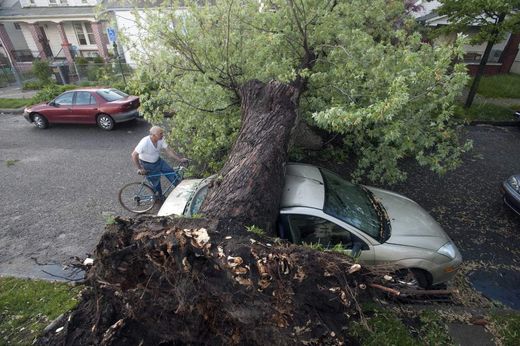
© David Guralnick / The Detroit NewsTom Micoli checks out a maple tree downed Monday by a storm on Burnside in Detroit. The harsh weather snapped tree limbs and knocked down wires around the Metro area, leaving thousands without power.
The severe weather that knocked out power to thousands, toppled tree limbs and felled power lines may have fizzled out Monday night, but that doesn't mean Metro Detroit is done with wet weather through the start of the holiday weekend.

"It looks like it's going to continue to be rainy for this week," said Amos Dodson, a meteorologist for the National Weather Service.

NWS said there's a 30 percent chance of showers today, with highs in the 60s and lows in the 40s. Another system brings showers and thunderstorms Wednesday, and rain is also in the forecast through Friday

Cloud Lightning

US: In Minneapolis, storm toll quietly rises

Joplin, Mo., continues to dig out from the massive tornado that blasted the city Sunday, but it wasn't the only city hit hard that day. Minneapolis-based Finance and Commerce reports that officials there are dealing with a "very preliminary" estimate of $166 million in damage to homes, buildings and infrastructure.


Info

US: Heavy Rains Cause Major Flooding Across Northeast Oklahoma


Heavy rains have caused major flooding in many locations across Northeast Oklahoma.

Nearly ten inches of rain have fallen near Vinita. That's where SkyNews6 found three men rescuing a woman in a stranded vehicle. The video shows one man breaking a window to help get the woman out. The men then helped her wade through the water to safety.

News On 6 reporter Ashli Sims captured video of flooding along I-44 southwest of Miami. Flooding forced Miami Public Schools to cancel classes Tuesday.

Rising waters also caused problems in Muskogee. The Muskogee Police Department told News On 6 officers performed several vehicle rescues Monday evening.

Cherokee County Emergency Management said it had also received reports of significant flooding. Officials there said at least three water rescues were performed Monday, but no one was injured. Power lines and trees are down across Cherokee County.

Cloud Lightning

Philippines: Update Chedeng picks up strength as it nears land; storm warnings up

Image
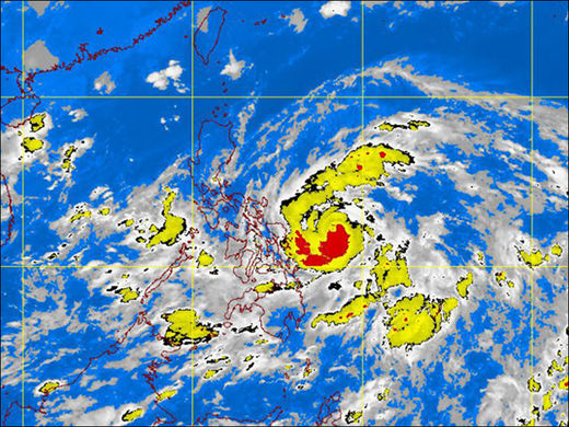
© Graphics from http://www.pagasa.dost.gov.phPAGASA-DOST MTSAT-EIR Satellite Image for 5 a.m., 25 May 2011
Tropical Storm Chedeng continued to bear down on the Philippines with greater force Tuesday, compelling the weather bureau to issue warnings in seven provinces in the Bicol and Eastern Visayas regions that were already beginning to feel the effects of the country's third cyclone this year.

As of 10 a.m. Tuesday, the Philippine Atmospheric, Geophysical, and Astronomical Services Administration (Pagasa) said, Chedeng was located 490 kilometers east of Borongan, Eastern Samar, with maximum sustained winds of 105 kilometers per hour near the center and gusting up to 135 kph.

Umbrella

US: Flooding grows near Brownville; rain begins in west

Image
Umbrellas were the order of the day for Nebraskans from west to east Tuesday, with heavy rain predicted across much of the state. Some storms could also turn severe, with large hail possible and some isolated tornadoes in far southeast Nebraska, the National Weather Service said.

Already Tuesday morning, 1.25 inches of rain had fallen in Red Cloud near the Kansas border. And overnight rains added as much as 2 inches of rain to already soggy soil in southwest and west-central Nebraska.

Rain totals included: Imperial, 2.04 inches; Wauneta, 1.94; Wellfleet, 1.17; Hayes Center, 1.09; Curtis, 0.97; Moorefield, 0.92; Swan Lake, 0.75; Oshkosh, 0.73; North Platte, 0.71.

The North Platte area is under a flood warning and flash flood watch, bracing for 2-4 more inches of rain. The North Platte River is already at a record level, with overflows expected to increase at least through Friday.

Cloud Lightning

US: Climatologist warns of potential floods

A rogue jet stream is responsible for causing severe weather since the fall - including Sunday's devastating tornado in Joplin, Mo. - and could trigger severe flooding in the West, a JPL climatologist warned Monday.

Bill Patzert of the NASA's Jet Propulsion Laboratory in La Ca ada Flintridge said he is "extremely anxious" about the possibility of floods that could arrive in late spring and early summer in the West.

"Especially on the Sacramento and San Joaquin rivers" and the upper Colorado River, he said.

Bizarro Earth

Fears of repeat disaster as fires rage in Russian east

Image
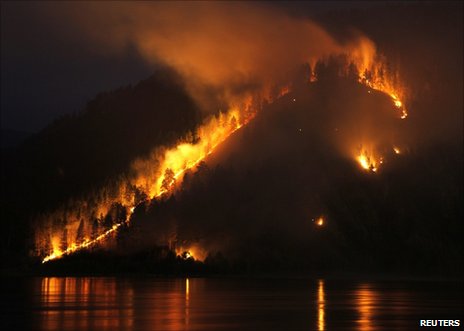
© ReutersSo far the fires are confined to eastern Russia
Russia has reported 421 wildfires burning in forests and peat bogs over the past 24 hours, covering an area of 116,098 hectares (450 sq miles).

The fires were mainly confined to remote parts of Siberia and the Urals, with no blazes reported near Moscow and other central Russian cities.

But the area on fire is twice the size of that for the same period last year.

Drought, fires and smog left dozens dead and ruined crops in 2010, and there are fears of a repeat disaster.

The emergencies ministry said in a report on its website that the biggest fires were in the Sakha Republic (Yakutia), the Amur region and the Krasnoyarsk territory.

More than 6,000 personnel equipped with more than 1,140 units of fire-fighting equipment were deployed against the fires, backed by 42 aircraft.

Of the 421 fires reported on Monday, 241 were extinguished, the ministry said.

Western Russia, the centre of the country's grain production, remains largely unaffected by fire, but officials say the situation may deteriorate if dry weather persists.

Russia's official forecast for this year's wheat crop is 85-90m tonnes compared to some 61m in 2010, 97m in 2009 and 108m in 2008.

Meanwhile, drought conditions have been hitting grain crops in northern Europe, with some forecasters predicting above-average temperatures for the summer months.

Attention

US: Heavy Rains Cause Mudslide in Maple Grove; Minnesota

A mudslide has closed a road in Maple Grove in the northwestern Twin Cities.

Hennepin County officials say an emergency closure is in place on Bottineau Boulevard from 93rd Avenue North to Fernbrook Lane.

Heavy rains and storms over the weekend caused the mudslide.

Crews are working to remove the mudslide so one lane in each direction will be open by Monday evening. Residents are encouraged to find alternate routes.

Cloud Lightning

US: National Weather Service warns more rain could bring floods to western Montana

Officials are keeping a close eye on both the rivers and the sky this week, as they track several weather systems predicted to bring rain and more flood worries to western Montana.

The National Weather Service issued flood watches for Missoula and Ravalli counties Monday afternoon in anticipation of overnight rainshowers.

Severe flooding in eastern Montana caused road closures and evacuations as the week began, prompting Gov. Brian Schweitzer to issue a statewide flood emergency declaration. Missoula, Ravalli, Sanders, Lincoln, Glacier and Lake counties were all included in the declaration.

The Weather Service issued a flood warning for the Clark Fork River above Missoula as well. The river rose to 9.3 feet Monday and is forecast to reach its 10-foot flood stage by Tuesday morning.

"The area that looks like it will go to flood probably quicker than anything is the Clark Fork River in Missoula. How fast and how much it rises will depend on how much precipitation falls. This forecast could change as we go into the week," said Ray Nickless, hydrologist for the Weather Service.