Earth ChangesS


Snowflake

Minnesota still has snow on the ground from last winter

Image
© Chris Kuball, ABC 6
There is still snow on the ground in southern Minnesota.

You read that correctly. ABC 6 Meteorologist Chris Kuball tweeted a photo of a snow pile, that looks more like a rock, at Marcusen Park in Austin, Minnesota, Monday morning.

The park is a dumping site for snow in the area, Kuball says, and on June 23 there was still a pile of snow that was about 10 feet tall, 50 feet long and 30 feet wide, Kuball said in a Facebook post.

Check out this then-and-now photo:
Image

Comment: Many areas have been experiencing the lingering effects from last winter.

See related:


Attention

8.0-Magnitude Alaska earthquake prompts tsunami advisory for Pacific Coast

Image
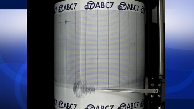
© ABC7The ABC7 Quake Cam shows an 8.0-magnitude earthquake that struck Alaska on Monday, June 23, 2014.
An 8.0-magnitude earthquake struck at 1:53 p.m. in Alaska, prompting a tsunami warning for the U.S. Pacific coast. A preliminary report indicated the quake was a 7.1 magnitude. That was revised minutes later to 8.0 by the U.S. Geological Survey.

The warning for Southern California was downgraded to a tsunami advisory by the National Weather Service.

The NWS reported that water was leaving the harbor of the city of Adak, Alaska, at 3:23 p.m. The Adak city manager confirmed to ABC News that water in the harbor was receding and people in that area were heading for higher ground.

The earthquake struck 244 miles southeast of Attu Station in Alaska, about 15 miles off Little Sitkin Island.

The earthquake occurred at a depth of 71.1 miles, according to the USGS.

Comment: The Aleutian volcanoes in Alaska are waking up and showing more activity than has been seen for decades in an already volatile region. The Pacific Ring of Fire has been quite active this year and will certainly be something to watch.

See related:


Bizarro Earth

USGS: Earthquake Magnitude 6.9 - 96km SSE of Raoul Island, New Zealand

Raoul Island Quake_230614
© USGS
Event Time
2014-06-23 19:19:16 UTC
2014-06-23 07:19:16 UTC-12:00 at epicenter
Location
30.118°S 177.670°W depth=20.0km (12.4mi)

Nearby Cities
96km (60mi) SSE of Raoul Island, New Zealand
973km (605mi) NE of Whangarei, New Zealand
999km (621mi) NNE of Whakatane, New Zealand
1014km (630mi) NE of Tauranga, New Zealand
1025km (637mi) SSW of Nuku'alofa, Tonga

Scientific Details

Bizarro Earth

USGS: Earthquake Magnitude 7.9 - 24km SE of Little Sitkin Island, Alaska

Alaska Quake_230614
© USGS
Event Time
2014-06-23 20:53:10 UTC
2014-06-23 11:53:10 UTC-09:00 at epicenter

Location
51.797°N 178.759°E depth=114.4km (71.1mi)

Nearby Cities
24km (15mi) SE of Little Sitkin Island, Alaska
1370km (851mi) E of Petropavlovsk-Kamchatskiy, Russia
1387km (862mi) E of Vilyuchinsk, Russia
1388km (862mi) E of Yelizovo, Russia
2957km (1837mi) W of Whitehorse, Canada

Scientific Details

Arrow Up

Hawaii: World's largest active volcano shows signs of life

dark clouds, volcano eruption
© www.hawaiipictures.com"Ash and Fire," Mauna Loa
Mauna Loa, the world's largest active volcano, has rumbled back to life in Hawaii over the past 13 months with more seismic activity than at any time since its last eruption, scientists say, while calling it too soon to predict another blast. The volcano, which last erupted in 1975 and 1984, has been rattled since March 2013 by earthquakes of the same type and in the same location as the temblors that preceded those explosions, said Wes Thelen, a seismologist for the US Geological Survey's Hawaiian Volcano Observatory.

"The earthquakes we are seeing at Mauna Loa lead us to believe that some of the same things that happened before the 1975 and 1984 eruptions are happening right now," Thelen told Reuters. "We don't see this kind of activity outside of pre-eruptive earthquake sequences," he said.

The USGS posted a photo of Mauna Loa on Instagram on Wednesday with the caption: "After a 30-year repose, this sleeping giant may be stirring slowly to life."

Thelen said the earthquakes so far had not been regular or sustained enough to lead the observatory to forecast an eruption or raise the color-coded volcano warning system. But seismologists were keeping a close eye on the volcano.

Comment: Previously thought to be extensions of a single volcano, Mauna Loa is actually flanked by a curving line of individual volcanoes that include Kilauea, Mauna Kea and Kohala. Its summit is 56,000 feet above its base on the sea floor. Four distinct earthquake swarms have occurred since March 2013, all less than magnitude 2.2, save one that registered 3.5 on May 9, 2014, and have been occurring in the same areas of the volcano as those in the years prior to 1984. They are, so far, consistent with a model requiring rocks around the core to adjust to stress changes within the core. While Mauna Loa is not located along the Ring of Fire, it is likely that whatever disturbances and earth changes provoking recent Pac Rim activity are also escalating changes in other areas under the ocean.


Target

Oklahoma's increase in earthquakes linked to oil well wastewater

wastewater well
© business.financialpost.comWastewater well above-ground injection process.
Between 1978 and 2008, Oklahoma had just two earthquakes with a magnitude over 3.0. In 2014, thus far, there have been around 200 such earthquakes there, more even than the highly unstable state of California. (They've had 140.) Experts believe the unusual increase in earthquakes is linked to the number of wastewater wells connected to oil and gas drilling.

diagram, wastewater effect
© theresilientearth.comWastewater's effect on earthquake faults.
Wastewater wells occur when oil and gas companies inject wastewater deep underground. Scientists believe that the wastewater acts as a lubricant in existing fault lines, causing more movement. Hydraulic fracturing, commonly known as fracking, has also been linked to earthquakes, though the majority of Oklahoma's tremors were caused by wastewater wells.


Comment: The principal seismic hazard from injection-induced earthquakes comes from the disposal of wastewater into deep strata, i.e: basement formations. When the balance of applied shear stress is less than the strength of contact, the fault remains locked. Injection wells can promote a slip by increasing pore pressure, compounded by a change of load above a fault (such as the removal of oil). As faults slip, earthquakes release stored energy. The intensity of the earthquake is proportional to the stored energy and the triggers for release.


Comment: Proponents of fracking believe that a few small tremors are nothing more than the price of our modern technological civilization and environmentalists are merely creating another brouhaha. What they fail to consider is that large earthquakes around the globe have been found to specifically remote-trigger earthquakes near well sites via surface waves. A U.S. Geologic Service survey studied sites that had a long history of regional subsurface injection. Each triggered site had potential to host a moderate magnitude earthquake, suggesting critically stressed faults. And, each site had a relatively low level of seismicity rate before the first triggering episode. Industrial activity has a strong correlation to the increase in tremors. At least half of the 4.5 magnitude or larger earthquakes to strike the interior of the U.S. in the past decade have occurred in regions of injection-induced seismicity, with the seismic onset following injection by merely days or weeks.


Fish

Flashback Rare deep sea Opah fish caught on beach in San Diego

Image
© SDfish.com
Here's one you don't see very often.

Last Saturday, a San Diego angler caught an opah - a scarce deep-sea fish - in the San Diego Bay near Fisherman's Landing. SDfish.com reports that a worker on the landing saw the opah swimming in circles, and used a gaff to pull it up on the sand.

"I never would have believed it if I wasn't there to see it," said Fishermen Landing's Tackle Shop co-owner Doug Kern.

UPDATE: Local fishermen speculate that the opah might have come from a commercial fishing fleet that's docked East of Fisherman's Landing. The fish might have escaped from the fleet and swam over to the beach near the landing.

Opah are prized catches for offshore anglers, because they have a striking appearance and are hard to find. While not uncommon to California and the Baja region, Opah usually live in deep-ocean depths that are too far down for most anglers to fish. It's highly unusual for one to come so close to the shore and practically beach itself.

Then again, San Diego is a remarkable fishing destination. The city's coastal waters boast some excellent offshore fishing opportunities. San Diego also has one of the US's best bass fisheries: the Miramar Reservoir. 5 of the top 25 biggest largemouth ever caught were fished from the Miramar Reservoir.
Comment: Interestingly, on the same day that this fish was caught, a 5.1 earthquake struck southern California, see - Friday's 5.1 quake in Los Angeles renews seismologists' fears of catastrophic quake on dangerous Puente Hills fault

See also: Creatures from the deep signal major Earth Changes: Is anyone paying attention?


Attention

Aleutian volcanoes in Alaska are waking up

Alaska volcanoes
Screen shot from the Alaska Volcano Observatory's website.
Sharply increased seismic activity and volcanic eruptions in the Aleutian Islands and the far western Brooks Range are being investigated by scientists.

The Alaska Volcano Observatory says the activity over the past few months is the most seen by the station 26 years.

On the Alaska Volcano Observatory website three volcanoes are classified with a yellow alert level - signifying signs of elevated unrest above known background levels - and three are at an orange alert level - heightened unrest with increased likelihood of eruption.

Orange is the second-highest alert level after red signifying an eruption that is imminent or underway.

Moon

Tourist destination? Turkmenistan boosts tourism at burning desert crater locals call 'door to hell'

turkmenistan gas crater
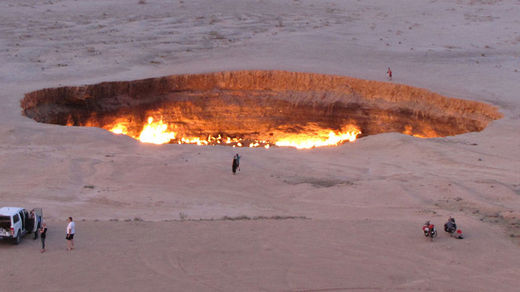
© AFP Photo/Igor SasinA picture taken on May 3, 2014, shows people visiting "The Gateway to Hell," a huge burning gas crater in the heart of Turkmenistan's Karakum desert.
An ominous gas crater that has been burning in a Turkmen desert for more than 40 years is a perfect site for boosting tourism in the country, local officials and academics say. The man-made pit, known as "the Door to Hell," earlier faced backfill.

Tourism may not be the strongest side of the Central Asian republic's economy, as only around 10,000 visitors come to Turkmenistan yearly, according to official stats - most of them from Iran, Germany and the US. However, local tourism officials say they found a promising tourist attraction - and it is really hot.

Amid the arid Karakum desert, covering most of the country and known for its extreme temperature changes, one can find a huge sinister-looking pit known as Derweze or Darvaza - commonly referred to by the locals as "the Door to Hell."

Cloud Lightning

Storm-battered South Australia braces for more wild weather

Southern Australia wild weather
© Sturt SES unit/ABC NewsA fallen tree blocks the road at Ironbank in the Adelaide Hills.

South Australia is bracing for more wild weather after thousands of properties were left without power due to strong wind and rain.

The State Emergency Service has responded to more than 170 incidents in South Australia after the state was buffeted by wind of more than 90km/h.

Trees and power lines were brought down, with the SES reporting incidents of roof tiles being ripped away and driveways being blocked by debris. The SES advised that people should stay indoors, away from windows, during high winds.

Around 6,000 premises were left without power in South Australia on Monday, with the Bureau of Meteorology warning that the extreme weather would continue for a further day.