Earth ChangesS


Arrow Down

La Nina weakening; below-average rain seen for US South

The La Nina weather anomaly blamed for the devastating floods in Australia will keep weakening in the coming months, the U.S. Climate Prediction Center predicted Thursday.

In a monthly report, the agency said a majority of weather computer models showed a return to neutral conditions by May-June 2011, while forecasts for the late summer and beyond remained highly uncertain.

CPC also said there was an enhanced chance for below-average rain across much of the Southern United States, while above-average precipitation was favored for the northern Plains.

CPC is an office of the U.S. National Oceanic Atmospheric Administration.

Cloud Lightning

Strong Wind Gusts and Heavy Rains Shower Western Cuba

Storms associated to a weak cold front caused strong winds and heavy rains in the western region of Cuba particularly in the north coast.

Gusts higher than 100 Km/H were reported in different sites, according to Jose Ramon Palacios, Shift Supervisor at the Weather Forecast Center of the Cuban Institute of Meteorology (INSMET).

Palacios told Juventud Rebelde the phenomenon was produced by a line of thunder storms associated to a weak cold front.

The storms lashed the north coast along the provinces of Pinar del Rio, Mayabeque, Artemisa and Havana, said the specialist.

Bizarro Earth

Japan: New Earthquake Brings Tsunami Warning

A powerful earthquake off the northeast coast of Japan shook a large area late Thursday. The jolt appeared to be an aftershock from the catastrophic earthquake and tsunami that hit Japan nearly four weeks ago.

The earthquake generated a tsunami warning, and Japan's NHK television immediately warned residents in the area to move to higher ground, but there were no immediate reports of major disruptions in the ocean.

The earthquake and tsunami alert raised fears about possible effects at the damaged Fukushima nuclear reactor, which has been leaking radio since the original earthquake.

The Tokyo Electric Power Company said it had no reports of any new damage or casualties near the reactor site caused by Thursday's earthquake, which hit shortly before midnight (at 1432 UTC). The aftershock was initially recorded at magnitude 7.4, but the U.S. Geological Survey later downgraded the jolt to magnitude 7.1 - still a powerful earthquake overall, but far less dangerous than the 9.0-magnitude shock on March 11.

Speaking at a news conference, a TEPCO official said water-pumping operations were continuing to keep the nuclear plant's fuel rods from overheating to a dangerous degree. Workers at the plant have been struggling to bring the nuclear reactors under control for the past three weeks.

Bizarro Earth

Australian Rats Scurry to Desert En Masse After Rains

Rats
© BBCThe rats are unlikely to stay in the desert for long.

A mass migration of rats is under way into the inland deserts of Australia after a run of high rainfall seasons, scientists say.

The native long-haired rat, or Rattus villosissimus, normally lives in the Barkly Tableland of the Northern Territory and in western Queensland.

But now it has been spotted in Alice Springs for the first time in 25 years.

"Some of them get up to about 30cm [12in] long - fair lump of a rat," livestock manager Chris Giles said.

"They will run around and hide under a little bit of shrub there, and you can get pretty close to them," Mr Giles, a stockman on the Northern Territory's Lake Nash Station, told Australia's ABC News.

"I nearly caught one the other day."

Cloud Lightning

Georgia, US: Storm fells Augusta National magnolia

magnolia trees
© Curtis ComptonAn overnight storm April 5 knocked down a 160-year-old tree at Augusta National, one of the 61 magnolias lining the drive from Washington Road to the clubhouse's circular driveway.
Students of Masters history know that 61 magnolia trees have lined the drive from Washington Road to the clubhouse's circular driveway for decades.

Early Tuesday morning, though, Augusta National's famed Magnolia Lane sprang a leak.

"I guess it has 60 magnolia trees now, instead of 61," Phil Mickelson said.

An overnight storm knocked down a 160-year-old tree whose canopy helped create an essential element of Masters tradition -- the drive from Washington to the clubhouse, which beckons in gleaming white at the end of the roughly 330-yard drive. Tuesday, a sunny patch about halfway down the lane broke up the eastern row of magnolias like a gap tooth. By 10 a.m., much of the tree, which fell away from the road, had been removed.

X

US: Thousands in Nashville still without power after 3 tornadoes hit area Monday

knocked tree
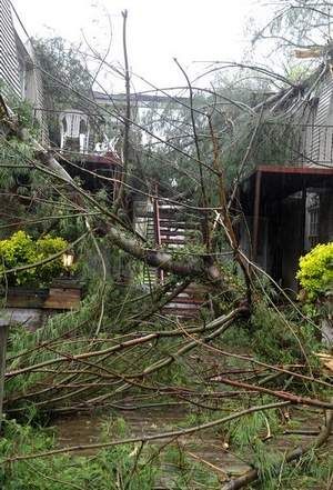
© Jeanne Reasonover/The TennesseanA tree knocked down during Monday's storms blocks the entrance to an apartment building on the 700 block of West Main Street in Franklin
Electric power was still expected to be out for thousands of Davidson County residents today as Middle Tennessee deals with wreckage from a storm system that produced three tornadoes and damaging straight-line winds.

On Monday, three EF-1 tornadoes touched down, with one striking in southern Davidson County and skipping into La Vergne, said Trevor Boucher of the National Weather Service in Nashville.

It went along the northern Williamson County and Davidson County lines, striking in La Vergne before sputtering out in Smyrna, he said.

That tornado was estimated to have winds of up to 100 miles per hour. An EF-1 category tornado can be 86 to 110 mph. The other two tornadoes hit Waverly and Dickson County.

Comment: Remember also the Nashville flood of last year:

What took US media so long to report this? Nashville Tennessee Flood 2010


Bizarro Earth

US: Oklahoma sees driest 4 months since Dust Bowl

Image
© AP Photo/Justin JuozapaviciusIn this March 14, 2011 photo, farmer Jim Freudenberger surveys his wheat crop in Coyle, Okla. Freudenberger is among thousands of farmers in the South dealing with a severe drought that has choked back crops, forcing some to plow up what won't grow months before harvest.
In most years, the dark clouds over western Oklahoma in the spring would be bringing rain. This year, they're more likely to be smoke from wildfires that have burned thousands of acres in the past month as the state and its farmers struggle with a severe drought.

Oklahoma was drier in the four months following Thanksgiving than it has been in any similar period since 1921. That's saying a lot in the state known for the 1930s Dust Bowl, when drought and high winds generated severe dust storms that stripped the land of its topsoil.

Neighboring states are in similar shape as the drought stretches from the Louisiana Gulf coast to Colorado, and conditions are getting worse, according to the U.S. Drought Monitor. The area in Texas covered by an extreme drought has tripled in the past month to 40 percent, and in Oklahoma it nearly doubled in one week to 16 percent, according to the monitor's March 29 update.

An extreme drought is declared when there's major damage to crops or pasture and widespread water shortages or restrictions.

Bad Guys

Updated: Japan - Earthquake Magnitude 7.1 - Honshu

Image
© USGS
Date-Time:
Thursday, April 07, 2011 at 14:32:41 UTC

Thursday, April 07, 2011 at 11:32:41 PM at epicenter

Time of Earthquake in other Time Zones

Location:
38.253°N, 141.640°E

Depth:
25.6 km (15.9 miles)

Region:
NEAR THE EAST COAST OF HONSHU, JAPAN

Distances:
66 km (41 miles) E of Sendai, Honshu, Japan

114 km (70 miles) E of Yamagata, Honshu, Japan

116 km (72 miles) ENE of Fukushima, Honshu, Japan

330 km (205 miles) NNE of TOKYO, Japan

Bizarro Earth

Mexico: Earthquake Magnitude 6.5 - Veracruz

Image
© USGS
Date-Time:
Thursday, April 07, 2011 at 13:11:24 UTC
Thursday, April 07, 2011 at 08:11:24 AM at epicenter
Time of Earthquake in other Time Zones

Location:
17.431°N, 93.978°W

Depth:
167.4 km (104.0 miles)

Region:
VERACRUZ, MEXICO

Distances:
91 km (56 miles) SSE of Coatzacoalcos, Veracruz, Mexico

118 km (73 miles) NW of Tuxtla Gutierrez, Chiapas, Mexico

127 km (78 miles) WSW of Villahermosa, Tabasco, Mexico

590 km (366 miles) ESE of MEXICO CITY, D.F., Mexico

Cloud Lightning

US: National Weather Service Says 2nd Mississippi River Crest Will Be Higher

flood measure
© n/a
A second crest of the Mississippi River has started in Saint Paul Minnesota.

Major floods are expected by this weekend at Prescott in far western Wisconsin. The river is already a foot-and-a-half above its flood stage at nearby Hastings Minnesota.

The National Weather Service says the Mississippi's second crest will be higher than the first one. It's the result of melting snow, plus more precipitation expected on Thursday and into the weekend.

The Mississippi is not expected to fall at Hastings until early next week. But folks down the river in La Crosse and Prairie du Chien probably won't see a major impact. Only minor flooding is forecast in both those places. The Mississippi River is about three-inches below its flood stage today in La Crosse. It's expected to rise Thursday, and then drop below its banks next Monday.