Earth ChangesS


Cloud Lightning

Philippines: La Niña to Cause Heavy Rains Until September - Pagasa

La Niña ended in the Philippines in June but would continue to make its presence felt through heavier rains up to September, the country's weather bureau announced on Wednesday.

And with this, Ondoy-like rains remain a possibility, said Science undersecretary Graciano Yumul, who supervises the Philippine Atmostpheric, Geophysical and Astronomic Services Administration. Yumul noted that there was also La Niña in the country in 2009.

"The southwest monsoon would last until September. So when a storm makes landfall and combines with the monsoon, and they bring heavy rains, it would be Ondoy-like," Yumul said.

This was what happened with Tropical Storm Ondoy, which directly hit Luzon in September 2009. Ondoy's rains, coupled with the monsoon, submerged most of Metro Manila, killing hundreds.

Yumul added that La Niña's residual effects would usually be felt three months after it left. This means that the country would experience heavier rains, whether it would come from a typhoon, a storm, a low pressure area, the tail end of a cold front or any other weather disturbance.

"What does La Niña bring? A lot of water. So now, in all that had happened - the cold front, southwest monsoon, ITCZ - there has been a lot of water," he said.

Attention

Canada: Mudslide closes Highway 1 between Chilliwack and Hope

Image
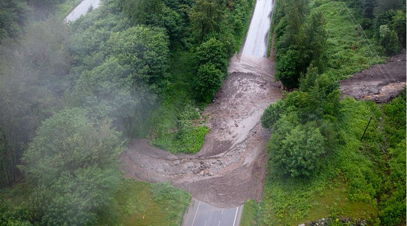
© The Canadian Press / Jonathan HaywardA mudslide covers Highway 1 east of Chilliwack, B.C. Wednesday, June 29, 2011.
A mudslide hit Highway 1 Wednesday, trapping at least one driver and leaving work crews scrambling to remove debris and eliminate the possibility of further victims.

Front-end loaders and trucks worked into Wednesday night on the stretch of highway between Chilliwack and Hope in an attempt to clear the road before the rush of vacationers descends on the highway for the long weekend.

The slide left a mess five metres deep and 60 metres wide across the eastbound lanes of the highway, about 100 metres from the Herrling Island exit.

"We weren't able to see that there was [anyone else trapped] by foot, but the equipment, as it begins to move the debris will make a determination if there's anyone else impacted," said RCMP Sgt. Peter Thiessen.

"The mudslide is large enough that it could easily cover a number of vehicles and we wouldn't know it until we uncovered them."

A woman whose vehicle was flipped over and pushed against the median escaped with minor injuries, said B.C. Attorney-General and Chilliwack-Hope MLA Barry Penner. Penner toured the site Wednesday afternoon and said cleanup crews began work at about 3:45 p.m., after geotechnical experts concluded the area was safe.

Binoculars

Australia: Enormous sinkhole swallows south-east Queensland Rainbow beach

Image

A sinkhole up to 100m long and 50m deep has opened up on a south-east Queensland beach.

The hole appeared at Inskip Point, Rainbow Beach, on Saturday night and continued to grow yesterday. It is estimated to be up to 50m deep.

Hervey Bay man Ron Morgan told the Fraser Coast Chronicle he could only watch in shock as a small hole turned into a gaping chasm 30 metres wide and kept on growing.

Bizarro Earth

UK: Mild Tsunami Strikes Cornish Coast, Shifting Water Levels 'In a Flash'


An underwater landslide is thought to have caused a small tsunami that sent holidaymakers and anglers scattering in Cornwall. Witnesses reported the sea being sucked out, or receding, before a wave struck the coast on Monday morning.

No damage was caused by the wave, thought to have been about 40cm (16in) high and causing a surge up to 90cm (3ft) by the time the seawater pushed into the Yealm estuary, 70 miles up the coast near Plymouth, Devon, but many people, along the south coast, up to Hampshire, were left baffled by the phenomenon.

There were reports that static electricity in the air at the time made people's hair stand on end.

Simon Evans, who was digging for bait on the shore at Marazion, near Penzance, described the event as akin to a horror film. He said: "It was really eerie ... the weather was really foggy but extremely warm and close, and the sea was as calm as a millpond.

"One minute I was stood at the water's edge then when I turned around the water had retreated around 50 yards.

"It was surreal, I couldn't believe what had happened. I had no idea what caused it, but I didn't really want to hang about and find out."

He said that having heard about tsunamis, he "jumped in the car and got out of there".

Bizarro Earth

Do Clues to Japan Earthquake Lie Under Costa Rican Seafloor?

Costa Rica Seafloor
© IODPThe CRISP research site is located 108 miles (174 km) off Costa Rica.

Pieces of rock and seafloor from deep in the Pacific Ocean near Costa Rica may help explain why Japan's deadly magnitude 9.0 quake was so large.

Nearly one mile of sediment cores (cylinders of earth drilled out from the ground) collected from the ocean floor off the coast of Costa Rica reveal detailed records of some two million years of tectonic activity along a nearby seismic plate boundary, where one tectonic plate dives beneath another, called a subduction zone. It was the rupture of a subduction zone that generated the Japan temblor.

The scientific drilling vessel JOIDES Resolution retrieved the samples during a recent monthlong expedition called the Costa Rica Seismogenesis Project (CRISP). Participating scientists aim to use the samples to better understand the processes that control the triggering of large earthquakes at subduction zones.

More than 80 percent of global earthquakes above magnitude 8.0 occur along subduction zones.

"It's critical to understand how subduction zone earthquakes and tsunamis originate - especially in light of recent events in Japan," said Rodey Batiza of the National Science Foundation's Division of Ocean Sciences. "The results of this expedition will also help us learn more about our own such zone off the Pacific Northwest."

Cloud Lightning

Experts warn epic weather ravaging US could worsen

extreme us weather
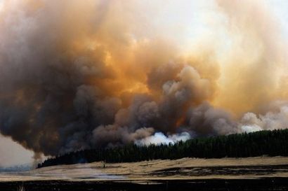
© AFP/Getty Images/Kevork DjansezianSmoke rises around the Lee Valley Recreational area in the Apache National Forest during back burn operations as the Wallow Fire continues to burn in Big Lake, Arizona on June 12. Epic floods, massive wildfires, drought and the deadliest tornado season in 60 years are ravaging the United States, with scientists warning that climate change will bring even more extreme weather.
Epic floods, massive wildfires, drought and the deadliest tornado season in 60 years are ravaging the United States, with scientists warning that climate change will bring even more extreme weather.

The human and economic toll over just the past few months has been staggering: hundreds of people have died, and thousands of homes and millions of acres have been lost at a cost estimated at more than $20 billion.

And the United States has not even entered peak hurricane season.

"This spring was one of the most extreme springs that we've seen in the last century since we've had good records," said Deke Arndt, chief of climate monitoring for the National Oceanic and Atmospheric Administration (NOAA).

While it's not possible to tie a specific weather event or pattern to climate change, Arndt said this spring's extreme weather is in line with what is forecast for the future.

"In general, but not everywhere, it is expected that the wetter places will get wetter and the drier places will tend to see more prolonged dry periods," he told AFP.

"We are seeing an increase in the amount (of rain and snow) that comes at once, and the ramifications are that it's a lot more water to deal with at a time, so you see things like flooding."

More than 6.8 million acres in the central United States have been swamped after record spring rainfall overwhelmed rivers already swollen from the melting of a heavy winter snow pack.

Some levees burst under the pressure as the mighty Mississippi River swelled to more than three miles (nearly five kilometers) in width. Others were intentionally breached in order to ease pressure and protect cities downstream.
Binoculars

Alnwick Garden's Himalayan lilies ruined by heavy rain

Image
© UnknownThe plants would usually be in flower for about three weeks
Gardeners faced a major blow after rare flowers which take seven years to bloom were ruined by storms.

The Himalayan lilies had been cared for by staff at Alnwick Garden, in Northumberland, since 2004 in anticipation of long-awaited blooms.

Head gardener Trevor Jones said heavy rains since the weekend had ripped most of the flowers from their stems.

He said they had started coming into flower at the beginning of last week and would have been a summer highlight.

Cloud Lightning

At least 31 dead as heavy rains slash India

New Delhi -- At least 31 people were killed and thousands of others homeless due to heavy rainfalls in northern and eastern India over the past few days, local media reported Wednesday.

Monsoon rain continued to lash most parts of northern India on Tuesday when 14 people were killed due to rain-related incidents in the northern Indian states of Uttar Pradesh and Uttarakhand, reported local daily The Hindu.

Meanwhile, at least 17 people died and over 900,000 people were affected in the heavy rains in the eastern Indian state of West Bengal over the past two days, said the newspaper.

Cloud Lightning

Heavy Rain Forces 16,000 to Evacuate in S.China

More than 16,000 people were forced to evacuate their homes Wednesday as torrential rains pelted parts of south Guangdong Province, local flood control authorities said.

Heavy rains unleashed by summer monsoons started to pound the Pearl River Delta and the province's west coastal region Tuesday evening, disrupting traffic and forcing people in low-lying areas to leave their homes, said a spokesman with the provincial flood control headquarters.

Over 13,500 of the evacuees were from the worst-hit city of Yangjiang, while the evacuation of the rest 2,500 was reported in the city of Taishan, where downpours flooded 20 villages, said the spokesman.

The headquarters Wednesday sent a work team to the rain-ravaged regions to direct flood-relief operations.

Cloud Lightning

Heavy Rains Batter Southeast Mexico

Cancun, Mexico - The torrential rains that fell in the last few hours in the southeastern Mexican state of Quintana Roo, brought on by a tropical wave, abruptly halted outdoor tourist activities, caused ports to be closed to small boats and flooded much of the state.

Municipal authorities on Monday launched Operation Storm to activate contingency plans for flooded areas and safeguard those living in vulnerable districts.

Maritime authorities stopped the sailing of small boats throughout the Mexican Caribbean as a preventive measure and hoisted red flags to warn bathers of the risk of powerful waves.

The heavy rains and high winds brought on by the tropical wave began Saturday afternoon.