Secret History
The finds, located roughly 270 miles south of Cairo, come from a period of over 1,000 years, from the Sixth Dynasty to the Heroic Age, making some of the discoveries over 4,300 years old.
In addition to the ancient ram's head, archaeologists from the University of New York also discovered a group of mummified dogs, wild goats, cows, deer and an ostrich.
The mummified remains are believed to have been left at the site to honor Ramses II about 1,000 years after his death, the Egyptian Ministry for Tourism and Antiquities said.
It is thought that the rams and other animals would have been used as offerings during worship of the rams in Abydus during the Bipidus period, Dr Sameh Iskandar, head of the mission added in a statement.

View of the chevet of Notre-Dame de Paris under restoration.
At the time of its construction in the mid-12th century, Notre-Dame was the tallest building ever erected, reaching a height of 32 meters.
Previous research suggests that this record was made possible by combining a number of architectural innovations. However, despite extensive use of iron reinforcements in more recent cathedrals and in efforts to restore old buildings, it has been unclear what role iron might have played in Notre-Dame's initial construction.
The team that discovered the art inside Cova de la Vila described it as "exceptional, both for its singularity and excellent state of conservation."
In the Cova de la Vila cave in La Febró (Tarragona), in northeastern Spain's region of Catalonia, more than 100 prehistoric engravings have been found, arranged on an eight-meter panel.
According to experts, it is a composition related to the worldview of agricultural societies and farmers of the territory. One of the singularities of this mural is that it is made exclusively with the engraving technique, with stone or wood tools.
The engravings include shapes that resemble horses, cows, suns, and stars.
Julio Serrano, Montserrat Roca, and Francesc Rubinat were the cavers responsible for the discovery; they collaborated with Josep Vallverd, Antonio Rodrguez-Hidalgo, and Diego Lombao, researchers from the Catalan Institute of Human Paleoecology and Social Evolution (IPHES-CERCA), and Ramón Vias, an expert in prehistoric rock art.
It was in May 2021, during some scans and topographical work by a group of speleologists in the Barranc de la Cova del Corral, that they discovered the Cova de la Vila, a cavity excavated by Salvador Vilaseca in the 1940s and whose coordinates appear to have been lost.
"Representations of the zodiac are very rare in Egyptian temples," Leitz says, adding "The zodiac itself is part of Babylonian astronomy and does not appear in Egypt until Ptolemaic times." Researchers think the system of zodiac signs and their related constellations was introduced to Egypt by the Greeks and subsequently became popular. "The zodiac was used to decorate private tombs and sarcophagi and was of great importance in astrological texts, such as horoscopes found inscribed on pottery sherds," says Dr. Daniel von Recklinghausen, a Tübingen researcher. "However, it is rare in temple decoration: Apart from Esna, there are only two completely preserved versions left, both from Dendera," he says.

A close-up of the mummified bear's head. The bear, unearthed in 2020, was originally assumed to be an extinct cave bear that dated back at least 22,000 years. But a new necropsy reveals it is actually a brown bear that lived 3,500 years ago.
Reindeer herders unearthed the remains, which include the bear's intact skin, fur, teeth, nose, claws, body fat and internal organs, on Bolshoy Lyakhovsky Island, a remote Russian island located in the East Siberian Sea. Researchers named it the Etherican bear, after the nearby Bolshoy Etherican River.
Comment: Ice bridge? Land bridge? Either way, it may reveal how significantly different the geography of certain regions has been at different times in the past.
- The Seven Destructive Earth Passes of Comet Venus
- Ancient Doggerland archipelago survived Storegga tsunami 8,000-years-ago
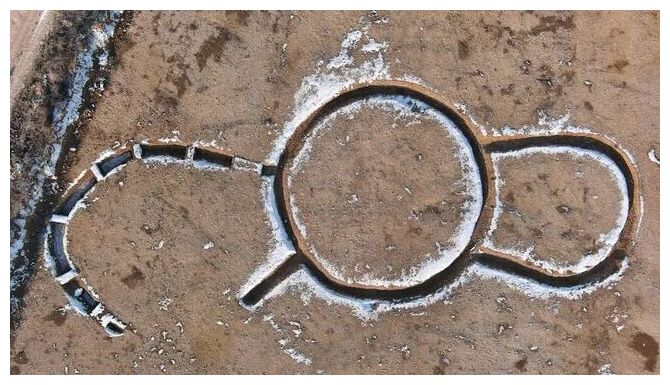
Cropmarks on aerial photographs hinted at the presence of several ring ditches and linear ditches on and close to the site. Our team confirmed the existence of these features through trial trench evaluation. We then conducted a strip, map and sample excavation to fully reveal and investigate the remains, leading to the discovery of a complete ring ditch and a substantial linear ditch.
The ring ditch during excavation, with a possible entrance visible in the foreground. There was at least one re-cutting of the ring ditch, suggesting maintenance and possible longevity of use.

Interlocking stone cells found outside of the base of mustatil IDIHA-F-0011081.
According to an in-depth new analysis, the mysterious, rectangular enclosures were used by Neolithic people for unknown rituals, depositing animal offerings, perhaps as votives to an unknown deity or deities. Excavations have revealed hundreds of fragments of animal remains, clustered around an upright slab of stone interpreted as sacred.
The roughly 7,000-year-old monuments known as mustatils (an Arabic word meaning rectangles) have baffled archaeologists since attracting scientific attention in the 1970s.
It wasn't until 2017, however, that the full extent of their spread across the Arabian Peninsula was revealed in the first scientific paper documenting their discovery. Aerial surveys have aided in the identification of over 1,600 mustatils, sometimes in groups, scattered throughout the desert.
Nicknamed 'gates' because of their appearance from the air, mustatils were described in that paper as "two short, thick lines of heaped stones, roughly parallel, linked by two or more much longer and thinner walls."
They consist of two short, thick platforms, linked by low walls of much greater length, measuring up to 600 meters (2,000 feet), but never more than half a meter (1.64 feet) high.
Many archaeologists believed that the earliest swords only dated to around 1600 or 1500 BCE before the discovery of a cache of swords at the archaeological site of Arslantepe in Turkey.
The nine swords from the archaeological site of Arslantepe (Melid) attest to the use of this weapon for the first time in the world - at least a millennium before the already-known examples. They date back to the Early Bronze Age (c. 33rd to 31st centuries).
In the 1980s, Marcella Frangipane's team at Rome University discovered a cache of nine swords and daggers dating all the way back to 3300 BCE. Frangipane declared the swords of Arslantepe the world's oldest and first swords ever discovered.
They are made of an alloy of arsenic and copper. Three of the swords were exquisitely inlaid with silver. These weapons have a total length of 45 to 60 cm, which points to either a short sword or a long dagger classification.
Archaeologists have been researching an area under the North Sea, known as Doggerland, which was home to one of the largest prehistoric settlements in Europe.
But with expansion of wind farms in the North Sea, the race is on to work with developers to piece together information about Doggerland in advance of development.
PhD student Ben Urmston will look for anomalies in magnetic fields by analysing magnetometry data, which could indicate the presence of archaeological features without excavation.
He said: "Small changes in the magnetic field can indicate changes in the landscape, such as peat-forming areas and sediments, or where erosion has occurred, for example in river channels.
"As the area we are studying used to be above sea level, there's a small chance this analysis could even reveal evidence for hunter-gatherer activity. That would be the pinnacle.
"We might also discover the presence of middens, which are rubbish dumps that consist of animal bone, mollusc shells and other biological material, that can tell us a lot about how people lived."

What started as a team-building exercise to train a group of PhD hydrogeophysics researchers to use specialist equipment, ended up providing evidence of an extensive religious enclosure lying just outside the Roman military fort at Lancaster.
Professor Andy Binley, an expert in hydrogeophysics at Lancaster Environment Centre, offered to use his research expertise and equipment to continue the work of the Beyond The Castle archaeological project, when heritage lottery funding ran out in 2017.
"I had a few PhD students doing geophysical research and thought this was an interesting group hobby project, training them on techniques and getting them to work as a team," said Professor Binley, who uses geophysical methods to solve hydrological problems, such as assessing underground water in agriculture and tracking groundwater contamination.
Lancaster had a large military fort and garrison in Roman times. It was an important command centre between Chester and Hadrian's Wall and a base for naval operations and supply. The Beyond the Castle project had been using standard geophysical techniques followed by trial excavation to explore the green open space between Lancaster Castle and the River Lune. These had revealed evidence of a building, thought to be a Roman warehouse, under an area called Quay Meadow, owned by Lancaster City Council. But Professor Binley and his students would make much more extensive, and exciting discoveries.
"What Andy brought to the project was much more sophisticated techniques and up to date equipment and someone from outside archaeology to apply a critical eye," said the Beyond the Castle project's leading archaeologist, Jason Wood. "The Roman archaeology in this area of Lancaster is very shallow because it hasn't been built on. Consequently the archaeological layers are much nearer the surface, so there is wonderful potential."
Comment: See also: