Secret HistoryS


Hourglass

Ireland's storms unearths 6,000 year old dwellings near Galway

omey island
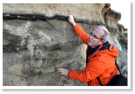
© Joe O'Shaughnessy / Irish TimesArchaeologist Michael Gibbons investigates the area on Omey Island where 6,000-year-old dwellings were revealed by storm damage.
The recent storms that battered Ireland's countryside and coastlines unearthed a hidden gem amidst the devastation to properties and landscape.

The storms have exposed evidence of life dating back to the Neolithic period on Connemara's Omey island. Large linear archaeological deposits of up to a meter thick have been exposed on the western and northern shorelines of the tidal island off Claddaghduff.

The Irish Times reports two sets of medieval burial sites, traces of sunken dwellings and parts of a Neolithic bog which had been covered over for millennia by shifting sands, have been revealed.

Info

London skulls reveal gruesome evidence of Roman head hunters

Skull
© The Guardian, UKThe work of Redfern and Bonney may force archaeologists to have another look at more recent skull finds such as the one above, excavated during work on a new Crossrail station.
Scores of skulls excavated in the heart of London have provided the first gruesome evidence of Roman head hunters operating in Britain, gathering up the heads of executed enemies or fallen gladiators from the nearby amphitheatre, and exposing them for years in open pits.

"It is not a pretty picture," Rebecca Redfern, from the centre for human bioarchaeology at the museum of London, said. "At least one of the skulls shows evidence of being chewed at by dogs, so it was still fleshed when it was lying in the open."

"They come from a peculiar area by the Walbrook stream, which was a site for burials and a centre of ritual activity - but also very much in use for more mundane pursuits. We have evidence of lots of shoe making, so you have to think of the cobbler working yards from these open pits, with the dog chewing away - really not nice."

"We believe that some of the heads may be people who were killed in the amphitheatre. Decapitation was a way of finishing off gladiators, but not everyone who died in the Roman amphitheatre was a gladiator, it was where common criminals were executed, or sometimes for entertainment you'd give two of them swords and have them kill one another. Other heads may have been brought back by soldiers from skirmishes, probably on the Hadrian or Antonine walls - again, it would have taken weeks to bring them back, so not a nice process."

The 39 skulls were excavated at London Wall almost within sight of the Museum of London in 1988, and deposited at the museum, but the scientists have only recently applied improved forensic techniques to them. Redfern and her colleague Heather Bonney, from the Earth Sciences Department of the Natural History Museum, publish their results for the first time this week in the Journal of Archaeological Science.
Info

Ancient map could warn of active volcano

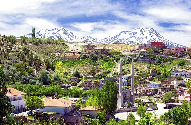
Mt. Hasan
© Grand Tour/CorbisA village sits at the foot of the volcanic peaks of Mount Hasan.
Approximately 9,000 years ago in Anatolia, Turkey, an artist drew what could be the world's oldest known map, complete with a volcano erupting in the background. A recent discovery of lava rock from that time serves as evidence that the painting may indeed be an early example of both cartography and vulcanology.

Some archeologists interpreted the painting as a Google Earth-style layout of Çatalhöyük, a Stone Age settlement in modern-day Turkey, with Mount Hasan (Hasan Daği in Turkish) in the background. In the 3 meter-long wall painting, the twin-peaked mountain seems to be erupting. But no evidence for an eruption of Mount Hasan had been found from the right time period.

However, geologists recently found a layer of volcanic pumice on the summit of Mount Hasan that may have come from the eruption depicted in the painting. The chemical signature of the pumice suggested the volcano erupted in 6960 BC (± 640 years), the same time when thousands of humans lived in Çatalhöyük. PLOS ONE published the results of the analysis led by Earth scientists at UCLA.

Pyramid

Underwater pyramid found near Portugal has Portuguese Navy investigating, link to Atlantis?

Image
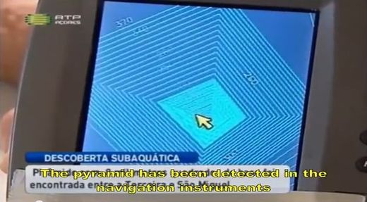
"Researchers have discovered an underwater pyramid 60 meters high and 8000 meters square base between the islands of Terceira and São Miguel. The structure was identified by the sailor Diocleciano Smith based on bathymetry readings. The author does not believe that the pyramid is of natural origin."
Portuguese news reported the discovery of a very large under water pyramid first discovered by Diocleciano Silva between the islands of São Miguel and Terceira in the Azores of Portugal. According to claims, the structure is said to be perfectly squared and oriented by the cardinal points. Current estimates obtained using GPS digital technology put the height at 60 meters with a base of 8000 square meters. The Portuguese Hydrographic Institute of the Navy currently has the job of analyzing the data to determine whether or not the structure is man-made.
"The pyramid is perfectly shaped and apparently oriented by the cardinal points," Silva told Diário Insular, the local newspaper.
The pyramid was found in an area of the mid-Atlantic that has been underwater for about 20,000 years. Considering this is around the time of the last ice age where glaciation was melting from its peak 2000 years prior, whatever civilization, human or not, that was around before the ice age, could be responsible for building the pyramid. While the Portuguese Navy still hasn't determined the origins, many might question why this hasn't been first reported on sooner than late 2012. Certainly the NOAA who studies volcanic activity in the area of the pyramid would have discovered the pyramid through sonar imaging and so forth since the area is heavily studied due to volcanic activity. Either the NOAA hasn't yet come across it, they are hiding what they have found, or the pyramid doesn't exist. The last theory does not seem to be likely given the authenticity of the find.


Star of David

Solzhenitsyn - Banned all over again

Image
Solzhenitsyn's last and greatest book - freely available in Russia - is facing the same censorship in the West that The Gulag Archipelago faced in the Soviet Union. That's because it deals with the Jews - specifically, their role in the Bolshevik Revolution.
In his Nobel Prize acceptance speech, Alexander Solzhenitsyn wrote that he had been "convinced I should never see a single line of mine in print in my lifetime".

The Gulag Archipelago
, which sold 30 million copies in 35 languages, never was published in the Soviet Union. Despite KGB attempts to confiscate it, the manuscript was smuggled out and published in the West. Now, it is mandatory reading in Russian schools.

Alexander Solzhenitsyn's last book is facing the same censorship in the West that The Gulag Archipelago faced in the Soviet Union. That's because it deals with the Jewish role in the Bolshevik Revolution.

Solzhenitsyn's book Two Hundred Years Together: Russo-Jewish History was published in Russian in 2001/2. Since then, German and French editions have been published, but no English-language edition.

The wikipedia webpage on Alexander Solzhenitsyn includes this statement:
"Solzhenitsyn also published a two-volume work on the history of Russian-Jewish relations (Two Hundred Years Together 2001, 2002). Never published in the USA, this book stirred controversy and caused Solzhenitsyn to be accused of anti-Semitism."

Blue Planet

Gunung Padang: The lost records of Atlantis?

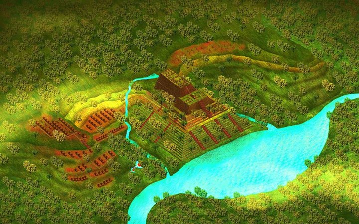
Gunung Padang
© Pon S PurajatnikaArtist's impression of Gunung Padang as it would have looked in antiquity
"Everything we've been taught about the origins of civilization may be wrong," says Danny Natawidjaja, PhD, senior geologist with the Research Centre for Geotechnology at the Indonesian Institute of Sciences. "Old stories about Atlantis and other a great lost civilizations of prehistory, long dismissed as myths by archaeologists, look set to be proved true."

I'm climbing with Dr Natawidjaja up the steep slope of a 300-ft high step-pyramid set amidst a magical landscape of volcanoes, mountains and jungles interspersed with paddy fields and tea plantations a hundred miles from the city of Bandung in West Java, Indonesia.

The pyramid has been known to archaeology since 1914 when megalithic structures formed from blocks of columnar basalt were found scattered amongst the dense trees and undergrowth that then covered its summit. Local people held the site to be sacred and called it Gunung Padang, the name it still goes by today, which means "Mountain of Light", or "Mountain of Enlightenment", in the local Sundanese language. The summit, where the megaliths were found arranged across five terraces had been used as a place of meditation and retreat since time immemorial, archaeologists were told, and again this remains true today.

Black Magic

Charms to ward off demons found under ancient floors

Ancient Artifacts
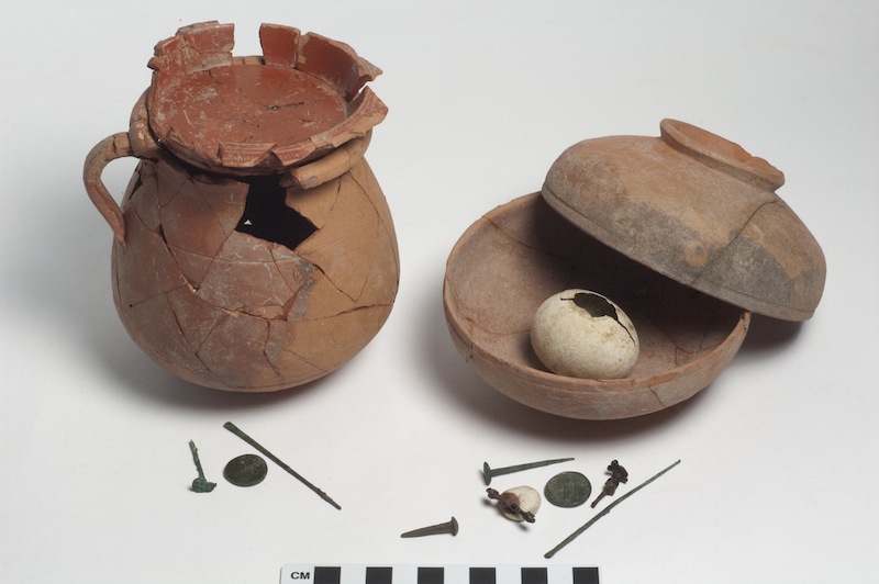
© Archaeological Exploration of Sardis/Harvard UniversityThese deposits were buried under an ancient floor in Sardis nearly 2,000 years ago. Archaeologists who found them in 2013 suspect the artifacts may have been part of a ritual to ward off disaster.
Residents of Sardis, an ancient city in modern-day Turkey, spent decades rebuilding after a devastating earthquake struck one night in the year A.D. 17. To ward off demons and future disasters, some locals may have sealed eggshells under their new floors as lucky charms, archaeologists found.

In the summer of 2013 archaeologists were excavating an ancient building at Sardis that was constructed after the earthquake. Underneath the floor, they found two curious containers that each held small bronze tools, an eggshell and a coin, resting just atop the remains of an earlier elite building that was destroyed during the disaster.

The objects in the odd assemblages were important in ancient rituals to keep evil forces at bay, and the archaeologists who found them believe they could be rare examples of how the earthquake affected ancient people on a personal level. [See Images of the Ritual Offerings at Sardis]

Question

Shocking evidence Hitler escaped Germany

Newly declassified FBI, U.S. intel files raise startling questions.

Hitler Escaped_3
© WND.com
Washington - Everyone knows Adolf Hitler committed suicide by gunshot in his underground bunker on April 30, 1945.

At least, that has been the conventional wisdom.

Now comes WND senior staff reporter Jerome R. Corsi's new book, Hunting Hitler: New Scientific Evidence That Hitler Escaped Germany."

Examining declassified FBI and U.S. military intelligence files, Corsi makes a compelling case that U.S. investigators suspected from the beginning Hitler had escaped. For political purposes, the evidence indicates, they were willing to go along with the cover story that in the final days of World War II, Hitler married his mistress, Eva Braun, and the two took their lives in a joint-suicide ritual just before the Soviet army entered Berlin.

But the truth is, no one actually saw Hitler commit suicide. There are no photographs documenting a joint suicide of Hitler and Eva Braun, and the bodies of the two were never recovered or preserved for positive identification.

Info

Lasers unearth Lost 'Agropolis' of New England

Aerial Images
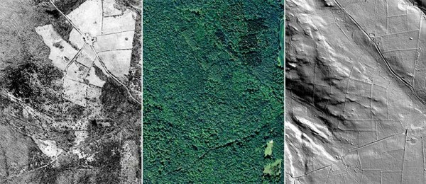
© (left to right) UConn MAGIC and CT State Library; CTECO; USDA/NRCSHiding in plain sight. Aerial images of Plainfield, Connecticut, show a farmed region in 1936 (left) and 2012 (middle). LiDAR digital elevation maps (right) unveil the roads, stone walls, and buildings of a former “agropolis,” hiding beneath the canopy.
Hidden ruins are customary in the wild jungles of South America or on the white shores of the Mediterranean Sea. Now, researchers have uncovered a long-lost culture closer to Western civilization - in New England.

Today, southern New England is shrouded by lush forests, whose autumnal colors attract thousands of tourists and hikers each year. Urban hubs - Boston, Providence, Hartford - are peppered throughout. Rewind the clock 300 years, however, and the landscape would be unrecognizable, with much of the wooded countryside replaced by hundred-acre farms. Agriculture was king in New England until widespread industrialization in the 19th century led farmers to abandon their fields and move to cities. The forest stirred and soon reclaimed the disavowed land, cloaking the structural relics of a vast agrarian past.

In a new study, which will be published in the March issue of the Journal of Archaeological Science, geographers Katharine Johnson and William Ouimet of the University of Connecticut, Storrs, uncovered these preserved sites without ever lifting a shovel. Using aerial surveys created by LiDAR, a laser-guided mapping technique, the team detected the barely perceptible remnants of a former "agropolis" around three rural New England towns.

Cardboard Box

Flashback French government queries U.S. State Dept. about fatal 1951 LSD attack on village in south of France

Image
Prompted by a new book release, the State Department's Bureau of Intelligence and Research has received a confidential inquiry from the office of Erard Corbin de Mangoux, head of the French intelligence agency, Directorate General for External Security (DGSE), concerning a recent account of American government complicity in a mysterious 1951 incident of mass insanity in France. The DGSE is the French counterpart of the CIA.

The incident took place in the village of Pont-Saint-Esprit in southern France, and is described in a recent book about the 1953 death of an American biochemist, A Terrible Mistake: The Murder of Frank Olson and the CIA's Secret Cold War Experiments. The book, by investigative journalist H.P. Albarelli Jr., was published in late November 2009 by TrineDay, which specializes in books about "suppressed information."

The strange outbreak severely affected nearly five hundred people, causing the deaths of at least five. For nearly 60 years the Pont-St.-Esprit incident has been attributed either to ergot poisoning, meaning that villagers consumed bread infected with a psychedelic mold, or to organic mercury poisoning. But Albarelli reports that the outbreak resulted from a covert LSD aerosol experiment directed by the US Army's top-secret Special Operations Division at Fort Detrick, Maryland. He notes that the scientists who produced both alternative explanations worked for the Sandoz Pharmaceutical Company, which was then secretly supplying both the Army and CIA with LSD.

Comment: See here for more on the author's comments regarding the shady deal between the French government and U.S. Army scientists.