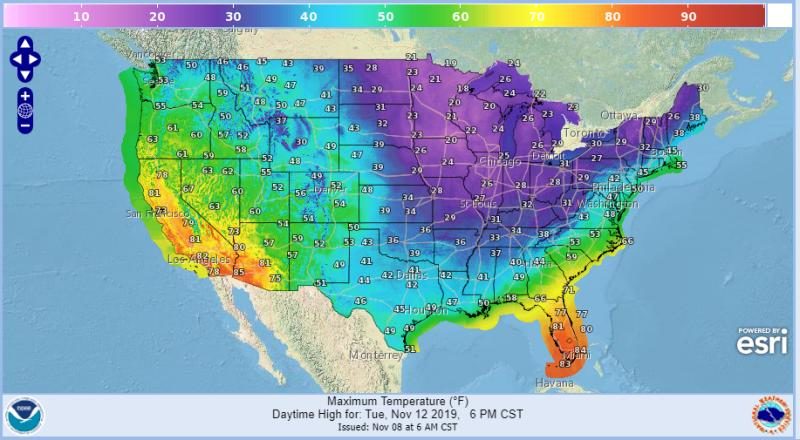
© National Weather Service
I rarely curse, but
kiss my jim-jams these next few weeks look truly brutal North America!
Unrelenting too, as wave after wave of destructive Arctic conditions could stretch key services to breaking point.According to latest GFS runs, temperature departures of
20C below the seasonal average will infect
ALL of the central & eastern United States for long spells over the next two weeks, with only a pocket to the far-west spared.
The Arctic cold looks set to
really take grip during the early part of next week
(Nov 11 & 12).
The fronts will also deliver heavy, potentially record-breaking early-season snow to many.
The
Northeast looks set to bore the brunt, with up to
30 cm (11.8 inches) accumulating here — but there are even some super-rare flurries showing-up in
southern Georgia into
Alabama, too.
And
Canada won't be missing out, not by any means.
Bone-chilling lows and widespread snows are
also forecast north of the border.
This all serves as yet more evidence of the lower-latitudes COOLING, and cooling fast.
Yes, a few far-northern areas like
Alaska and the
Arctic are warming -
slightly- but 1) no one lives up there so quite frankly, who cares, and 2) as NASA succinctly identify in their 'Maunder Minimum Temperature Reconstruction Map
(below),
these regions are expected to warm during periods of global cooling, as are the North Atlantic, Iceland and the southern tip of Greenland.
And regarding any Arctic sea ice melt -
and the potential consequences for sea level rise- again, a non-issue. At least 90% of the planet's ice is safely locked up in Antarctica which, for as long as we can tell, has been steadily advancing, comfortably offsetting the comparatively
tiny losses observed at its northern cousin.
Scientists have long-understood that studying
the jet stream is key to understanding weather and climate, but to properly study the jet stream attention must turn to the sun — something not so widely perceived.
Low solar activity disrupts that band of meandering air flowing some 6 miles above our heads, reverting its usual tight
Zonal flow to a weak
Meridional one. This
wavy flow diverts cold Arctic air to the lower-latitudes -
where us humans reside- and shifts warm Tropical air north.
Note the hysteria regarding the anomalous warmth over Greenland this summer.
Well, Greenland's cold temperatures didn't up and vanish, they didn't escape Earth's atmosphere and leak into space — they were simply diverted south by a
wavy jet stream.
It is THIS mechanism which fully explains the far-northern-latitudes experiencing pockets of anomalous heat of late, and conversely the lower-latitudes suffering record-breaking cold.
We've known the basics for decades -
as the below article from 1975's Science Mag would indicate-
but as they clash with the modern AGW consensus, they've conveniently been forgotten.Don't be fooled by bogus political ideologies — the lower-latitudes are refreezing in line with
historically low solar activity. NASA has revealed this upcoming solar cycle
(25) will be "
the weakest of the past 200 years," and they've correlated previous solar shutdowns to prolonged periods of global cooling
here.
www.geoengineeringwatch.org