The southwest of the Canadian province appears to have fared the worst this week.
According to data from Environment Canada, the mercury in Banff plunged to -23.3C (-9.9F) on Monday morning, which set a new daily low for October 29, eclipsing the previous mark of -22.6C (-8.7F) set back in 1991.
The Bow Valley area saw temperatures sink to -23.2C (-9.8F), low enough to pip the previous all-time record for the date — the -23C (-9.4F) from 2002.
While things got even colder at Hendrickson Creek, located northwest of Edmonton; a teeth-chattering low of -29.2C (-20.6F) was observed here, which comfortably surpassed the -26.2C (-15.2C) set back in 1996.
#abstorm It sure was a cold start to the day in western portions of the province this morning! 🥶 Check out some of these record low temperatures from earlier today, October 29: pic.twitter.com/GrotZnMdIh
— ECCC Weather Alberta (@ECCCWeatherAB) October 29, 2019
Latest GFS runs suggest there's a good chance of some Halloween snow on Thursday, though that the largest accumulations will likely mount in the morning, well before any trick-or-treating gets underway.
It will still be a cold one though, with temperature departures tumbling as much as 20C below normal for the season.
The cold times are returning.
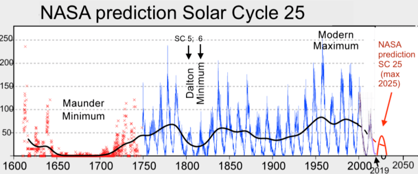
Arctic air is being diverted unusually-far south on the back of a meridional (wavy) jet stream flow, which in turn is brought on by historically low solar activity.
NASA has recently revealed this next solar cycle (25) will be "the weakest of the past 200 years," and they've correlated previous solar shutdowns to prolonged periods of global cooling here.
Prepare for the COLD.


Reader Comments