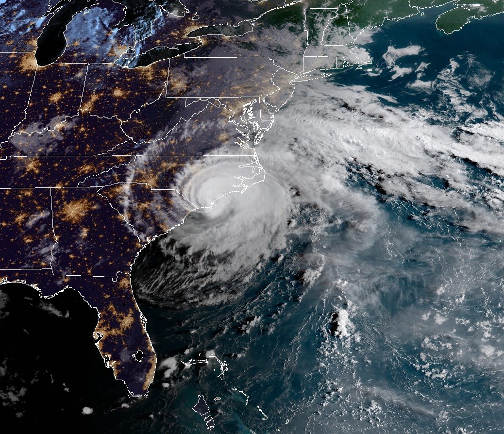
© NOAA/GOES-EastHurricane "Florence" at 11:45 UTC on September 14, 2018.
Hurricane Florence is ravaging the US East Coast, knocking out power to half a million homes, causing buildings to crumble and stranding residents.
The centre of the storm made landfall at Wrightsville Beach, North Carolina, with gales of up to 90mph (150 km/h).
Rains and surging seas have already inundated coastal areas. Dozens of people were rescued from a collapsing hotel in North Carolina.
Evacuation warnings are in place for 1.7 million people.North Carolina Governor Roy Cooper told a news conference that whole communities "could be wiped away".
"This is an uninvited brute that just won't leave," he told NBC.
The state's transportation secretary, James Trogdon, said the state may see
"flood events" that normally only occur once every 1,000 years.National Weather Service forecaster Brandon Locklear said North Carolina is likely to see eight months of rain in two to three days.
Thousands of miles away, meanwhile,
a huge typhoon is moving towards the Philippines.
More than five million people are in the path of Super Typhoon Mangkhut, officials say.Conditions deteriorated on Friday as slow-moving Hurricane Florence crawled along at 3mph (4.8km/ h).
The National Hurricane Center says the tempest remains extremely dangerous because of the high volume of rainfall and predicted storm surges, even though its wind speeds lowered slightly on Thursday night, making it a category one hurricane.By Friday morning, the North Carolina coastal town of Atlantic Beach had already received 30in (76cm) of rain, the US Geological Service said.

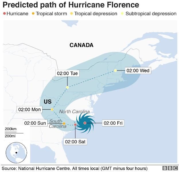
© NHC/BBC
The storm is forecast to dump about 18 trillion gallons of rainwater on US soil, most of it in North Carolina, meteorologist Ryan Maue
tweeted.
Hurricane Harvey last year dumped some 33 trillion gallons of rainwater in the US.
More than 505,000 homes and businesses are already without power, and energy companies warn up to three million homes and businesses could lose electricity.Officials have warned restoring electricity could take days or even weeks.
In Jacksonville, North Carolina, officials rescued about 60 people overnight from a hotel that was collapsing in the storm.
Emergency workers arrived to find the Triangle Motor Inn's structure crumbling, with many guests still in their rooms.
As parts of the roof caved in, police had to force their way into some suites amid 75mph winds to reach those inside.
All of the occupants, who included children and pets, were safely rescued.
Parts of New Bern, North Carolina, which is home to 30,000 people, are 10ft (3m) underwater.
Several hundred people have been plucked to safety by authorities in the riverfront city.
Local resident Peggy Perry told CNN she was "stuck in the attic" along with three relatives.
"In a matter of seconds, my house was flooded up to the waist, and now it is to the chest," she added.
Officials have warned against entering attics, unless people have a means to cut through to the roof to avoid drowning.
More than 20,000 people are meanwhile taking refuge in emergency shelters.
At the White House, President Donald Trump has been retweeting local emergency officials' updates and tips for surviving the storm.
How long will this last?Latest predictions show the storm slowing to a near standstill as it pummels the coast with "copious amounts of rain" from Thursday night to Saturday.Wind speeds are only expected to weaken on Saturday as the storm moves slowly across land.
More than a dozen counties in North Carolina are under a tornado watch, with officials also warning of a chance of hail.
Is global warming to blame?The relationship between climate change and hurricanes is a complex one.
Warmer seas power hurricanes. So as the temperature of ocean water goes up, we might expect the intensity of hurricanes to increase in future.
A hotter atmosphere can also hold more water, so this should allow hurricanes to dump more water on affected areas.
But there are so many factors that contribute to these rare events, it has been difficult to tease out clear trends from the data.
Comment: Unseen in 35 years: Veteran weather reporter on oceans 'exploding with cyclonic activity'
UPDATE: BBC on 15th Sept. reports: