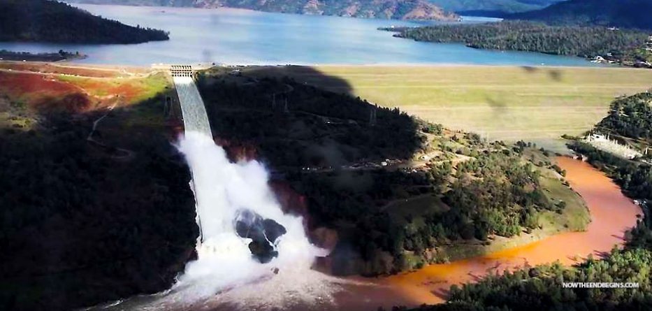
Oroville Dam
Potent storms will return to the western United States at midweek, bringing a renewed threat for travel disruptions and flooding.
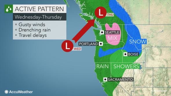
The weather pattern that has promoted dry weather along the West Coast since the weekend will break down on Wednesday. This will allow the river of moisture to resume from Washington to California.
"After a few dry days across the West Coast, stormy weather will return, first across the Pacific Northwest and later across all of Caliifornia," AccuWeather Meteorologist Brett Rathbun said.
Pacific Northwest, Northern California to face drenching rain, ice and snowLocally heavy rain will push inland along the Interstate-5 corridor from Seattle to Portland, Oregon, throughout Wednesday. During Wednesday night, soaking rain will sink southward into San Francisco and Sacramento, California.
Excessive runoff due to the saturated nature of the soil can cause flash flooding as well as mudslides. Rivers can rise above flood stage and overflow their banks.Motorists will face hazards such as excess water on roadways and reduced visibility.
"While most of the valley areas will have mainly rain, areas of freezing rain and sleet will affect parts of central Washington, including Snoqualmie Pass," Rathbun said.
Travel along portions of interstates 82, 84 and 90, could be slippery and dangerous.
As winds turn gusty with the storm, trees can fall and power line damage can occur.
As colder air rushes in from Wednesday night into Thursday, snow levels will lower across the Cascades and northern Sierra.
Unlike past storms this winter, Seattle and Portland will not be in the threat zone for snow and ice.
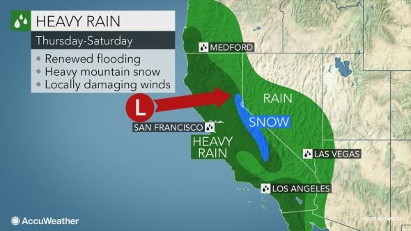
Southern California to face significant impacts late weekThe second storm from Friday to Saturday will track much farther south compared to the midweek storm.
"
The storm from Friday to Saturday has the potential to be the biggest of the winter in terms of rainfall and impact to much of Southern California," according to AccuWeather Meteorologist Jim Andrews.
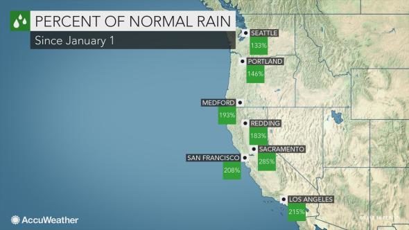
Most areas from the Los Angeles basin to San Diego can expect 3 to 6 inches of rain to fall. Even higher rainfall amounts are forecast along the west- and south-facing slopes of the Transverse ranges and Sierra Nevada. Rainfall in this region can range from 6 to 12 inches from the single storm at the end of the week.The significant rain and snow so far this winter has eliminated the worst of the drought across California. However,
the rain will struggle to soak into the saturated ground, raising the threat for flooding, mudslides and rock slides.Feet of snow will pile up across the Sierra, adding to the above average snow pack already in place. Travel may once again be impeded over Donner Pass.
"On average, February is the wettest month of the year across Southern California," according to AccuWeather Meteorologist Brett Rathbun.
The resurgence of wet weather could pose a new round of problems for crews scrambling to repair a damaged emergency spillway at the dam at Lake Oroville north of Sacramento, California.A complex operation has begun to temporarily repair a hole in the spillway before the new round of storms arrive.
Any rain this week will increase the flow of water into the lake and threaten to hinder efforts to manage the crisis.

Reader Comments
to our Newsletter