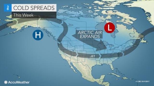
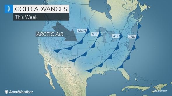
A wave of arctic air will spread from the Pacific coast to the Atlantic coast of the United States during the first week of 2017.
The cold air will continue to
invade the northwestern U.S. early this week. The cold air was accompanied by accumulating snow to near sea level in Washington on New Year's Day.
Over the Southwest, including Southern California and southern Arizona, the chilliest days will be the first part of the week as temperatures will moderate late in the week. Cold air will hang on much of the week in the Northwest.
"The main thrust of the cold air will extend from the northern Rockies to the northern Plains and the Upper Midwest," according to AccuWeather Meteorologist Evan Duffey. In this swath,
a snowstorm will precede the arrival of the arctic air.
By the middle of the week, actual temperatures will bottom as low as 20 degrees Fahrenheit below-zero and will rival the coldest air of the season so far over the northern tier of the Central states. AccuWeather RealFeel Temperatures over part of the northern Plains and Rockies can dip as low as minus 40 for a time.
Cold air will sweep to the Atlantic coast and will penetrate into part of the Deep South.
The cold blast will follow an early-week surge of mild air with
rain and even severe thunderstorms in some locations.
People in the Chicago area will endure at least a couple of days with highs in the teens and low temperatures in the single digits at the end of the week.
Temperatures at these levels are 15 to 20 degrees below average even for January."Even though the cold air will moderate by the time it gets to the Southern and Eastern states, it will still pack a punch," Duffey said.
For example, in Pittsburgh, following temperatures surging into the 50s on Tuesday, temperatures will fall through the 30s and 20s on Wednesday to the teens by Thursday morning. Factoring in wind and other conditions, RealFeel temperatures will plunge to near zero at times on Thursday. It will feel nearly 60 degrees lower on Thursday morning, when compared to Tuesday evening.
Around New York City, high temperatures may struggle to get much past the freezing mark this weekend.
In the Atlanta area, high temperatures in the upper 60s on Tuesday will be replaced with highs in the 40s and lows in the upper 20s by the end of the week.
Even in Houston and New Orleans, temperatures will be slashed by 20 degrees from their early-week highs.
Over the Florida Peninsula, temperatures will be trimmed back to near normal by the end of the week. In Orlando, this will translate to highs near 70 and lows at night in the upper 40s to lower 50s.
"Even though it will get cold over the interior South, we do not expect a freeze in the active growing areas of Southern California, Texas, Florida and Louisiana with this air mass," Duffey said.
Temperatures will moderate from west to east during the second week of January.


Alex, you're an alarmist. Those temperatures reflect (moderate) winter conditions. If this were October, I'd say, "Alex, you've got a scoop!" You should have been here two years ago....By the way, where were you then? Martinique? Cancun? Sri Lanka?
It's 4 Celsius (39F) at 5 pm here in Ontario. Tomorrow will be 6 Celsius (43F), going down to -7 Celsius (20F) later in the week.
Uhm, fake news?