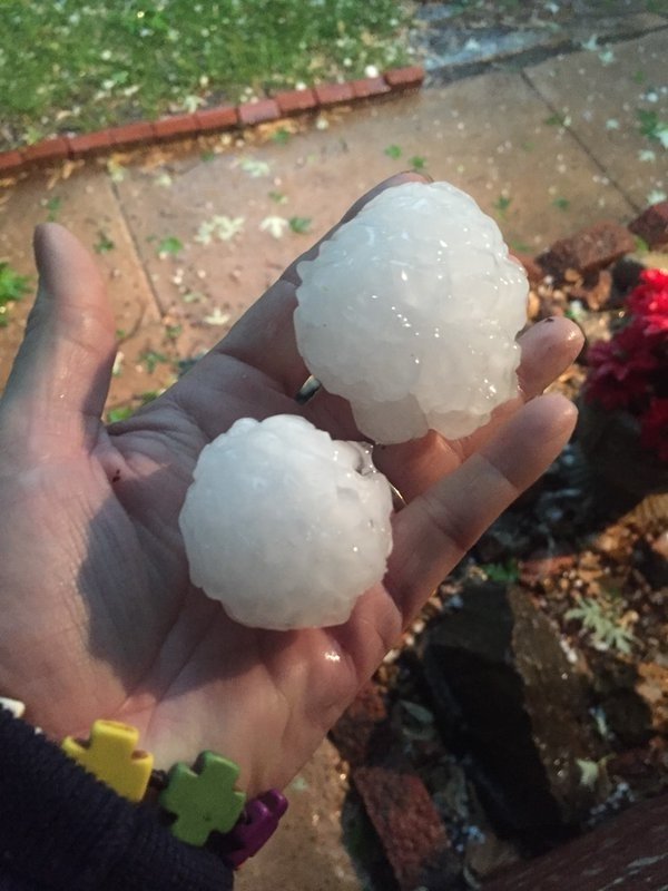
By late afternoon, the sky began dropping icy stones the size of grapefruits, smashing into roofs and threatening to damage agricultural crops. The hail was not reported to have caused injuries — but fruit-sized ice gobs do not go down gently. A car dealer in Oklahoma City, fearing for his vehicles, began parking cars indoor earlier in the day, the Associated Press noted. Other car owners weren't so lucky, and the large hailstones formed craters in hoods and windshields in northeast Kansas.
Once hail grows beyond three-quarters of an inch in diameter, the National Weather Service deems it "severe." And a grapefruit, if you haven't hefted one in the produce aisle recently, is a sizable citrus. The Ruby Red hybrid, the first grapefruit ever patented, back in 1927, is capable of growing up to 6 inches in diameter. Hail is, in fact, capable of getting as large: A hailstone 8 inches across and tipping the scales at nearly 2 pounds holds the distinction of being the biggest ever to fall in the United States, according to the National Oceanic and Atmospheric Administration.
It's likely the hail in Tuesday's storm wasn't quite as outsized — the National Weather Service, it turns out, has a rough guide for what it means when hail is the size of a certain common object. Pea-sized hail is a quarter inch in diameter, half-inch hailstones are marble-sized and penny-sized hail is when the stones become severe. (There's a fondness for coins, probably because most people know what a quarter — equivalent to an inch of hail — looks like.) Hail the size of grapefruits, per the National Weather Service, is about 4 inches across. And hope you never hear that softball-sized stones — boasting 4.5-inch diameters, the largest in the agency's estimation system — are falling.

A piece of hail can go through several of these cycles, floating up and down while collecting layers of water and ice, until the stone is too heavy for the wind to hold aloft. For hail to grow to softball sizes, wind speeds need to be near the 100-mph mark; Tuesday's storm, in comparison, had winds of about 70 mph.
Although hail is very rarely fatal in the United States, falling ice wreaks significant destruction. A hail storm that passed over an outdoor Dallas festival in 1995 injured 400 and caused an estimated $2 billion in damage in two counties.
To predict when and where severe hail will fail, meteorologic researchers like those at the University of Oklahoma have developed complex computer models. The Oklahoma model is particularly intensive, meshing the effects of sun radiation and rainfall physics with complex fluid dynamics equations over a geographic grid of a million points. Though their program currently requires one of the most powerful supercomputers in the country to run, the scientists hope — in a few years' time, anyway — that such a model could give hours of warning before grapefruit-sized hail starts to fall.


Reader Comments
Yep-Baron. And how about some objectivity in reporting?
If those were 'grapefruits,' in that picture, they were the tree's runts or more like tangerine sized. How about mere diameter and weight? (I seem to remember a time when hail was compared with the (relatively) fixed size of coins, beyond which the reporting would say something like "up to 1&3/4 or 4 cm in diameter, about the size of a golfball, etc."
Why is that so hard these days? Is the press just getting lazier? (As if that were possible?)
R.C.
A small increase in the temperature difference between the cool air and the warm, causes a big increase in windspeed. And the force of the wind is square to the increase in speed. Double the windspeed of the updraft and get 4 times the lifting ability, or 4 times the weight of hail produced. We could soon be seeing 30 to 60 pound hail. Now that would be damaging.