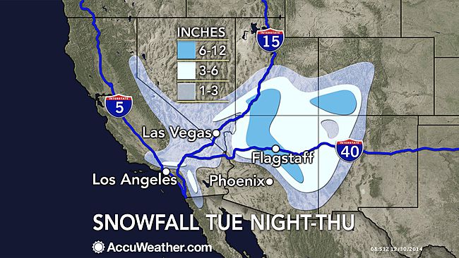
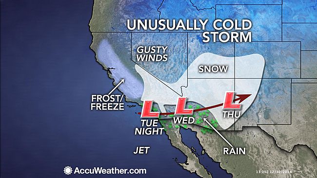
As cold air continues to plunge southward in the West, a storm will produce rare New Year's Eve and New Year's Day snow for Las Vegas, the Mojave Desert and the mountains in the region.
Pack some warm clothes and perhaps winter boots if you are heading to the Southwest for the New Year's holiday. Motorists heading over the mountains should expect delays due to snow-covered roads.
Soon after snow falls on parts of the central Rockies and Plains, a new winter storm will develop over the Southwest states.
The storm will bring snow to not only the mountains of the Four Corner states, Nevada and Southern California, but also some low-elevation locations in the region that rarely receive accumulating snow.
Las Vegas, which averages about 0.3 of an inch of snow per year, is forecast to receive 1-3 inches of snow during Tuesday night into Thursday morning.
According to the Las Vegas National Weather Service Office, there have only been 15 snowstorms that brought greater than 1 inch of snow. Records have been kept since 1937.
If 0.1 of an inch of snow or more falls on Las Vegas on Wednesday, it will become the snowiest New Year's Eve in the city's record.
The last and only snowstorm on record during New Year's Day around Las Vegas was in 1974, when accumulations ranged from 2 to 5.5 inches in the area. The official New Year's Day record for McCarran International Airport is 4.4 inches.
"Unusually cold air will target the southwestern U.S. by midweek. Las Vegas has not seen measurable snow since Dec. 17, 2008, when 3.6 inches of snow fell," said AccuWeather.com Senior Meteorologist Dave Samuhel.
If the winter storm materializes in Las Vegas, the city could wind up with more snow than a number of locations in the Midwest and mid-Atlantic this December.
In order for roads to become covered with snow, the snow would have to fall at a very heavy rate during the day or snow at night. Motorists should be prepared for slippery spots and airline passengers should anticipate flight delays due to poor visibility and deicing activities.
As the storm spins over the Southwest, snow will fall in the higher elevations of Southern California. There is the potential for icy and snow-covered roads over Cajon and Tejon passes from Tuesday evening through Wednesday.
"Snow levels will be down to 2,500 feet (by midweek) and the Antelope Valley in the upper deserts outside of Los Angeles could have measurable snow as well," continued Samuhel.
During Wednesday and Wednesday night, motorists should expect travel delays and possible road closures along portions of I-40 in Arizona and New Mexico, where a half a foot of snow or more may fall.
Motorists may want to consider taking a more southern route, such as I-10, during this time.
It is possible that wet snowflakes and sleet will mix in with the rain around Phoenix and Yuma, Arizona, and Palm Springs, California.
This cold regime will be firmly entrenched across the West, so people partaking in outdoor New Year's Eve festivities will need to bundle up. Temperatures will plunge below zero in Montana and highs will only be in the 30s in part of the Southwest deserts.
Content contributed by Senior Meteorologist Alex Sosnowski.


Comment: To understand what's going on with our wild weather, check out our recently published book, Earth Changes and the Human-Cosmic Connection, available here. Also, check out November's Earth Changes Video Summary for more crazy weather happenings on the planet.
SOTT Earth Changes Video Summary - November 2014