© Weather.com
Winter storm warnings and winter weather advisories are posted for parts of the Appalachians and snow advisories are in effect in the Great Lakes as the season's first snow targets those areas from Halloween into the weekend.
As of Friday morning up to
8 inches of snow fell in Winchester, Wisconsin and near Three Lakes, Michigan. Wind gusts up to 60 mph have also been reported in parts of Michigan.
Snow Timing Given the expected intensity of a southward plunge of the jet stream and the magnitude and depth of cold air pulled with it, we're not simply talking about chilly rain showers, but also accumulating snow for some as well as the first flakes of the season for others.
- Friday: The cold front plunges through the Great Lakes early, then through the Ohio Valley and Appalachians. Rain will mix with, or changeover to wet snow in parts of Michigan and Wisconsin and spread to the Ohio Valley and Appalachians later in the day into the night. Bands of lake-effect rain or snow will also set up.
- Saturday: Additional snow will fall over the Appalachians and parts of the piedmont from east Tennessee and western North Carolina (possibly Upstate South Carolina) north to at least West Virginia. Some wet snow may also linger in parts of eastern Lower Michigan, Ohio, western Pennsylvania, western New York. Snow may develop later in parts of northern New England.
-
Sunday: Snow, possibly heavy, in parts of northern New England and gusty winds are expected as well.
Heavy snow and high winds into Monday and early Tuesday in parts of Atlantic Canada, from New Brunswick to Labrador.
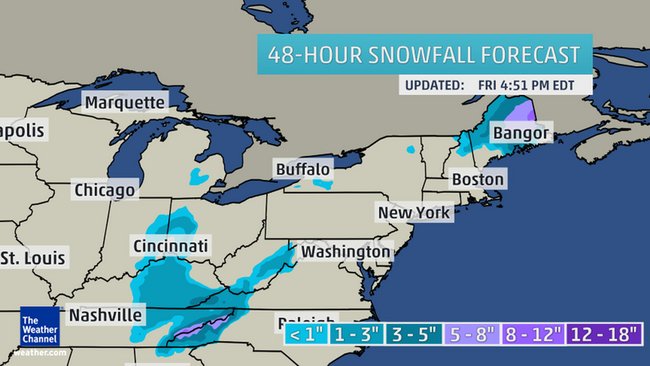
How Much Snow? Keep in mind additional snow may fall beyond the 48-hour window shown in the map. Here are the highlights of that forecast:
-
Accumulating snow likely: U.P. and northern Lower Michigan, northern Wisconsin, Appalachians from West Virginia to east Tennessee, western North Carolina, and the mountains of northern New England. A few areas of the Appalachians may pick up 6 inches of snow, or locally more. Totals over 6 inches are possible in parts of Maine (northern or eastern).
-
Some chance of accumulating snow: Parts of eastern Wisconsin, southern Lower Michigan, Indiana, Ohio, eastern Kentucky, western/northern Pennsylvania, western/central New York, piedmont of North Carolina, Upstate South Carolina,
-
Some possible season's first flake cities: Marquette, Detroit, Cleveland, Cincinnati, Indianapolis, Charleston (WV), Asheville, Caribou (ME)
Be prepared for hazardous winter driving conditions, particularly on bridges or overpasses, if you have plans to check out the fall foliage in the Appalachians this weekend.
Also, with low pressure intensifying off the Eastern seaboard this weekend, the combination of strong winds and wet snow accumulations may lead to some power outages and downed trees/tree limbs in parts of the Appalachians and northern New England.
Persistent strong winds off Lakes Superior and Michigan will also whip up some impressive waves along each lake's south shore. Lakeshore flood advisories have been posted, including in the lakefronts of Chicago and Marquette, Mich.
If the low-levels of the atmosphere are sufficiently cold enough,
a band of wet lake-effect snow may form Friday in northwest Indiana.
Even without any snow, it will be chilly and raw, with highs in much of the Great Lakes and Northeast holding in the 40s, or even 30s in some spots.
Is This Snow Early?In almost all locations, this will not be the earliest measurable (at least 0.1 inches) snow on record in the Great Lakes, Appalachians or northern New England. Here are some factoids about the season's first snow.
The beginning of the end (Ragnarök) starts with three successive, and extremely cold, winters...
[Link]
Surely feels like it!!!