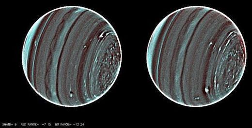
"My first reaction to these images was 'wow' and then my second reaction was 'WOW,'" said Heidi Hammel, a co-investigator on the new observations. "These images reveal an astonishing amount of complexity in Uranus' atmosphere. We knew the planet was active, but until now much of the activity was masked by noise in our data."

With its beautiful blue atmosphere, Uranus can seem rather tranquil at first glance. Even the flyby of Voyager 2 in 1986 revealed a rather "bland" blue ball. But coming into focus now with the new are large weather systems, and even though they are probably much less violent than storms on Earth, the weather on Uranus is just...bizarre.
"Some of these weather systems," said Larry Sromovsky, from the University of Wisconsin-Madison who led the new study using the Keck II telescope, "stay at fixed latitudes and undergo large variations in activity. Others are seen to drift toward the planet's equator while undergoing great changes in size and shape. Better measures of the wind fields that surround these massive weather systems are the key to unraveling their mysteries."
Sromovsky, Hammel and their colleagues are using new infrared techniques to deliver some of the "most richly detailed views of Uranus yet obtained by any instrument on any observatory. No other telescope could come close to producing this result," Sromovsky said.
What they are seeing are previously undetected, small but widely distributed weather feature, and they hope the movements of these features can help make sense of the planet's odd pattern of winds.
They observed a scalloped band of clouds just south of Uranus' equator and a swarm of small convective features in the north polar regions of the planet. Features like this don't seem to be in the southern polar regions, but are similar to the types of "popcorn" - type clouds seen on Saturn. Uranus' north pole is not visible from Earth night now, but when it does come into view, the researchers wouldn't be surprised to see a polar vortex feature similar to what has been seen at Saturn's south pole.
The driver of these features must be solar energy because there is no other detectable internal energy source.
"But the Sun is 900 times weaker there than on Earth because it is 30 times further from the Sun, so you don't have the same intensity of solar energy driving the system," said Sromovsky. "Thus the atmosphere of Uranus must operate as a very efficient machine with very little dissipation. Yet the weather variations we see seem to defy that requirement."
One possible explanation, is that methane is pushed north by an atmospheric conveyor belt toward the pole where it wells up to form the convective features visible in the new images. The phenomena may be seasonal, the team said, but they are still working on trying to put together a clear seasonal trend in the winds of Uranus.
"Uranus is changing," he said, "and there is certainly something different going on in the two polar regions."
The images were released at the American Astronomical Society's Division for Planetary Sciences meeting taking place this week.
Source: University of Wisconsin-Madison


..."a thick, tempestuous atmosphere with winds blowing at a clip of 900 km/h (560 mph); massive storms that would engulf continents here on Earth, and temperatures in the -220 C (-360 degree F) range"...
..." large weather systems, and even though they are probably much less violent than storms on Earth, the weather on Uranus"...