Severe thunderstorms rumbled into Southern New England beginning at daybreak on Wednesday and continuing at 11 a.m. for a second round, clustering together over the southernmost tip of Rhode Island with wave after wave of heavy rain and lightning strikes.
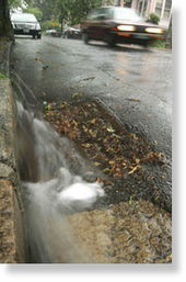
Roads flooded and left motorists stranded in their swamped cars. Lightning struck houses from Westerly to Coventry. Torrential downpours - - at times about an inch an hour - - overwhelmed drainage systems, forcing street and highway closures in parts of South County. The rain gauges used by engineers at the Department of Transportation showed 4 inches of rain fell in just two hours in Charlestown - - approaching levels of a hundred-year storm, said department spokesman Charles St. Martin.
Westerly got the worst of it.
The seaside town logged 5.2 inches of rainfall in just a few hours, more than the amount of rain that fell all last month, said National Weather Service meteorologist Alan Dunham.
Downpours flooded out all of the main roads in Westerly, sending police officers and firefighters wading after stranded motorists and bringing them back to the Westerly fire station to get dry, said Police Chief Ed Mello. The floods forced road closures throughout the town, including Route 78, Main Street, Airport Road and Route 1, which was closed through part of Charlestown for more than an hour in mid-day.
Power was knocked out at the traffic lights on Route 1 and along Charlestown Beach, and the storm toppled a tree across Burdickville Road, said Charlestown Emergency Management Director Kevin Gallup.
Public works crews were out clearing storm drains so the water could recede, he said, but the drains were dealing with a lot of rainfall in a short amount of time.
As he watched the rain pummel the ground, Gallup said, "It's a mess here."
At the height of the storm at around noontime, about 3,200 National Grid customers lost power - - mostly in Richmond and Westerly, a spokeswoman for the utility said.
Lightning struck a man in West Greenwich, a bus in West Warwick and hit houses in Coventry, West Greenwich and Westerly, according to the National Weather Service. The West Greenwich man was "shaken up," said the police, and was taken to Rhode Island Hospital for treatment.
In Newport, where more than half of its total 2.06 inches of rainfall came in just one hour, First Beach and part of Memorial Boulevard had to be closed because of high water, said Police Chief Michael McKenna. "We've got a lot of water all over town," he said, as the second storm was passing.
The sky was dark in Providence, but the city and surrounding metro area were largely spared. After the second string of storms marched through mid-afternoon, 1.92 inches of rainfall was recorded at T.F. Green Airport, in Warwick, Dunham said.
In June, Rhode Island had 3.61 inches of rain, just slightly more than the 3.38 inches considered normal, Dunham said. Clouds upstaged rain most days, with 17 out of 30 days bringing measurable precipitation, he said.
It was the ninth-coolest June on record, tying with 1927 and 1902 with 64.4 degree days on average, Dunham said.
For Thursday, expect more of the same: showers, thunderstorms, and a flash-flood watch through the evening.
Still, Independence Day may have an unfamiliar glow in the sky.
Not fireworks.
The sun. The deluge
Rainfall amounts around the state:
Westerly: 5.2 inches
Charlestown: 4 inches
Newport: 2.06 inches
T.F. Green: 1.92 inches


Reader Comments
to our Newsletter