Earthquakes
S


Attention

California's Anderson reservoir is so full it's seismically unsafe

Anderson Dam
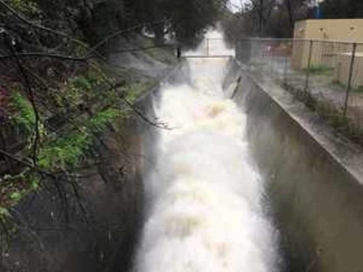
© Michael MooreThe outlet pipe at the bottom of Anderson Dam, pictured Feb. 9, has been wide open since early January.
South Bay water officials are urgently trying to lower a reservoir to reduce pressure on a shaky dam.

The Anderson Reservoir in Morgan Hill is just a couple of miles east of U.S. Highway 101.

The dam is especially vulnerable right now if an earthquake happens to strike.

Water gushes from the bottom of the Anderson Dam. The release valve is wide open and crowds are coming to see what looks like a water show.

Sean Barragan, of Morgan Hill, said, "It's pretty awesome. It's not a thing you see every day."

But it's not just for show.

The water district is trying to quickly lower the level of the reservoir, because it's not seismically safe to be as full as it is now.

A 2009 study found a large earthquake next to the dam could cause a failure.

Since then state regulators placed a cap on the dam at 68 percent of capacity.

But the recent rains have boosted the level to 91 percent of capacity.
Comment: State officials are also concerned with another California dam:


Seismograph

Very shallow 5.6 magnitude earthquake hits southern Taiwan

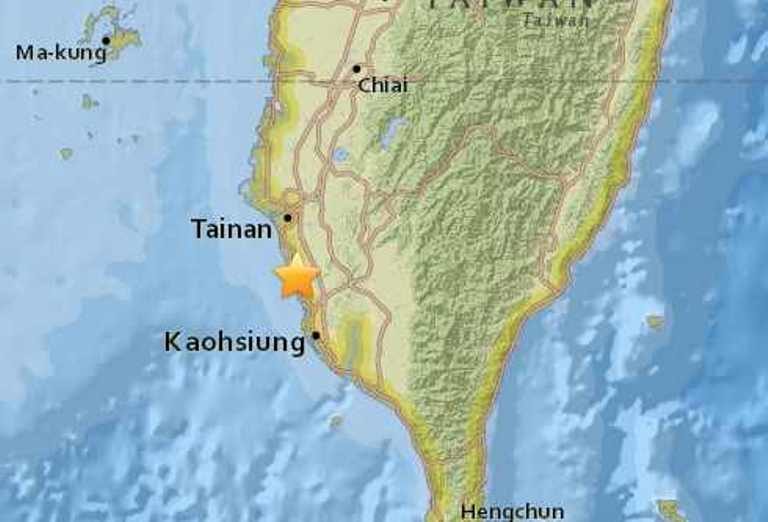
Taiwan quake map
© USGS
The earthquake, which struck at 1:12 a.m. local time on Saturday, was centered about 19 kilometers (12 miles) south of Tainan, or 23 kilometers (14 miles) northwest of Kaohsiung. It struck at a depth of 18 kilometers (11 miles), making it a very shallow earthquake.

Both the Taiwan Central Weather Bureau and the U.S. Geological Survey (USGS) put the magnitude of Saturday's earthquake at 5.6. The Central Weather Bureau said shaking was felt across southern and central parts of the island, with the strongest shaking in Tainan City and Kaohsiung City.

While it was not immediately known whether the earthquake had caused damage or casualties, several residents described their experiences. It was a "very sudden large jolt," one resident near the epicenter told the seismological agency EMSC, while a second resident called it "pretty scary."

Located along the so-called Pacific Ring of Fire, Taiwan is at times rattled by moderate to strong earthquakes. A powerful 7.6-magnitude earthquake struck central Taiwan in September 1999, killing at least 2,297 people and injuring nearly 9,000 others.

More recently, a 6.4-magnitude earthquake struck southwest Taiwan on February 6, killing 117 people and injuring more than 500 others.

Blue Planet

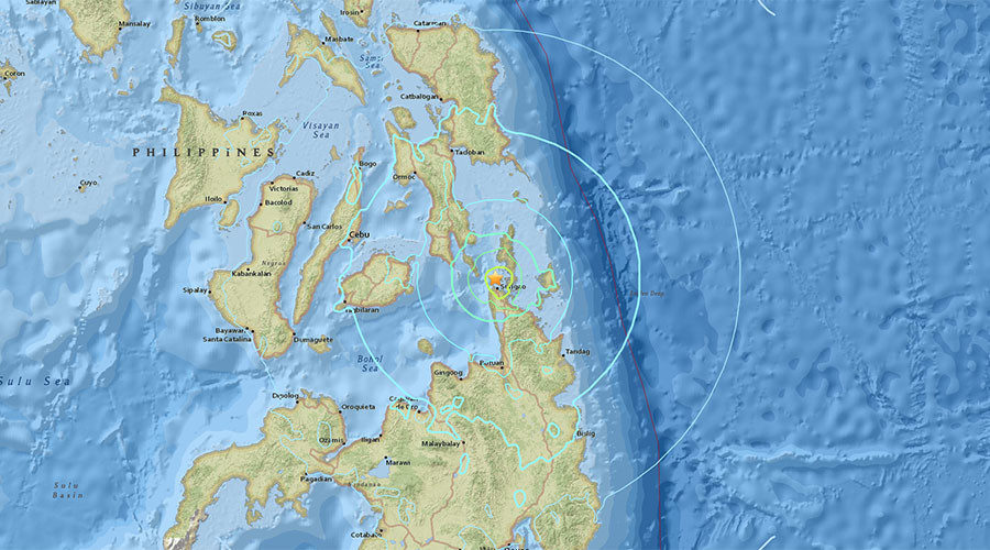
USGS: Earthquake measuring 6.7 hits south Philippines, no tsunami warning

Philipines earthquake
© USGS
An earthquake measuring magnitude 6.7 has struck near Mindanao Island in southern Philippines, the United States Geological Survey has reported. No tsunami warning has been issued, according to the National Oceanic and Atmospheric Administration.

The epicenter of the earthquake occurred at a depth of 10km (6 miles) and about 13km (8 miles) east of the city of Surigao, located on the northeast of the island, which is the second biggest in the Philippines, according to Reuters.

Tremors were also reportedly felt in a number of nearby areas, including the Philippines' second city, Cebu City, and Talisay City.

USGS data

Blue Planet

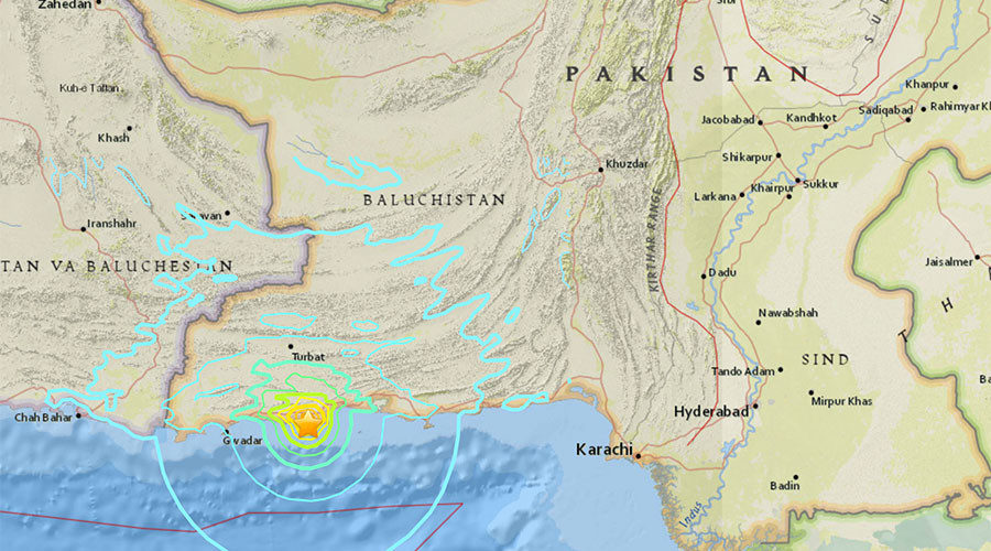
6.3 earthquake strikes off southern Pakistan

Pakistan earthquake
© earthquake.usgs.gov
A powerful 6.3-magnitude earthquake has hit off the southern coast of Pakistan, the US Geological Survey reported.

The quake, which was originally registered as magnitude 6.6, hit 23 kilometers southwest of the city of Pasni at a depth of 10 kilometers. The cities of Turbat and Gwadar are also within 90 kilometers from the epicenter of the quake.

Bizarro Earth

Four of Iceland's volcanoes are priming to erupt - Katla, Hekla, Bárðarbunga, and Grímsvötn

Páll Einarsson
© mbl.is/Ómar ÓskarssonHekla, Grímsvötn, Bárðarbunga and Katla are all preparing for eruption.
As we all know, Iceland is a profoundly volcanic place with a variety of eruption styles - from spewing out a little or a lot of lava, to exploding so violently that Europe gets blanketed in ash.

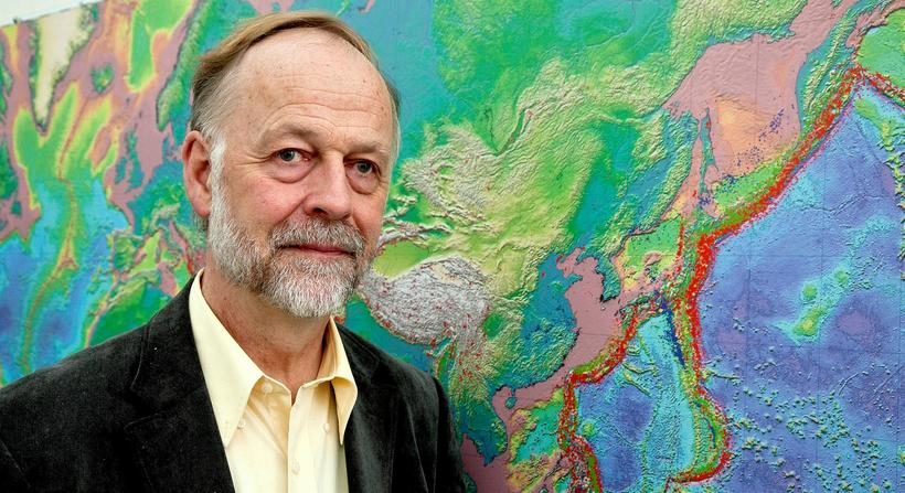
Well, as reported by the Iceland Monitor, the nation's soothsaying geophysicist Páll Einarsson claims that four of the country's angry mountains are exhibiting pre-eruptive conditions. Apart from that, however, little information has been given.

The volcanoes in question are Katla, Hekla, Bárðarbunga, and Grímsvötn. With no data or references given in the post, we decided to do a little digging ourselves.

So what of Katla? Well, it's a rather sizable volcano that has indeed been showing signs of restlessness recently, with tremors hitting around the 4.6M mark. These quakes are possibly indications of magma ascending upwards through the crust and causing it to violently fracture, but as of yet, there's no definitive proof of this.

Seismograph

Ankara mayor warns of technology triggering man-made earthquakes

Mayor Melih Gokcek
© AFP/Adem AltanAnkara Mayor Melih Gokcek
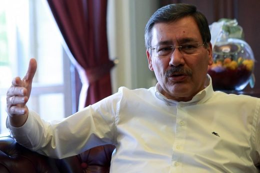
Ankara's outspoken mayor on Tuesday warned that outside forces could be using sophisticated technology to try to trigger a manmade earthquake in a deliberate bid to harm Turkey's fragile economy.

Melih Gokcek, who has been mayor of the Turkish capital since 1994, made the outlandish claims on Twitter where he regularly updates his more than 3.7 million followers, often writing in capital letters.

His comments were made after two quakes hit the western Canakkale province on Monday and Tuesday morning, measuring 5.3 and 5.2 magnitude respectively, the Turkish Disaster and Emergency Management Authority (AFAD) said.

In these tweets, Gokcek shared a video which claimed there were tools for causing manmade quakes, and he called all submarines and ships with large equipment to be taken under control of the authorities.

Comment: As evidenced in our 2010 article, Connecting the Dots: Mass murder in Haiti, plane madness in the skies, 'man-made' earthquakes as a means of warfare is not a fantastical or outlandish claim.
Israel has certainly chosen an interesting time to announce ongoing "research into how earthquakes are formed" by inducing earthquakes, while the Pentagon announced February 7 that it was planning further "earthquake simulations", beginning in Alaska sometime this spring.

We've seen since 9/11 that the US government has no qualms obliterating whole countries through "creative destruction", leaving millions dead and wounded in the wake of its imperialistic goals and thirst for oil. If it had the means to cause earthquakes at specific locations, would it be shy about using it? Many are suggesting HAARP as the likely culprit, but the high amounts of concentrated energy required to cause an earthquake at a specific location may require a more precise method of delivery. Perhaps a good place to start looking is space-based weapons. Reagan's Strategic Defense Initiative "Star Wars" program didn't die with the Soviet Union. In fact, the "Evil Empire" was the justification for the real Evil Empire to construct technologies that would enable it to control the whole planet:
"Environmental warfare is defined as the intentional modification or manipulation of the natural ecology, such as climate and weather, earth systems such as the ionosphere, magnetosphere, tectonic plate system, and/or the triggering of seismic events (earthquakes) to cause intentional physical, economic, psycho-social, and physical destruction to an intended target geophysical or population location, as part of strategic or tactical war." (Eco News)
As far back as 1955 John von Neumann said that "Intervention in atmospheric and climatic matters... will unfold on a scale difficult to imagine at present... this will merge each nation's affairs with those of every other, more thoroughly than the threat of a nuclear or any other war would have done." In 1977, the nations of the world were obviously aware of the dangerous implications of the Pentagon's development of "environmental modification techniques" because an international Convention was ratified by the UN General Assembly banning "military or other hostile use of environmental modification techniques", which it defined as "any technique for changing - through the deliberate manipulation of natural processes - the dynamics, composition or structure of the earth, including its biota, lithosphere, hydrosphere and atmosphere, or of outer space."

The Pentagon is (or was, until its report was taken offline) on record as having claimed the ability to modify terran and space weather as part of its strategic arsenal:
"[Weather modification] offers the war fighter a wide range of possible options to defeat or coerce an adversary... Weather modification will become a part of domestic and international security and could be done unilaterally... It could have offensive and defensive applications and even be used for deterrence purposes. The ability to generate precipitation, fog and storms on earth or to modify space weather... and the production of artificial weather all are a part of an integrated set of [military] technologies." (US Air Force document AF 2025 Final Report)
In April 1997, then-Defense Secretary William Cohen, answering a journalist's question about an apparently unrelated topic at a conference on terrorism, slipped in some curious remarks about the type of weapons available to those bent on terrorising humanity. The following exchange is taken verbatim from a transcript posted on the Department of Defense website, which used to found here:
Q: Let me ask you specifically about last week's scare here in Washington, and what we might have learned from how prepared we are to deal with that (inaudible), at B'nai Brith.

A: Well, it points out the nature of the threat. It turned out to be a false threat under the circumstances. But as we've learned in the intelligence community, we had something called -- and we have James Woolsey here to perhaps even address this question about phantom moles. The mere fear that there is a mole within an agency can set off a chain reaction and a hunt for that particular mole which can paralyze the agency for weeks and months and years even, in a search. The same thing is true about just the false scare of a threat of using some kind of a chemical weapon or a biological one. There are some reports, for example, that some countries have been trying to construct something like an Ebola Virus, and that would be a very dangerous phenomenon, to say the least. Alvin Toeffler has written about this in terms of some scientists in their laboratories trying to devise certain types of pathogens that would be ethnic specific so that they could just eliminate certain ethnic groups and races; and others are designing some sort of engineering, some sort of insects that can destroy specific crops. Others are engaging even in an eco- type of terrorism whereby they can alter the climate, set off earthquakes, volcanoes remotely through the use of electromagnetic waves. So there are plenty of ingenious minds out there that are at work finding ways in which they can wreak terror upon other nations.


Seismograph

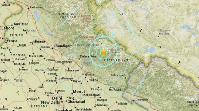
5.8 magnitude earthquake hits northern India, tremors felt in Delhi

Uttarakhand earthquake
© earthquake.usgs.govThe epicentre of the earthquake is being reported to be Uttarakhand in Northern India.
A moderate intensity earthquake measuring 5.8 on Richter Scale today hit Uttarakhand, tremors of which were felt in Delhi and other parts of northern India.

The epicentre of the quake was Rudraprayag district in Uttarakhand, said J L Gautam, Operations head at the National Seismological Bureau, a unit of Ministry of Earth Sciences.

"The depth of the quake was 33 km and it occurred at 10.33 PM," he said.

Uttarakhand, which falls in the Himalayan belt, is known for high seismic activities.

Tremors were felt across Punjab, Haryana and their common capital Chandigarh also after which many people rushed out of their homes.

There were no immediate reports of any loss of life or damage to property.

Seismograph

Strong shallow 5.6 magnitude earthquake rattles parts of Colombia

GRAPH
A shallow, 5.6-magnitude earthquake rattled residents of Colombia's largest city on Monday, leading office workers to evacuate buildings and forcing the city's airport to temporarily close.

The earthquake struck shortly after 8 a.m. local time and was centered in the department of Huila, about 185 miles (300 kilometers) southwest of the capital. It had a depth of 23 miles (37 kilometers), according to the U.S. Geological Survey.

President Juan Manuel Santos said there were no immediate reports of damage.

It was the biggest earthquake to hit Colombia since a 5.9-magnitude tremor last September.

Seismograph

Two shallow magnitude 3.2 earthquakes shake Napa County, California

Two magnitude 3.2 earthquakes struck near Angwin in Napa County on Monday morning, February 6, 2017 at 6:02 and 6:08 AM.
© USGS Two magnitude 3.2 earthquakes struck near Angwin in Napa County on Monday morning, February 6, 2017 at 6:02 and 6:08 AM.
The United States Geological Survey reports two preliminary magnitude 3.2 earthquakes struck near Angwin in Napa County on Monday morning.

The first quake hit at 6:02 AM at a depth of 7 kilometers. A second quickly followed at 6:08 AM at a depth of 8 kilometers.

There was no initial word on damage or injury resulting from the quake. More information on this earthquake is available on the USGS event page.

See the latest USGS quake alerts, report feeling earthquake activity and tour interactive fault maps in the earthquake section.

Seismograph

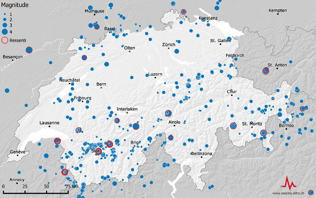
More earthquakes than usual shook Switzerland last year

Switzerland's earthquakes in 2016.
© Swiss Seismological ServiceSwitzerland's earthquakes in 2016.
Switzerland experienced 880 earthquakes in 2016, slightly more than the 40-year average, according to the Swiss Seismological Service (SED).

The service, which is run by federal technology institute ETH Zurich, said 31 of those registered above 2.5 on the Richter scale, more than the average of 23.

As usual the cantons of Valais and Graubünden were the most affected areas of the country.

Medium-sized earthquakes registering 3 or more on the Richter scale hit Juf in the canton of Graubünden - Europe's highest year-round inhabited village - Saint-Gingolph on the shore of Lake Geneva and an area on the Swiss-French border near Martigny in the Valais.