Earthquakes
S


Attention

Mysterious oarfish sightings stoke earthquake fears in the Philippines (PHOTOS)

Mysterious oarfish sightings stoke earthquake fears in the Philippines (PHOTOS) February 19 2017
© Jude Cyril Roque Viernes / Facebook
Three oarfish, which normally live deep near the ocean floor, have been found in the Philippines, sparking fears among locals that it may be a sign of an impending large earthquake.

Oarfish, which can grow to over 56 feet (17 meters) in length, are usually found at depths of between 200 to 1,000 meters, but since February 8, three have been found off the northern coast of Mindanao island, in the south of the archipelago.

The latest leviathan was found on Saturday on a beach in the city of Cagayan de Oro, measuring around 15 feet long, though it later died, according to ABS.


Comment: Also see: A few more noted sightings of this elusive and ominous fish from 2016 from around the globe:


Seismograph

Maui earthquake triggers widespread reports of shaking

earthquake hawaii
Maui County residents felt a 4.6-magnitude earthquake that struck at 5:33 a.m. Friday between Maui and Hawaii island.

The Pacific Tsunami Warning Center determined that no tsunami was generated.

Wailuku resident Mahina Martin said: "I was awake and felt the house trembling. Then I noticed some things on a shelf shaking, which is when I realized it was probably an earthquake."

Seismograph

6.3 magnitude earthquake hits northern Argentina

The earthquake measured 6.3 on the Richter scale, according to scientific monitoring services
An earthquake believed to measure 6.3 on the Richter scale has struck in northern Argentina, close to the border with Chile.

Scientific monitoring service EMSC said the quake happened in the Jujuy region of the south American country today.

And government agency the United States Geological Survey (USGS) reports it happened 50km northwest of San Antonio de los Cobres, Argentina.

It said: 'There is a low likelihood of casualties and damage.'

Seismograph

Two earthquakes hit the province of Aceh, Indonesia in quick succession

GRAPH
Two earthquakes hit the Indonesian province of Aceh on Thursday (Feb 16) in an area that was struck by an earthquake in December.

The quakes measured at magnitude 5.1 and 5.6 by the United States Geological Survey (USGS) hit in quick succession not long after 3am on Thursday, reported AP.

The Indonesian Red Cross said two houses collapsed in Pidie Jaya near the epicenter and at least nine people were injured in Trianggadeng district, while power was knocked out in several areas.

The Dec 7 earthquake killed more than 100 people and destroyed or damaged more than 11,000 buildings, mostly homes.

Indonesia's meteorology and geophysics agency said there was no potential for a tsunami from Thursday's quakes.

Seismograph

Southern California's Ventura-Pitas Point fault line has potential to trigger earthquakes, tsunamis

S. California
© Patrick T. Fallon / Reuters
New research has revealed that a fault in Southern California which was only identified as active in the 1980s has the potential to trigger devastating earthquakes and tsunamis along America's south west coast.

The Ventura-Pitas Point Fault runs under California from Ventura city through the Santa Barbara Channel and beneath Santa Barbara and Goleta. It also runs offshore, meaning it may be capable of generating tsunamis.

Since it was identified as a potentially dangerous fault in the late 1980s, there have been decades of debate about its exact location and its underground geometry. Initial theories assumed the fault was slightly dipping, or that it had two severe tilting sections with a flat section in between, similar to a staircase.

A new study published in Geophysical Research Letters states that the fault has the staircase-like geometry, meaning it is closer to the surface and would likely cause more damage during an earthquake than previously thought.

Seismograph

At least 749 earthquakes have hit the Dardanelles, Turkey since February 6

Earthquake
© AA
At least 749 earthquakes have hit the Marmara province of Çanakkale since Feb. 6, the Disaster and Emergency Management Authority (AFAD) has stated.

The first wave of the earthquakes was recorded on Feb. 6 at 6:51 a.m. in the province's Ayvacık district with a 5.3-magnitude temblor. That was followed by another one with the same magnitude at 13.58 p.m. on the same day, and the latest major quake occurred in Ayvacık on Feb. 12 with the same magnitude, according to AFAD.

A number of buildings in the region were damaged and many locals settled in tent cities set up near the village of Yukarıköy, which was severely damaged by the quakes.


AFAD and the Turkish Red Crescent are currently setting up a container city for victims in the area.

Hourglass

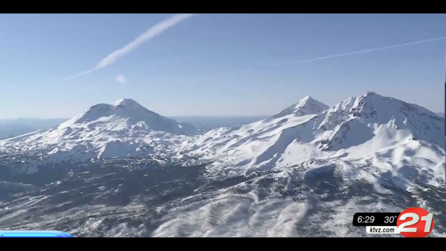
Cascade Range volcanoes: When, where's the next eruption?

Cascade mountain range
© KTVZ
A look at C.O., NW volcanic, earthquake activity

The Cascade Range may seem quiet, but some of those mountains have a secret: they're still alive. Central Oregon is not only a volcanic region, but also holds the potential for earthquakes.

South Sister is one of many volcanoes in the Cascade Range that's still considered to be alive with activity.

"Many volcanoes in the Cascades are considered active volcanoes, even though they aren't erupting right now," said OSU-Cascades geology instructor Daniele McKay. "They've erupted recently in the geologic past, and since South Sister only erupted 2,000 years ago, which sounds like a long time to us, that's really just yesterday, geologically."

At 50,000 years old, South Sister has been erupting on and off since its formation. It's not an "if" the volcano will erupt again, but "when". The giant stirred in 2001 when an area three miles west of the summit began to rise at a slight rate only detectable by special satellite instruments. This ground uplift is what scientists call "The Bulge".

"For 'the bulge,' it wasn't an awakening -- but it was a tangible example that these volcanoes are in fact active," said Seth Moran, a seismologist with the U.S. Geological Survey. "These volcanoes have erupted every so often, and they are going to erupt again. But it's one thing to have this eruption record that paints a picture every 1,000 years, and it's another thing to have an actual event where there is magma moving up."
Comment: See also:


Seismograph

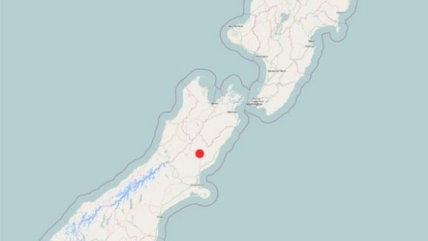
Shallow 5.2 earthquake shakes central New Zealand

The quake, which struck at 9.19am, was centred 15 km north-west of Culverden at a depth of 9km, GeoNet reported.
© GEONETThe quake, which struck at 9.19am, was centred 15 km north-west of Culverden at a depth of 9km, GeoNet reported.
A "severe" magnitude 5.2 earthquake in North Canterbury has been felt across the country.

The quake, which struck at 9.19am, was centred 15km north-west of Culverden at a depth of 9km, GeoNet reported.

It was felt widely. On GeoNet's site more than 1350 people lodged "felt it" reports.

GeoNet duty seismologist Dr Anna Kaiser said it was certain the shake was an aftershock from the big Kaikoura one on November 14.

"That's definitely within the aftershock area of the Kaikoura earthquake."

She said it was "very typical" to see that type of aftershock following a quake of the magnitude of the one in November.

As of January 19, GeoNet had predicted an 89 per cent chance of one or more aftershock between magnitude 5 and magnitude 5.9 occurring on the next 30 days.

Fish

Dead oarfish found off Mindanao, Philippines prior to seismic activity: Can animals predict earthquakes?

Dead oarfish was caught by fishermen off the coast of Agusan del Norte
Dead oarfish was caught by fishermen off the coast of Agusan del Norte.
The earthquake that jolted Surigao del Norte on Friday night jogged the memory of some people on social media, who were saying an incident two days prior could've served as a sign for the disaster that was about to strike.

On Wednesday, a 10-foot-long dead oarfish was caught by fishermen off the coast of Agusan del Norte.


To some, deep-sea creatures such as oarfish that end up in shallow water are a good predictor of earthquakes. How true that is remains very much a debate?

"It's theoretically possible because when an earthquake occurs there can be a build-up of pressure in the rocks which can lead to electrostatic charges that cause electrically charged ions to be released into the water," Rachel Grant, a lecturer in animal biology, said in a report posted on the Independent news website in October 2013.

In an undated Japan Times article, seismologist Kiyoshi Wadatsumi said that "deep-sea fish living near the sea bottom are more sensitive to the movements of active faults than those near the surface of the sea."
Dead oarfish
Dead oarfish

Comment: See also: USGS: Earthquake measuring 6.7 hits south Philippines, no tsunami warning


Attention

California's Anderson reservoir is so full it's seismically unsafe

Anderson Dam
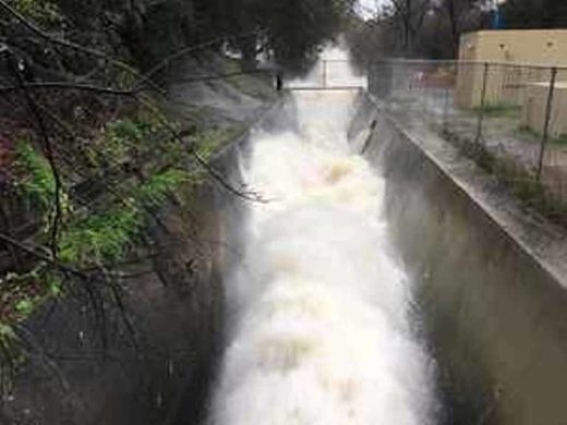
© Michael MooreThe outlet pipe at the bottom of Anderson Dam, pictured Feb. 9, has been wide open since early January.
South Bay water officials are urgently trying to lower a reservoir to reduce pressure on a shaky dam.

The Anderson Reservoir in Morgan Hill is just a couple of miles east of U.S. Highway 101.

The dam is especially vulnerable right now if an earthquake happens to strike.

Water gushes from the bottom of the Anderson Dam. The release valve is wide open and crowds are coming to see what looks like a water show.

Sean Barragan, of Morgan Hill, said, "It's pretty awesome. It's not a thing you see every day."

But it's not just for show.

The water district is trying to quickly lower the level of the reservoir, because it's not seismically safe to be as full as it is now.

A 2009 study found a large earthquake next to the dam could cause a failure.

Since then state regulators placed a cap on the dam at 68 percent of capacity.

But the recent rains have boosted the level to 91 percent of capacity.

Comment: State officials are also concerned with another California dam: