Earthquakes
S


Bizarro Earth

Strong 6.9 magnitude earthquake hits near Fiji

Nodi Island Earthquake
© Google Maps/USGS
A earthquake magnitude 6.9 (ml/mb) has struck on Friday, 283 km S of Ndoi Island, Fiji (176 miles). Exact location of event, depth 396.08 km, -178.845° West, -23.2032° South. The 6.9-magnitude earthquake was detected at 05:28:43 / 5:28 am (local time epicenter). Exact time and date of earthquake 24/02/17 / 2017-02-24 17:28:43 / February 24, 2017 @ 5:28 pm UTC/GMT. Id of earthquake: us20008m3t.

Event ids that are associated: at00olw37x, pt17055051, us20008m3t. The earthquake occurred at a depth of 396.08 km (246 miles) below the earth's surface. A tsunami warning has been issued near Ndoi Island in Fiji (Does not indicate if a tsunami actually did or will exist).

Each year there are an estimated 135 quakes in the world. Earthquakes 6.0 to 6.9 may cause a lot of damage in very populated areas. In the past 24 hours, there have been two, in the last 10 days three, in the past 30 days five and in the last 365 days fourty-three earthquakes of magnitude 3.0 or greater that was reported nearby.

Seismograph

Shallow earthquake of 5.2 magnitude strikes Manipur, India

GRAPH
A medium intensity earthquake measuring 5.2 on the Richter Scale hit Manipur on Friday evening.

The epicenter of the quake was in Churachandrapur district. It struck at 5:32 pm at the depth of 20 kms, according to the National Centre for Seismology, a unit of the ministry of earth sciences.

There were no immediate reports of loss of life or damage to property.

Another earthquake measuring 3.5 on the Richter Scale struck the Himalayan state of Sikkim at 3:09 am.

The northeast is known for its high seismic activity.

Source: Press Trust of India

Bizarro Earth

Slow-moving landslide slicing a hill in Abruzzo, Italy

abruzzo italy landslide
© Comune di Civitella del Tronto
Like the country didn't have enough natural disasters over the past several months, and years, yet another unstoppable disaster is affecting Italy's central region of Abruzzo, albeit rather slowly.

Civil authorities reported a slow-moving landslide is slicing a hill in the hamlet of Ponzano in Teramo in half, and a village, home to around 200 people, is at risk.

Several buildings have already collapsed or sustained severe damage as a result of the landslide, which is moving at a rate of about 1 meter per day (3.3 feet), but all of them are probably destined to collapse.

35 homes and a total of 120 people have been evacuated since February 12 when the slide was first detected. Residents said they had to evacuate within minutes.

Seismograph

Shallow 5.0 magnitude earthquake strikes North of Severnaya Zemlya, Russia

Russian quake map
© volcano discovery (screen capture)
Date & time: Thu, 23 Feb 20:13:40 UTC

Local time at epicenter: 2017-02-24 01:13:40 +05:00

Magnitude: 5.0

Depth: 10.0 km

Epicenter latitude / longitude: 86.1666°N / 74.4135°E [Map]

Nearest volcano: Unnamed 85.58°N/85.00°E (107 km)

Primary data source: USGS

Seismograph

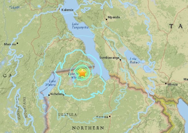
5.9 magnitude earthquake hits Zambia

Zambia earthquake map
© USGS
People in Zambia were shaken by a moderate earthquake Friday morning, but there were no immediate reports of injuries or significant damage.

The United States Geological Service measured the quake at a magnitude 5.9 on the Richter scale. The quake was centered 45 kilometers east of Kaputa, in the lakes region near the border with Democratic Republic of Congo. Its expected impacts also included the town of Nchelenge.

The quake occurred at about 2:30 a.m. local time, and was immediately felt to the west as well east in Tanzania.

"It woke up our children and the laying hens we keep in our yard woke up and starting crying out," said one Kaputa resident, reporting the earthquake to the Euro-Med Seismological Center (EMSC).

"The whole house shook. We couldn't walk straight," the testimony said. The EMSC put the magnitude slightly lower at 5.8 than the United States service did.

Messages posted to social media said many people awakened by the strong tremors were unable to go back to sleep.

Seismograph

Shallow magnitude 4.2 earthquake strikes near Belfair, Washington

Belfair quake map
© USGS

The Mason County Sheriff's Office and the USGS reported a magnitude 4.2 earthquake about 14 miles northwest of Belfair near the Hood Canal


The Mason County Sheriff's Office and the U.S. Geological Survey reported a magnitude 4.2 earthquake about 14 miles northwest of Belfair near the Hood Canal Wednesday night.

"We felt that one!" the sheriff's office tweeted just after the 9 p.m. temblor.

"We had some alarm systems go off, but no reports of slide or other damage as of now," the sheriff's office reported.

The U.S. Geological Survey reported the epicenter of the quake was about 14 miles west of Belfair on the southern end of the Kitsap Peninsula.

The quake was felt in part of Olympia and Shelton, the USGS said.

Comment: According to the USGS the earthquake depth was 16.6 km. A 4.8M quake has also been reported today 166km SW of Port Hardy, Canada at a depth of 10 km.


Seismograph

Swarm of nearly 300 earthquakes in Rotorua and Taupo, New Zealand

A swarm of nearly 300 quakes have been recorded in the Taupo and Rotorua areas.
© GEONETA swarm of nearly 300 quakes have been recorded in the Taupo and Rotorua areas.
Nearly 300 small earthquakes have been recorded in the Taupo and Rotorua areas since Monday last week, according to Geonet.

Geonet seismometers between Taupo and Tongariro National Park recorded the swarm of earthquakes, which are centred about 10km northwest of Tokaanu, near Turangi.

Since the quakes started on February 13 at 6pm, there have been 290 tremors. The largest was a magnitude 3.8 at 9.35pm yesterday.

Geonet said earthquake swarms were a sequence of many earthquakes striking in a relatively short time in a localised area. They are different from normal earthquakes followed by aftershocks because no single earthquake in the sequence is obviously the main shock.

Attention

Abnormal seismic swarm detected under Lanin volcano on the border of Chile and Argentina

Lanin volcano
© Hugo Moreno (University of Chile)Lanin volcano
An energetic seismic swarm has been detected under Lanin volcano on the border of Chile and Argentina, prompting the Chilean National Geological and Mining Service (Sernageomin) to raise the volcanic alert level to Yellow. The last known eruption of this volcano took place in the year 560 (± 150 years).

According to Sernageomin's special report issued February 15, a swarm of earthquakes, associated with the movement of fluids inside the volcano, started at 18:24 UTC and lasted 59 minutes and 45 seconds. The strongest earthquake had a magnitude 1.8.

No changes have so far been observed at the surface.

Sernageomin said the seismicity continued after they issued the report and estimated that there could be a destabilization of the volcanic system.

Given the relevance of this unusual activity, the agency has raised the alert level to Yellow.

This has activated the Civil Protection System and the notification to the Argentine Mining Geological Service to take measures to safeguard the population on both sides of the border.

Bizarro Earth

Strong 6.5 magnitude tremor strikes Bolivia

Bolivia Quake
© USGS
A strong earthquake (terremoto) with a preliminary magnitude of 6.5 has struck a mountainous region in central Bolivia, with shaking felt in Sucre, Potosi, Padilla and other cities across the region,.seismologists and residents say.

The earthquake, which struck at 10:09 a.m. local time on Tuesday, was centered about 40 kilometers (25 miles) east of the town of Padilla in the Chuquisaca Department, or 143 kilometers (89 miles) east of the city of Sucre. It struck at a depth of 596 kilometers (370 miles), making it a deep earthquake.

The United States Geological Survey (USGS) put the preliminary magnitude of Tuesday's earthquake at 6.5. The depth of the earthquake is likely to have minimized the effects of the quake and there were no immediate reports of damage or casualties.

Tuesday's tremor is the strongest tremor to hit Bolivia since November 2011, when a 6.6-magnitude earthquake struck southwest of Trinidad in north-central Bolivia.

We're working to gather more information.

Seismograph

Shallow earthquake shakes Panama with magnitude of 4.7

GRAPH
A strongly felt earthquake has swayed skyscrapers in Panama's capital and caused the evacuation of some buildings.

The U.S. Geological Survey gives a preliminary magnitude of 4.7 for Monday afternoon's quake.

The shaking set off car alarms and local news media said the local subway system was halted.

There are no immediate reports of injuries.

The 2:35 p.m. (1935 GMT) quake was centered 6 miles (10 kilometers) deep about 51 miles (83 kilometers) south-southeast of Panama City in the Gulf of Panama.

Source: AP