Earthquakes
S


Bizarro Earth

Earthquake Magnitude 5.0 - 28km E of Shimen, China

yunnan china
© USGS
Magnitude: 5.0 mb± 0.0

Location: 25.901°N 99.710°E± 7.7 km

Depth: 28.8 km± 4.6

Origin Time: 2017-03-26 23:55:06.860 UTC

USGS data

Comment: Almost 9,000 suffer from 5.1 magnitude earthquake in Yunnan, China


Seismograph

Almost 9,000 suffer from 5.1 magnitude earthquake in Yunnan, China

chart
About 8,960 people suffered from an earthquake that shook the province of Yunnan in the southwest of China earlier in the day, local media reported on Monday.

According to the CCTV broadcaster, about 2,000 households suffered in the earthquake, with some of local residents wounded lightly, but the exact number of the injured was not reported.

Many buildings reportedly showed cracks after the earthquake and lessons were canceled in schools.

According to other media reports, the earthquake had impacted 15,800 people and the consequences are still being addressed.

The earthquake of a 5.1 magnitude was registered at 7.55 a.m. local time (23:55 GMT on Sunday), with several weaker shocks following shortly after.

Bizarro Earth

Earthquake Magnitude 6.1 - 66km W of Attu Station, Alaska

attu island alaska
© USGS

Magnitude:
6.1

Location: 52.798°N 172.199°E± 6.7 km

Depth: 10.0 km± 1.8

Origin Time: 2017-03-27 10:50:19.270 UTC

USGS data

Seismograph

Magnitude 5.3 earthquake rattles Darwin, Australia after striking 600 km away in Banda Sea

Banda Sea earthquake map
© Geoscience Australia
An earthquake that struck this morning in the Banda Sea has rattled parts of Darwin but is unlikely to have caused any damage.

The magnitude 5.3 quake hit in the Banda Sea at a depth of 96 kilometres, about 600 kilometres north of Darwin.

Many people were asleep when it rattled parts of the city at 4:44am (ACST), but several people contacted ABC Radio Darwin to say they felt it.

Australia was a long way from the zone where damage was expected from the quake, according to information from Geoscience Australia.

Geoscience Australia seismologist Eddie Leask said quakes in the Banda Sea were often felt in Darwin.

"We had about 50 in that area over the last year and about 15 of those were felt in Darwin," Mr Leask told ABC Radio Darwin.

Bizarro Earth

New Zealand's earthquake most complex ever studied

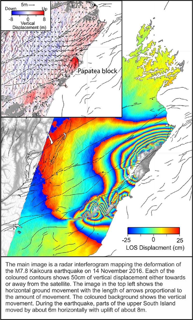
Interferogram Kaikoura
© GNS New Zealand
Last November's magnitude 7.8 Kaikoura earthquake was so complex and unusual that it is likely to lead to changes in the way scientists think about earthquake hazards in plate boundary zones worldwide, a new study says.

Not only was it a record-setter for its complexity, but it was also one of the best recorded large earthquakes anywhere in the world. This latter feature has enabled scientists to undertake analysis in an unprecedented level of detail.

The paper is the first of a number of studies to be published on the rich array of data collected during and immediately after the earthquake revealing its astonishingly complex nature.

Published today in the journal Science, the paper is titled 'Complex multi-fault rupture during the 2016 M7.8 Kaikoura earthquake, New Zealand'. Led by GNS Science and with 29 co-authors from 11 national and international institutes, it reports on the analysis of a range of quake data including satellite radar imagery, field observations, GPS data and coastal uplift data.

The authors say the quake has underlined the importance of re-evaluating how rupture scenarios are defined for seismic hazard models in plate boundary zones worldwide.

The study shows the quake moved parts of the South Island more than 5 metres closer to the North Island in addition to being uplifted by up to 8m.

Arrow Down

'Boom - it would drop': Earthquake could cause California land to sink rapidly, up to 3 feet

Scientists looking for charcoal
© fullerton.eduScientists look for microscopic charcoal to radiocarbon date mud samples collected from the Seal Beach wetlands.
Land within major California seismic faults could sink by between 1.5 and 3 feet in a matter of seconds, causing catastrophic devastation, says a new study. It also shows that the Newport-Inglewood fault is more active than previously thought.

"It's not just a gradual sinking. This is boom — it would drop. It's very rapid sinking," Robert Leeper, lead author of a new study published in Nature, carried out with the help of the US Geological Survey, told the LA Times.

Leeper's team took 55 samples at the Seal Beach National Wildlife Refuge in southern Los Angeles, by submerging 20-feet pipes that collected samples of the sediment, initially looking for evidence for a prehistoric tsunami.

Instead, the team from Cal State Fullerton found an identical pattern, of living vegetation suddenly dropping and being buried underneath the ground. "We identified three of these buried layers composed of vegetation or sediment that used to be at the surface," said Leeper.

Seismograph

5.5 magnitude earthquake shakes Bali, Indonesia

Bali earthquake March 2017
© USGS
An earthquake has hit Indonesia's resort island of Bali, causing some panic among residents, but there were no immediate reports of damage or casualties.

The United States Geological Survey said the magnitude 5.5 earthquake that struck at 7:10 a.m. Wednesday was centred two kilometres northeast of Banjar Pasekan, a town in the southeastern part of Bali, at a depth of 118 kilometres.

Witnesses said many residents and tourists ran out of their homes and hotels toward higher ground, but the situation returned to normal after they received text messages saying the quake had no potential to trigger a tsunami.

The Indonesian Meteorology, Climatology and Geophysics Agency measured the earthquake at 6.4 magnitude but said it would not cause a tsunami because the epicenter was so deep.

Indonesia is prone to the seismic upheaval due to its location on the so-called Pacific Ring of Fire. In December 2004, a massive earthquake off Sumatra island triggered a tsunami that killed 230,000 people in a dozen countries.

Seismograph

Shallow 4.0-magnitude earthquake jolts Islamabad, Pakistan

GRAPH
A 4.0-magnitude earthquake jolted Islamabad, Rawalpindi and surrounding areas on Tuesday, Pakistan Meteorological Department reported.

"The epicentre of the quake was near Hazro, Punjab and occurred at a depth of 12km," PMD said on Twitter.
An Earth Quake Originated on 10:57PST
Magnitude: 4.0
Depth: 12 Km
Lat: 33.89N
Lon: 72.54E
Epicenter: Near Hazro Punjab #Earthquake

— Pak Met Department (@pmdgov) March 21, 2017

Seismograph

Trinidad jolted by strong shallow tremor of magnitude 4.9

GRAPH
An earthquake with a magnitude of 4.9 jolted Trinidad and Tobago on Monday but there were no immediate reports of injuries or damage.

The Seismic Research centre (SRC) of the University of the West Indies (UWI), said that the quake, which occurred at 3:01 pm (local time) had a depth of 10 kilometres.

It said felt in Port of Spain and Arima as well as in Scarborough, the capital of Tobago.

The location of the quake was given as Latitude 11.26N and Longitude: 60.92W.

Seismograph

Shallow magnitude 6.0 quake strikes off the Solomon Islands

An earthquake of magnitude 6.0 hit off the Solomon Islands in the early hours of Monday.(Representative image)
A 6.0-magnitude earthquake hit off the Solomon Islands in the early hours of Monday, the US Geological Survey said.

The quake struck at 02:43 am local time at a depth of 4.0 kilometres (2.5 miles), some 170 kilometres north-northeast of the capital city Honiara, the USGS said. No tsunami warning was issued.

The Solomon Islands are part of the Pacific "Ring of Fire," a zone of tectonic activity known for frequent quakes and volcanic eruptions.

UTS Geotechnical and Earthquake Engineering senior lecturer Behzad Fatahi said the Ring of Fire "looks like broken eggshells".