Earth ChangesS


Snowflake

Winter begins in western US as snow falls in California, Idaho, Utah and Colorado

Image
Literally the day after a dire report of the bleakest snow conditions in 500 years for the Sierra Nevada, snow began falling. It's not much and certainly won't matter for the four-year drought, but it's welcome.

The system was forecast to bring rain to the Valley Fire area, and a dusting of snow above 7,000 feet in Northern California, Idaho, Utah, and Colorado.

In Lassen Volcanic National Park, Caltrans closed Highway 89 Wednesday because of snow. The closure was from the southern boundary to the junction with State Route 44.

Already, social media is lighting up with photos of Mammoth Mountain in the Central Sierra getting a good coating of snow earlier this week, and other resorts getting snow overnight into Wednesday. Utah and Colorado also got a good dusting, with snow flurries continuing across the Western United States.

Cloud Lightning

Flash-flooding in Utah worst natural disaster in state's history

Image
© National Park Service via AP

This photo released by US National Park Service shows, from left to right: Gary Favela, Don Teichner, Muku Reynolds, Steve Arthur, Linda Arthur, Robin Brum, and Mark MacKenzie. The hikers, six from California and one from Nevada, died when fast-moving floodwaters rushed through a narrow park canyon in Zion Park, southern Utah on Monday, Sept. 14, 2015.
Monday's flash flooding was the most deadly weather disaster to ever occur in Utah. Twelve people are confirmed dead and a child is still missing after flash flooding in Hildale, and another six are confirmed dead with another individual missing after flooding in Zion National Park.

Prior to Monday, that dubious distinction would have fallen to a pair of avalanches in Alta in 1881 and 1885. In each case, 15 people were killed.

The most deadly flooding in Utah happened in 1923 in Farmington and in 1965 in Sheep Creek Canyon near Flaming Gorge.

Utah has also experienced days where more people died in a sudden, violent events. The worst single day's disaster happened in the town of Scofield.

Windsock

Tornado rips through Kansas, hits houses, trees & powerlines

tornado in kansas
© Jeff Piotrowski / Reuters
A tornado swept through Kansas and continued through to Missouri on Friday, leaving behind ripped roofs and uprooted trees. A flash flood warning remains in effect for parts of Illinois as foul weather continues its path to the east.

Spotted near Paolo, Kansas, at around 7:00pm local time, the tornado has been described by local media as "extremely large and dangerous."


Radar

Volcano alert level for Mauna Loa, Hawaii elevated

Image
The amount of small earthquakes beneath the summit of Mauna Loa has more than tripled recently prompting the U.S. Geological Survey to increase the volcano alert level from "normal" to "advisory". On the color scale, it went from green to yellow.

"Over the past year we've been locating, on average, around 150 earthquakes per month," says Weston Thelen with the U.S.G.S. who says normally, fewer than 40 earthquakes a month are reported.

The last time Mauna Loa erupted, was in 1984. The lava flowed for 22 days. More than 30 years later, the mountain is stirring again.

"Really, we're seeing a persistence in this unrest," says Thelen, "We're not saying that an eruption is imminent, we're not even really certain that there is going to be an eruption." But the shallow earthquakes are occurring in the same areas that preceded the mountain's most recent eruptions.

Cloud Precipitation

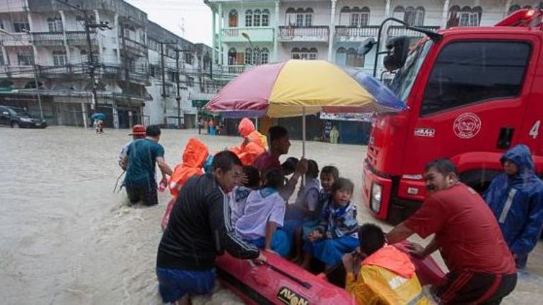
Thailand declares Pattaya a disaster zone following flash floods

Image
© The NationRescue workers use an inflatable boat to take school children home from their flooded school in Rayong province.
Thailand has declared Chon Buri, which includes the popular tourist resort of Pattaya, a disaster zone after it was hit by flash floods this week.

Torrential rain and gusty winds hit the Thai resort for many hours on Wednesday night and Thursday, causing damage to property and chaos to road users, local media said on Friday (Sep 18).

The heavy downpour was a result of a tropical storm Vamco which caused two-metre-high waves and high winds in the Gulf of Thailand.

Pattaya Mayor Ittipol Khunpluem said the disaster declaration would help accommodate state relief and assistance to the area despite the fact that most of the flooding had subsided, the Bangkok Post reported on Friday.


Bizarro Earth

Apocalyptic images show impact of Chile's 8.3 magnitude earthquake

earthquake chile
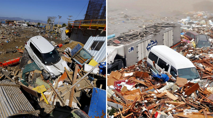
© Reuters (L) A damaged car lies on debris after an earthquake hit areas of central Chile, in Coquimbo city, north of Santiago, Chile, September 17, 2015. (R) Houses and cars are swept out to sea in Kesennuma city March 11, 2011.
Apocalyptic images showing the impact of the 8.3 magnitude earthquake that struck Chile and killed 12 are staggeringly similar to photos from the 2011 Great East Japan Earthquake, which killed almost 16,000.

The quake was felt as far away as Buenos Aires, Argentina. Authorities issued a tsunami alert for Chile's entire Pacific coast.

Question

Dead crows litter streets in Spokane, Washington

Image
© KREMDead crows litter streets in West Valley and Millwood
A viewer e-mailed KREM 2 News on Thursday expressing concern over a large amount of dead birds - crows, to be exact - right near Bessie Street in the neighborhood of West Valley in Spokane.

What is worrying residents like Debbie Lehinger is the fact that they are crows.

"We were always told that if you were to see a dead crow to be concerned and to report it," Lehinger said.

Thursday, the Department of Fish and Wildlife told KREM 2 they are looking into what caused this.


Bizarro Earth

Waves from Chilian earthquake hit Japanese port of Kuji, near site of 2011 earthquake

japan tsunami waves september 2015
© jma.go.jp
Waves triggered by the massive 8.3 magnitude earthquake in Chile and dozens of aftershocks, have reached Japanese coasts, where authorities issued a tsunami advisory.

A wave of some 70 centimeters (28 inches) has been recorded in the port of Kuji, the same area hit by the 2011 disaster, according to Japan's Meteorological Agency. Smaller waves have been detected across the country.

Earlier on Friday, the agency issued a tsunami advisory, expecting waves to hit the Pacific side of Japan from Hokkaido to Okinawa.

Attention

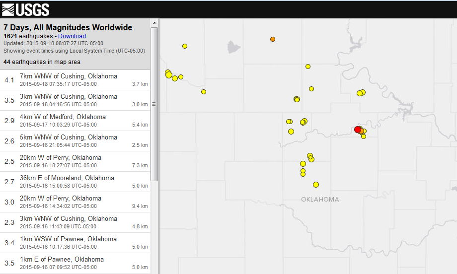
4.1 earthquake registered near Cushing, Oklahoma; state's largest in past 30 days

Image
© U.S. Geological SurveyA 4.1 magnitude earthquake, marked in red on this map, recorded Friday, Sept. 18, 2015 near Cushing, according to the U.S. Geological Survey.
The U.S. Geological Survey recorded a 4.1 earthquake this morning in Oklahoma.

The temblor recorded at about 7:35 a.m. about 4 miles west-northwest of Cushing in Payne County.

The USGS also recorded a 3.5 magnitude quake near Cushing at 4:16 a.m. today.

During the past seven days, the USGS recorded 44 earthquakes in Oklahoma. During the past 30 days, Oklahoma recorded 125 earthquakes of at least 2.5 magnitude.

Today's 4.1 is the largest quake in that timeframe.
The second-largest was a 4.0 recorded Tuesday near Mooreland in Major County.

Comment: See also: Volcanic eruptions and earthquakes increasing across the planet


Attention

3.7 magnitude earthquake recorded near Hawaii Island's Puu Oo Crater

Image
© Hawaiian Volcano Observatory
The Hawaiian Volcano Observatory confirms a 3.7 magnitude earthquake occurred on Hawaii Island Thursday.

The earthquake struck at 12:32 p.m. 6.2 km (3.8 miles) south-southeast of Puu Oo Crater at a depth of 8.1 km (5 miles).

Its location was also 9.9 km (6.1 mi) northeast of Kaena Point, and 10.3 km (6.4 mi) west of Kalapana.

The temblor was reportedly felt in Hilo.

Image

Comment: See also: Volcanic eruptions and earthquakes increasing across the planet