Earth ChangesS


Arrow Down

Sinkhole opens up on farmland in Kybybolite, South Australia

Local Max Schinckel inspects the sinkhole after driving over it in a tractor towing a spray unit.
Driving over a three metre wide and two metre deep sinkhole in a large tractor towing a spray unit is not an ideal situation, but that's the scenario local Max Schinckel found himself in yesterday.

The incident occurred on the property of Kybybolite farmer Andrew Shepherd, who said it was the first sinkhole he had come across on his farm.

"It opened up underneath the tractor and spray unit," Mr Shepherd explained.

"We were very lucky that the weight must have broken the ground, but hadn't actually dropped until the sprayer was basically all the way over it.

"The driver (Max) that was driving the tractor was thrown out of his seat and hit his head on the roof. He stopped to get out and have a look and he found the sinkhole.

"It's something I wasn't expecting, that's for sure."

Fire

Giant wildfire in California imaged from space by NASA satellite

Wildfire from space
The Soberanes fire, currently burning near Monterey, California, was imaged by a NASA satellite on Sunday afternoon, as the blaze continued to swallow up tens of thousands of acres of land.

The fire, which has been burning for a little more than three weeks, had destroyed over 33,000 acres on Saturday (July 30), according to the Los Angeles Times. But in just a few days, the engulfed area has expanded to include 43,400 acres (67.8 square miles or 175.6 square kilometers) according to the state wildfire management agency, Cal Fire.

The image of the fire, trailing white smoke out over the Pacific Ocean, was captured with the Moderate Resolution Imaging Spectroradiometer (MODIS) aboard NASA's Aqua satellite at 4:35 p.m. EDT (20:35 GMT). The red lines on the image show actively burning areas detected by MODIS.

The resolution of the image is 820 feet (250 meters) per pixel, and the image shows an area about 3,730 miles (600 km) long and 260 miles (420 km) wide. A black line representing the California border with Nevada is imposed on the image.
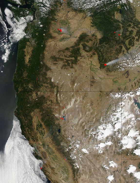
Wildfires (marked in red) in the western United States, seen from space by the Moderate Resolution Imaging Spectroradiometer (MODIS) aboard NASA's Aqua satellite on July 31.

Comment: See also: Wildfires burn across 7 Western states, prompt evacuations


Attention

Up to 1000 dead starfish found on beaches near Fremantle, Western Australia

Dead star fish have washed up at South Beach.
Authorities are investigating reports up to 1000 dead starfish have washed up on beaches near Fremantle since Monday.

Department of Fisheries officers have collected samples of the dead star fish from South Beach and nearby beaches in North Coogee to try and determine what has caused the kill.

The stretch of coast includes a popular dog beach and Port Coogee jetty.

"The samples have been sent to the department's fish health unit for analysis," a Fisheries statement read.

"Results may take some time depending on the tests being undertaken.

"No other dead aquatic animals have been reported or sighted."

Tornado2

Waterspout filmed off Bağırganlı, Turkey

A funnel cloud, possibly a waterspout, was spotted off the northwestern Turkish town of Bağırganlı on the morning of August 3, according to a local resident who shot this video.

Bağırganlı is located on the Black Sea.

This video shows the cloud moving over a headland near Bağırganlı beach before beginning to dissipate.


Tornado2

Tornado hits downtown New Orleans damaging buildings

new orleans tornado damage
© Sophia Germer
The National Weather Service confirmed an EF-0 tornado touched down in the New Orleans area Thursday afternoon.

According to the NWS the tornado had winds of 80 miles per hour. Damage was half a mile in length, and officials said the tornado began at Marias and Annette streets and ended at N. Claiborne and St. Philip Street.

About 3:30 p.m., viewers began sending in pictures of a funnel cloud over the French Quarter area. Shortly after, at the corner of St. Philip and N. Claiborne Avenue, a vacant home collapsed. Officials said two people were brought to the hospital with minor injuries.

Authorities said three buildings collapsed during the severe weather event, all in the Seventh Ward and Treme areas.


Comment: A few weeks ago a huge waterspout formed over Lake Pontchartrain, Louisiana.


Tornado2

Waterspout forms over Lake Manawa, Iowa

Lake Manawar waterspout
© Thomas Baber
A rope tornado was spotted near Lake Manawa Thursday. Videos sent to WOWT 6 News shows the funnel as it formed over the lake before touching down on the water.

It's unclear if the tornado ever left the water, which would make the formation a waterspout. The National Weather Service is expected to give their final assessment Friday.

The rope tornado could be seen from Omaha. WOWT 6 News cameras caught the tornado as it dissipated. Tornado warnings were issued for Mills and Pottawattamie counties; they have since expired.


Comment: Some other waterspouts observed from around the world within the past few weeks include:


Cloud Precipitation

Floods in Sudan kill 76, destroy thousands of houses; the Nile is at its highest levels in more than a century

Sudan flooding
© YouTube/Al Jazeera English (screen capture)
Floods and heavy rain in Sudan have killed 76 people and destroyed thousands of homes in recent days, the interior minister said on Thursday.

Ismat Abdelrahman said 13 of Sudan's 18 provinces had been affected by flooding.

The Nile is at its highest levels in more than a century, swollen by heavy rain in many parts of the East African country, according to the water and irrigation ministry.

Interior ministry statistics showed downpours and flooding had completely destroyed 3,206 houses, and damaged 3,048 others in the eastern province of Kassala, one of the worst hit areas.

Sudan suffers from an underdeveloped infrastructure, particularly in rural areas, which makes it harder to cope with heavy rain and natural disasters.


Cloud Grey

'Chernobyl Sky': Nuclear blast-style cloud appears over Russian city

nuclear cloud
© CENThe weather phenomenon terrified residents.
This gigantic nuclear explosion-style mushroom cloud looming over a Russian city certainly gave residents a fright.

The bizarre phenomenon was dubbed 'Chernobyl Sky' by shocked residents, in reference to the 1986 nuclear catastrophe in Ukraine.

The frightening but harmless cloud over Tyumen, in south central Russia, was later blown off by the wind.

One social media user wrote: "Chernobyl-style sky... Crazy. Like a nuclear explosion happened there or something. Sky was unreal."

Attention

Man attacked by black bear in Warren County, New Jersey

Black bear
Black bear
A New Jersey man is recovering after being attacked by a black bear near his home Wednesday morning.

The man told authorities that he found the bear eating leftover cat food on his porch in Pohatcong Township, Warren County, near the Pennsylvania border.

The man apparently startled the 450-to 500-pound animal, which swiped at him, then ran away into a nearby cornfield.

The man was hospitalized for treatment of lacerations to his arm, Pohatcong Township police said.

The state Department of Environmental Protection's Fish and Wildlife division is working to trap the bear, authorities said.

The man had seen the bear frequently but it had never approached him before, James Kern III, the township's mayor, told NJ.com.

Alarm Clock

Magnitude 6.1 earthquake hits south west of La Quiaca, Argentina

Argentina earthquake
© USGS
Preliminary Earthquake Report

Magnitude: 6.1

Date-Time:
  • 4 Aug 2016 14:15:11 UTC
  • 4 Aug 2016 11:15:11 near epicenter
  • 4 Aug 2016 09:15:11 standard time in your timezone
Location: 22.385S 65.994W

Depth: 258 km

Distances:
  • 48 km (29 mi) NW of Abra Pampa, Argentina
  • 51 km (31 mi) SW of La Quiaca, Argentina
  • 52 km (32 mi) SW of Villazon, Bolivia
  • 107 km (66 mi) SSW of Tupiza, Bolivia
  • 689 km (427 mi) SSE of La Paz, Bolivia