Earth ChangesS


Question

Dead crows litter streets in Spokane, Washington

Image
© KREMDead crows litter streets in West Valley and Millwood
A viewer e-mailed KREM 2 News on Thursday expressing concern over a large amount of dead birds - crows, to be exact - right near Bessie Street in the neighborhood of West Valley in Spokane.

What is worrying residents like Debbie Lehinger is the fact that they are crows.

"We were always told that if you were to see a dead crow to be concerned and to report it," Lehinger said.

Thursday, the Department of Fish and Wildlife told KREM 2 they are looking into what caused this.


Bizarro Earth

Waves from Chilian earthquake hit Japanese port of Kuji, near site of 2011 earthquake

japan tsunami waves september 2015
© jma.go.jp
Waves triggered by the massive 8.3 magnitude earthquake in Chile and dozens of aftershocks, have reached Japanese coasts, where authorities issued a tsunami advisory.

A wave of some 70 centimeters (28 inches) has been recorded in the port of Kuji, the same area hit by the 2011 disaster, according to Japan's Meteorological Agency. Smaller waves have been detected across the country.

Earlier on Friday, the agency issued a tsunami advisory, expecting waves to hit the Pacific side of Japan from Hokkaido to Okinawa.

Attention

4.1 earthquake registered near Cushing, Oklahoma; state's largest in past 30 days

Image
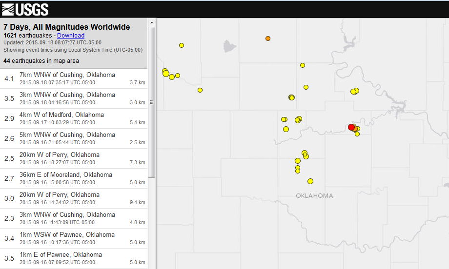
© U.S. Geological SurveyA 4.1 magnitude earthquake, marked in red on this map, recorded Friday, Sept. 18, 2015 near Cushing, according to the U.S. Geological Survey.
The U.S. Geological Survey recorded a 4.1 earthquake this morning in Oklahoma.

The temblor recorded at about 7:35 a.m. about 4 miles west-northwest of Cushing in Payne County.

The USGS also recorded a 3.5 magnitude quake near Cushing at 4:16 a.m. today.

During the past seven days, the USGS recorded 44 earthquakes in Oklahoma. During the past 30 days, Oklahoma recorded 125 earthquakes of at least 2.5 magnitude.

Today's 4.1 is the largest quake in that timeframe.
The second-largest was a 4.0 recorded Tuesday near Mooreland in Major County.

Comment: See also: Volcanic eruptions and earthquakes increasing across the planet


Attention

3.7 magnitude earthquake recorded near Hawaii Island's Puu Oo Crater

Image
© Hawaiian Volcano Observatory
The Hawaiian Volcano Observatory confirms a 3.7 magnitude earthquake occurred on Hawaii Island Thursday.

The earthquake struck at 12:32 p.m. 6.2 km (3.8 miles) south-southeast of Puu Oo Crater at a depth of 8.1 km (5 miles).

Its location was also 9.9 km (6.1 mi) northeast of Kaena Point, and 10.3 km (6.4 mi) west of Kalapana.

The temblor was reportedly felt in Hilo.

Image

Comment: See also: Volcanic eruptions and earthquakes increasing across the planet


Cloud Lightning

Uganda experiences a sharp rise in lightning fatalities

Image
Experts have called for lightning rods, down conductors and other anti-lightning equipment to be installed in schools, as a new book on Lightning Science ranks Uganda highest with the most lightning fatality incidences.

Experts attending the 13 governing council of the NAM S & T Centre at the Commonwealth Resort in Munyonyo, Kampala, expressed that school-going children were the most killed by lightning when it struck, calling for "special anti-lightning gadgets" to be installed in school buildings to carry lightning's electricity safely into the ground.

The NAM S&T is the Centre for Science and Technology of the Non-aligned and Other Developing Countries. It has 47 member representatives from Asia, South America and Africa.

"You hear that lightning has struck: 11 pupils killed, 50 hospitalized. But we have to do something to provide children with safe classrooms they can shelter from lightening," said Prof. Arun P. Kulshreshtha, the NAM S&T director general, when presenting the book with the alarming lightning fatality incidences.

In 2012 — 2013, the country lost over 205 primary school pupils to lightning. The country lost an additional over 160 pupils to lightning in 2014. This year alone, over 30 students were struck by lightning at Iganga. There are other sporadic attacks.

Comment: See also: Sott Exclusive: Shocking weather! Lightning fatalities across the planet on the increase


Attention

Another earthquake hits Chile; 6.3 magnitude tremor near city of Valparaiso

Image
© USGS
A 6.3 magnitude earthquake has struck Chile. The epicenter was located offshore near the city of Valparaíso, according to the US Geological Survey.

The quake, which had a depth of 8.7 kilometers, struck 90 kilometers northwest of Valparaíso, a port city on Chile's coast.

The city is home to 284,000 people, making Greater Valparaíso the second-largest metropolitan area in the country.

It comes after an 8.3 magnitude quake hit off northern Chile on Wedneday evening, killing 10 people. Twenty others were injured, and one million were evacuated from their homes.

The previous quake also affected Valparaíso, with two-meter waves striking the city.

A total of 1,800 people were left without drinking water in the city of Illapel, according to officials. Meanwhile, hundreds of thousands were left without electricity in the worst-affected Coquimbo region.

The homes of 610 people were so severely damaged that they were unable to return by late Thursday afternoon, according to government data. An additional 179 homes were destroyed.

Comment: Mother Nature is mirroring the planet's descent into chaos.


Bizarro Earth

Chile's powerful earthquake partly a consequence of massive nearby quake in 2010

terremoto chile earthquake
© Reuters Rodrigo Garrido
The powerful 8.3 magnitude earthquake that hit Chile overnight was partly a consequence of a massive nearby quake in 2010. But the release of stress from this latest quake does not relieve the risk of an even larger earthquake expected further north. Tsunami warnings have been issued on both sides of the Pacific.

The quake hit at just before 11 pm at a depth of 25 kilometres, off the coast of Coquimbo, 230 kilometres north of Santiago in Chile.

Early reports suggest at least five people have been killed and millions have been evacuated from the nearby Chilean coast, as Tsunami warnings spread around the Pacific. Waves 4.6 metres high were seen hitting in Chile and tsunami warnings are active for California and New Zealand.

Comment: Volcanic eruptions and earthquakes increasing across the planet


Chalkboard

Volcanic eruptions and earthquakes increasing across the planet

Image
If it seems like earthquakes and erupting volcanoes are happening more frequently, that's because they are. Looking at global magnitude six (M6) or greater from 1980 to 1989 there was an average of 108.5 earthquakes per year, from 2000 to 2009 the planet averaged 160.9 earthquakes per year: that is a 38.9% increase of M6+ earthquakes in recent years. Unrest also seems to be growing among the world's super-volcanoes. Iceland (which is home to some of the most dangerous volcanoes on the planet), Santorini in Greece, Uturuncu in Bolivia, the Yellowstone and Long Valley calderas in the U.S., Laguna del Maule in Chile, Italy's Campi Flegrei - almost all of the world's active super-volcanic systems are now exhibiting some signs of inflation, an early indication that pressure is building in these volcanic systems.

When they will erupt is guess work, but in the meantime, activity is growing in Central America's volcanoes such as Costa Rica's Turrialba Volcano, Asia's volcanoes such as Kamchatka, Alaska and Indonesia are also more active. Magma chambers are growing as pressures increase, the numbers of tremors are increasing as are related 'quake-clusters'. If any one of these major volcanic systems has a large scale eruption, it would be a global event. Iceland is considered by many scientists to be the next likely place for a global level volcanic event. The last major event, actually relatively minor, was in 2010 when an Icelandic volcano (Eyjafjallajökull volcano) made headlines around the world by spewing mega-tons of ash into the atmosphere, cancelling and re-routing thousands of flights and costing airlines and passengers more than $7 billion+ in lost revenues.

Bizarro Earth

Flashback Earthquake frequency increasing: Rate of strong quakes doubles in 2014

Earthquakes
© USGSEarthquakes larger than magnitude-7 since 2000.
If you think there have been more earthquakes than usual this year, you're right. A new study finds there were more than twice as many big earthquakes in the first quarter of 2014 as compared with the average since 1979.

"We have recently experienced a period that has had one of the highest rates of great earthquakes ever recorded," said lead study author Tom Parsons, a research geophysicist with the U.S. Geological Survey (USGS) in Menlo Park, California.

But even though the global earthquake rate is on the rise, the number of quakes can still be explained by random chance, said Parsons and co-author Eric Geist, also a USGS researcher. Their findings were published online June 21 in the journal Geophysical Research Letters.

With so many earthquakes rattling the planet in 2014, Parsons actually hoped he might find the opposite - that the increase in big earthquakes comes from one large quake setting off another huge shaker. Earlier research has shown that seismic waves from one earthquake can travel around the world and trigger tiny temblors elsewhere.

Comment: To understand why this is happening, read Earth Changes and the Human-Cosmic Connection. Here's a relevant excerpt:
From 1973 to 1996, earthquake and eruption frequencies were almost stable, increasing only slightly year after year, but from 1996 onwards, an acceleration is noticeable. Volcanic eruptions show an increase from about 59 eruptions per year at the end of the 1990s to roughly 75 eruptions per year in the period 2007 - 2010 (+30%).

Today, the increase in volcanic activity has reached such a level that, by late November 2013, 35 volcanoes were actively erupting , including volcanoes that had been dormant for decades.

It could be argued that the increase in both the frequency and intensity of earthquakes and volcanic eruptions is, at least partly, a result of the slowdown and 'opening up' processes:

1) The Earth's minute slowdown exerts mechanical stress on the crust (compression at low latitudes and extension at high latitude). This stress deforms the crust. This deformation is more pronounced and can even lead to partial ruptures around the weakest spots of the crust, i.e. the fault lines (boundaries between tectonic plates) which are the typical location of seismic and volcanic activity.

2) The mantle has a higher density than the crust and therefore has a higher momentum and won't slow down as fast as the crust. The difference in rotation between the crust and the mantle is equal to the crustal slippage. The fluidity of the mantle enables slippage induced by the different momentum carried by the crust, the upper mantle and the core.

This speed difference can cause friction at the interface between the crust and the mantle. This friction can locally deform the crust and cause earthquakes and eruptions.

3) The decrease in the surface - core E-field reduces the binding force and loosens the tectonic plates relative to each other. The plates are then free to move relative to each other. It is this very relative movement (divergence, convergence or sliding) which is one of the main causes for earthquakes and volcanic eruptions:
[Change] in Earth's speed of rotation would induce changes in the magma tide as it adjusted to the new equator or altered rotational speed. Such changes, however, might not be uniform throughout, owing to a 'drag' factor deep in the magma itself, although, overall, they would certainly impose terrible strains on the lithosphere generally.
4) A final factor involved in earthquakes and volcanic eruptions is electromagnetism:
Some scientists have become aware of a correlation between sunspots and earthquakes and want to use sunspot data to help predict earthquakes. The theory is that an intensification of the magnetic field can cause changes in the geosphere [i.e. crust]. NASA and the European Geosciences Union have already put their stamp of approval on the sunspot hypothesis, which suggests that certain changes in the Sun-Earth environment affect the magnetic field of the Earth, which can then trigger earthquakes in areas prone to them. It is not clear how such a trigger might work.



Cloud Precipitation

Flash floods kill at least five in Yunnan, China

Image
© SCMP PicturesA still from state television footage shows cars washed into trees and street-level wiring by the force of the flooding.
Flash floods have killed at least five people in southwest China and 11 others are missing, state media reported.

The floods were triggered by storms in Huaping county near Lijiang in Yunnan province on Tuesday night and Wednesday morning, the state-run news agency Xinhua reported.

Over 28cm of rain fell during that period, officials said.

Seventy-two homes collapsed during the flooding and nearly 250 were damaged.


Fifteen people were injured, the report said.