Earth ChangesS


Tornado2

Waterspout filmed near Biloxi, Mississippi

waterspout
© WLOX
Residents of Biloxi spotted a water spout in the Mississippi Sound Saturday just after 2:30 p.m. The spout was sighted south of the Beau Rivage.

This is not a tornado, but residents should stay away from the area, if possible, and take caution.


Windsock

At least two dead after devastating 100+ km/h winds blast Ontario and Quebec

Canada windstorm
© Noah Ditkofsky
Half of the country's population was left reeling on Friday as wind gusts in excess of 100 km/h blasted through southern Ontario and southern Quebec, carving a path of destruction along the entirety of the 401 corridor, and leaving at least two dead.

The winds intensified through the afternoon hours, as a rapidly-deepening low pressure system raced into the region, allowing winds from higher than usual in the atmosphere to work their way down to the surface. Known as a 'sting jet' because of the appearance of the associated cloud shape visible on satellite - it looks like a scorpion's tail - these winds are some of the strongest we ever see with storms across North America, aside from those in tornadoes and hurricanes. And they certainly lived up to their stinging moniker on Friday.

At least two fatalities have been reported in the wake of the storm. One person was killed and another hospitalized with life-threatening injuries after a tree fell on two tree removal contractors at 20 Side Road and Fourth Line in the Milton/Halton Hills area.

"One suffered catastrophic injuries at the scene, and was pronounced there," Halton Police Staff Sgt. Jeff Foster told The Weather Network. "The second has been transported to Hamilton General Hospital with life-threatening injuries after the fire department extricated him from the tree that was pinning them down."


Comment: Last month another powerful windstorm left thousands without power in Ontario.


Bizarro Earth

Adapt 2030 Ice Age Report: Are Hawaii eruptions and earthquakes related to cosmic ray increases?

Hawaii lava explosion
© YouTube/Adapt 2030 (screen capture)
With the strongest quake and volcanic eruption in on Hawaii Island, you need to ask yourself it is correlated to solar activity or has something to do with the intensifying grand solar minimum. A 6.9 earthquake and explosive eruption at the Pu O'o vent is rare, but looking at the intensity ramp up of the magnetic wave cancelling on our Sun, well the we get into some interesting similarities. I provide a timeline for the grand solar minimum intensification and incredible images of the lava events on the island.


Comment: Cosmic rays found to be a trigger for explosive volcanic eruptions. Another factor to consider is the slowdown in Earth's rotation:


Boat

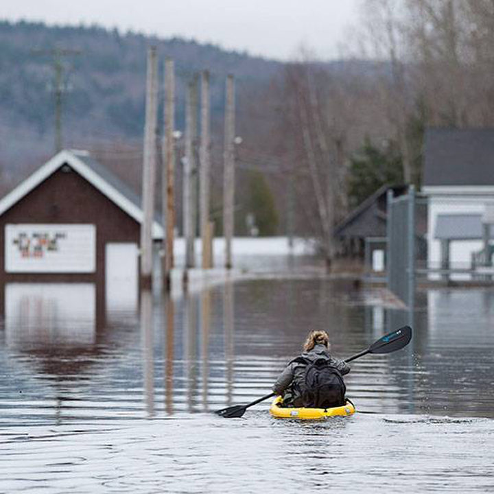
By the numbers: The record-setting flood in New Brunswick, Canada - due to snow melt

Darlings Island, N.B., where the Kennebecasis River has flooded the only road into the community.
© Andrew Vaughan/The Canadian PressDarlings Island, N.B., where the Kennebecasis River has flooded the only road into the community.
Some key numbers Friday from flooded New Brunswick:

306,000: Sandbags distributed so far across the province.

100: Tonnes of sand used so far.


Comment: Part of a report on Floodlist states:
Water levels in rivers began to increase throughout the province from 23 April as a result of continuous snow melt. Flooding has affected areas across New Brunswick over the last 5 days, causing damage to properties and closing 80 roads and bridges, including part of the Trans-Canada highway between Moncton and Fredericton.


Cloud Precipitation

Unexpected flood hits Ankara, Turkey - vehicles float down streets

flood
© IHA
Turkey's capital Ankara was hit Saturday by a sudden flood, which was caused by heavy rainfall in the central Anatolian province.

The flood dragged dozens of vehicles from the streets in Ankara's Mamak district.

Videos showing a man desperately sitting on top of his car, while the flood washed away several vehicles in Mamak's Boğaziçi neighborhood were proof of the unexpected natural disaster.

The man was reportedly later rescued and only slightly injured.


Cloud Lightning

Lightning bolt kills shepherd and over 200 sheep, goats in Pakistan

File photo
A lightning strike Friday killed a shepherd and more than 200 sheep and goats at the "Mosa Ka Mussala hilltop".

According to police, 45-year old shepherded Aleem s/o Kar Khan resident of Meethal village was grazing his flock of 200 sheep and goats in Malian when a lightning strike killed him and over 200 cattle on the spot.

Police said that the lightning strike caused fire that killed the sheep. After the incident locals reached on the spot and recovered the dead body of Aleem Khan and later buried in his native town.

Comment: Elsewhere recently lightning strikes have killed in Tirupati, ( 3 by a single bolt) while 2 children were fatally hit in Hyderabad (both incidents in India) and 2 succumbed in Nepal. Back in Pakistan 5 have died in 3 districts.


Fire

Best of the Web: Hawaii State of Emergency: Small Tsunami Followed Strongest Quake Since 1975 - SIX Fissures Have Opened up, Forcing Evacuations

hawaii lava fissure
A large, 6.9-magnitude quake jolted Hawaii Island on Friday afternoon, just an hour after another sizable quake, amid an ongoing eruption of Kilauea that's triggered mandatory evacuations in Leilani Estates, sent lava spewing into streets and threatened homes.

Six fissures - each several hundred yard longs - have been confirmed in the Puna subdivision, officials say.

The extent of the damage isn't yet known, but officials did say at least two structures were significantly damaged and a number of roads have been covered in lava or severely cracked.

"Everything is still elevated," said Talmadge Magno, administrator of Hawaii County Civil Defense. "It kind of gets you nervous."

The 6.9-magnitude quake, which happened about 12:30 p.m., was the largest in Hawaii since 1975 and generated small tsunami waves around the Big Island. Hawaii County Civil Defense said sea fluctuations ranged from 8 inches in Hilo to 16 inches at Kapoho.


Seismograph

Strong shallow 6.4 magnitude earthquake hits off the Philippines

chart
According to the latest reports by the US Geological Survey, an earthquake measuring 6.4 has struck off the coast of the Philippines.

The tremor was registered at 06:19 UTC (9:19 Moscow time). There are no immediate reports of casualties or damage from the quake, which hit at a depth of 30 km (18 miles), about 50 km north-northwest of Pandan, on the island of Catanduanes, according to the USGS.

No tsunami warnings were issued.

Seismological centers have posted the information about the earthquake on Twitter. Social media users are tweeting alleged photos/videos of the earthquake.


Seismograph

Powerful 6.9 magnitude earthquake, strongest since 1975, hits Hawaii's Big Island near erupting volcano

Hawaii Big Island
© USGS / Reuters
A powerful earthquake measuring magnitude 6.9 has struck just off the Big Island of Hawaii as numerous smaller jolts, including a 5.4 tremor, shook the island in the past hours, amid ongoing volcanic eruption.

The US Geological Survey has upgraded the severity of the earthquake off the Big Island in Hawaii to a 6.9 on the Richter scale, roughly an hour after it was registered. According to the new USGS data, the extremely powerful tremor was registered 16km southwest of Leilani Estates, Hawaii, at a depth of 5.0 km.

The quake struck on the south flank of Kilauea Volcano at 12:33 local time and was followed by several aftershocks, according to the National Weather Service, as eruptions at the volcano continue. No Tsunami warning has been issued.

The tremor was the most powerful of a series of earthquakes that have been rocking the islands over the past days. No Tsunami warnings have been issued after the quake.


Comment: The U.S. Geological Survey said the magnitude-6.9 was the largest Hawaii quake since the 1975 magnitude-7.1 earthquake, which killed two people. The two quakes were centred in almost exactly the same location. See also:


Snowflake

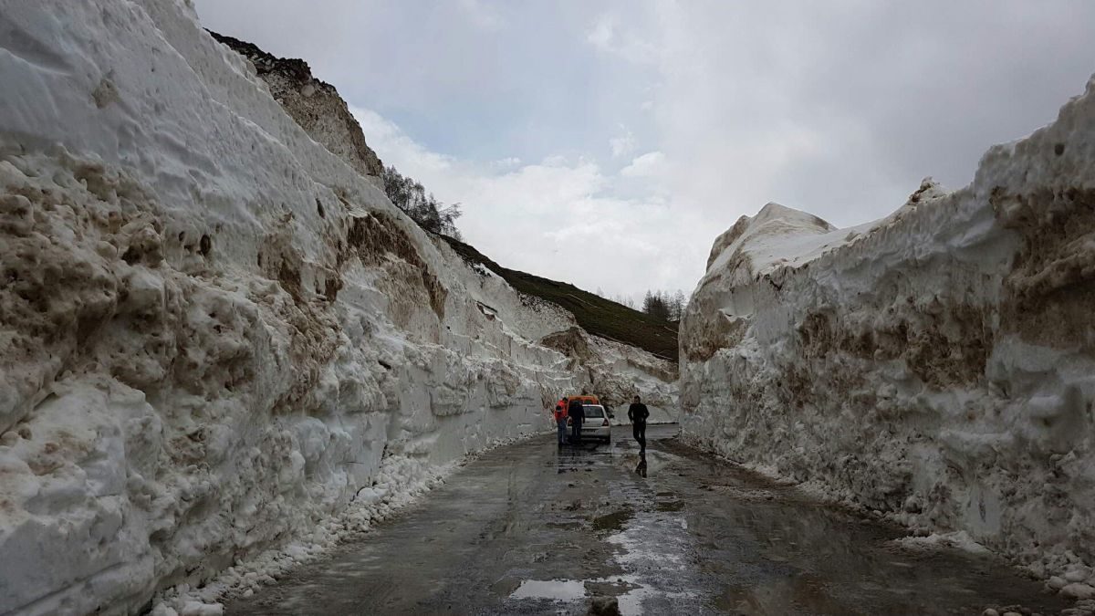
It's May, and roads in Alpine France are buried under 15 meters (50 feet) of snow

Cormet de Roselend,neige
© Jordan Guéant/France 3 AlpesAt the Cormet de Roselend, the road is lined with with 15 metres of snow.
Following late snowfalls, some mountain passes may open 15 days late in Savoie and Haute-Savoie. At Cormet de Roselend, in the Beaufortain, snow removal operations have begun. In some places, the road is covered with 15 metres (50 feet) of snow.

The Savoyard passes are buried under the snow. Early May usually marks the beginning of the reopening of mountain passes to bicycles and cars. This year, after exceptional falls, they are still covered with several meters of snow. They will therefore only be able to open with a fortnight's delay.

At the small Saint-Bernard, we measure up to 6 meters (20 feet) of snow. As for the Iseran and Croix de Fer passes, snow removal will not begin until May 7. At the Galibier Pass, snow removal operations have even been stopped because of the risk of avalanches.

Snow removal in progress 🚜 with 5 to 6 m ❄❄❄ before recovering the Mont-Cenis pass road 🛣
The opening to bikes 🚴♂ and cars 🚗 could be 15 days late #SuperNeige

15 metres (50 feet) of snow at the Cormet de Roselend

Comment: See also: