
Earth ChangesS


Cloud Lightning

One fisherman killed, three others critically injured by lightning strike in Odisha, India

lightning
© 123RF
One fisherman was killed and three others were critically injured today in a lightning strike while they were fishing in Devi river near Astaranga in Odisha's Puri district.

The three critically injured fishermen have been shifted to the nearby Upgraded Public Health Centre (UPHC) at Charichhak.

The deceased fisherman has been identified as Abhay Behera of Balidia village under Astaranga block.

Police have seized Abhay's and have sent it to Charichhak UPHC for post-mortem.

Tragedy struck these fishermen while eight of them were returning home in their boat through Devi river after fishing in the sea.

Camera

More mysterious light flashes recorded over Pacific ocean (Update - Lens flare)

flashing lights over Pacific
© YouTube/LadyInKY (screen capture)
On Monday 3rd and Tuesday 4th October mysterious flashing lights illuminated the skies over the Pacific ocean, captured by the Canada-France-Hawaii Telescope (CFHT) which is located atop the summit of Mauna Kea, Hawaii.

The Cloud Camera is an experimental high sensitivity camera mounted to the catwalk of CFHT. The purpose of the camera is to take pictures of clouds and other weather at night, even on moonless nights. It only operates from sunset to sunrise.

The camera takes a picture every 30 seconds and compiles time-lapse movies from those pictures. As such airplanes appear as streaks and ships appear to move quite quickly.

The following YouTube video from LadyInKY shows the strange phenomena with slow motion included.


The original video can be viewed here courtesy of the CFHT.

Comment: Some other possible plasma type discharge events in recent times include: Update: 4 November 2016

We came across other videos of timelapse from this same camera on the Canada-France-Hawaii Telescope, and they contain the exact same light anomalies. This suggests that the flashes are artifacts of the technology, not something that is actually happening out over the Pacific Ocean.


Tornado1

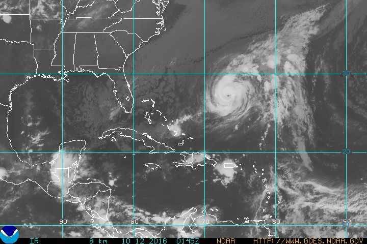
Hurricane Nicole targets Bermuda, may impact Canada

Hurricane Nicole
© National Weather ServiceHurricane Nicole was the only named storm in the Atlantic on Tuesday night.
Nicole continues to strengthen in the central Atlantic Ocean as a category 1 hurricane. All eyes are on Bermuda, with the storm expected to approach the island by Wednesday night. The storm has been slowly moving north since it formed on October 4th.

On October 6, against all odds, with strong wind shear conditions in the area it developed into a Category 1 hurricane and just a day later into stronger Category 2, becoming the first time since 1964 that two hurricanes (Matthew and Nicole) at or above Category 2 existed in the western Atlantic Ocean (65°W) simultaneously.

Soon after, Nicole had again weakened into a tropical storm. However, a large storm system moving over the northeast U.S. is not only helping pull what is left of Matthew away from the east coast, but will also drag Nicole to the north at a greater speed than during these past few days, bringing it directly towards Bermuda.

As a result, the Bermuda Weather Service has issued a hurricane warning for the island.

As of Tuesday afternoon, Nicole is to the south of Bermuda, with wind speeds near 120 km/h. The storm is slowly tracking northwest at roughly 7 km/h.

"Additional strengthening is forecast during the next day or two," according to the NHC.

SOTT Logo Media

SOTT Focus: SOTT Earth Changes Summary - September 2016: Extreme Weather, Planetary Upheaval, Meteor Fireballs

earth changes video september 2016
© Sott.netSuper-typhoon Meranti damages an ancient temple in Taiwan
As the Empire crumples under its own hubris, and as the flames of discontent spread amid rumors of world war, planetary upheaval continues unabated. This month's Hurricane Matthew will probably be remembered as the year's worst storm event in the US (and elsewhere), but in September two other storms, Hermine and Julia - one of them Florida's first hurricane since 2005, and the other the first such storm to ever form directly over the Sunshine State - inundated the coastal US Southeast.

A series of cyclones also brought wave after wave of flooding to southeastern Australia, breaking rainfall records dating back to the country's foundation in the 19th century, and bringing the country as a whole its third wettest winter on record. Meanwhile multiple typhoons in the northwest Pacific battered the Philippines, Taiwan, China, Korea and Japan. 50% stronger today than 40 years ago, the strongest of these cyclonic storms - Category 5 Meranti - was the strongest anywhere in the world so far this year, and second only to 2013's Typhoon Haiyan in the record books.

In addition to the walls of water brought by these large storms, local downbursts brought record-breaking rainfall, causing severe flash-flooding that washed away cars, homes and people in parts of the US, Mexico, Tunisia, Greece, Turkey, Ukraine, India, Indonesia, and China. Oklahoma, which never experienced earthquakes until recently, last month felt its strongest yet. A record-strong earthquake also hit South Korea, while a strong quake in Skopje, Macedonia, damaged buildings and sent residents into a panic.

Multiple volcanic eruptions, mass fish kills, whale beachings and meteor fireball events round off another eventful month of Earth Changes...
Attention

Man survives terrifying black bear attack after hiking in Sierra Madre, California

Black bears
Employing diversionary tactics?
A hiker who was attacked by a bear in the Angeles National Forest north of Sierra Madre on Monday said he is "fortunate" to have survived the terrifying attack.

Dan Richman, 54, spoke exclusively to KTLA late Monday saying he came face to face with two bears while out alone for a short hike, 2 miles up the Mount Wilson Trail.

"All of a sudden I saw this bear standing on its hind legs and I'd never seen a bear in person before, I was pretty freaked out," Richman said.

Thinking the stance was a sign of aggression, Richman backed away from the bear, not realizing a second bear was to his left. That second bear attacked, according to Sierra Madre Police Chief Larry Giannone.

Richman began to yell at the top of his lungs in an attempt to scare the bear away, and it seemed to work. Just as Richman was thinking of running past the bear, it went after him.


Snowflake

Record-breaking snowfall in Saskatchewan triples last year's record

Snowfall in Saskatchewan
A snowfall warning has ended in Saskatoon but remains in place in other parts of Saskatchewan as crews continue to cleanup from a record Oct. 5 snowfall.

According to Environment Canada, 30 centimetres of snow had fallen in Saskatoon as of Thursday afternoon.

At least 17 centimetres fell on Wednesday, unofficially breaking a century old record for that day, when 5.6 centimetres was recorded on Oct. 5, 2016.

Environment Canada stopped measuring snowfall in Saskatoon in 2007, meaning the record cannot officially be broken.

The major low pressure system that brought an early snowfall to many parts of the province is now weakening, with another two to four centimetres expected to fall before tapering off to a few flurries Thursday evening.

Arrow Down

Massive sinkhole appears in Fayetteville, North Carolina

Massive sinkhole off of Bingham Drive in Fayetteville due to Hurricane Matthew.
Pictures don't do it justice. That's the reason many people drove up and walked to Bingham Drive in Fayetteville to see, for themselves, the massive sinkhole in the roadway.

Hurricane Matthew unleashed a fury of wind and water; opening at least, a quarter of a mile hole across the road.

"It looks like something out of a movie," said Fayetteville resident, Laura Dillenger.

Her neighbor, Petra Turner, drove down with her to capture the moment of their cell phones.

"Whoa, whoa. I've never seen anything like that before," Turner exclaimed.

TV crews, dads with their kids, cousins daring each other to get as close to the edge as possible; all in awe of the destruction Matthew left behind.

"I walk this road every day. Tomorrow, my walk will be short," laughed Lawrence Surles, a 33-year resident of Fayetteville.

Arrow Down

Huge sinkhole appears at landfill site in Virginia Beach, Virginia

Sinkhole
© Virginia Beach Public Works
The city landfill is closed until further notice after heavy rain and flooding from Hurricane Matthew created a Grand Canyon of sorts there.

Water filled up a quarter-mile ditch that runs around the site off Centerville Turnpike, then spilled over into a borrow pit and caused "extensive damage," according to the Department of Public Works.

The ditch, which used to be 4 feet deep, now bottoms out at 30 feet.

A concrete-block bathroom was washed away, along with an exit road at the landfill and eight sections of 36-inch pipe. A pump that was in the pit has disappeared. An excavator and a horizontal grinder - two large pieces of construction equipment - are submerged up to their cabs.

Electricity has been shut off at the site, and the city has dammed up the water going into the borrow pit to slow the flow, said Drew Lankford, public works spokesman. Extra pumps have been added to drain the pit. The road will also need to be repaired.

"It's going to be several days before we're up and running," Lankford said.


Cloud Grey

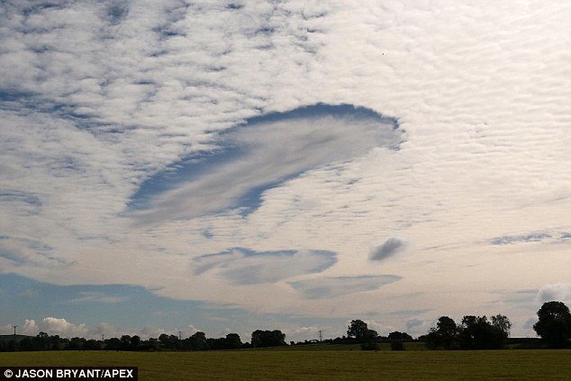
Rare fallstreak or hole punch clouds appear over Somerset, UK

hole-punch cloud over UK
© Jason Bryant/ApexThe rare atmospheric phenomenon is a strange cloud formation, known as fallstreak, or hole-punch clouds

Residents in Somerset were in for a surprise this morning, when they spotted what could easily be mistaken for a UFO in the sky.

The rare atmospheric phenomenon is a strange cloud formation, known as fallstreak, or hole-punch clouds.

Experts say the stunning clouds that look like a brushstrokes are caused by a rare - but rather ordinary - atmospheric occurrence.

The bizarre clouds were snapped over Shepton Mallet, in Somerset.

These unfamiliar clouds form when temperatures are below freezing, but water droplets in the clouds have yet to freeze due to a lack of ice particles.

When ice particles form quickly, it causes a domino effect as the water droplets connect with the crystals, which get heavier and then start to fall all of a sudden - leaving a large hole in the cloud.


Comment: Earlier in the year this rare cloud phenomena appeared over Texas, Louisiana, Mississippi and Alabama.

Other strange cloud anomalies seem to be appearing globally with higher frequency and intensity. Factors which may contribute to these 'strange skies' are atmospheric dust loading from increased comet and volcanic activity and changes in the layers of the atmosphere.

An indicator of this dust loading is the intensification of noctilucent clouds we are observing. As explained in Pierre Lescaudron's book, Earth Changes and the Human-Cosmic Connection:
The increase in noctilucent clouds is one of the effects - among others - of increased dust concentration in the atmosphere in general, and in the upper atmosphere in particular. We suspect that most of this atmospheric dust is of cometary origin, while some of it may be due to the recent increase in volcanic activity.
See also: Chemtrails? Contrails? Strange skies


Cloud Precipitation

Britain facing a "winter of flooding" with storms and heavy rain predicted

Flooding
© Getty / stock image
Britain is facing a "winter of flooding" with high winds and heavy rain threatening to batter the country over the next few months. Stormy weather is due to hit the UK later this month and forecasters have warned of the first named storm of the season within weeks. They say Scotland and the north will be in the firing line for the severe wet weather this winter.

AccuWeather senior meteorologist Alan Reppert said the entire country should prepare for "damaging winds" through winter. He warned: "A stormy weather pattern will set in before wintertime with active weather during the second half of October across the United Kingdom." Mr Reppert added: "At least one named windstorm is expected during this time before a lull in November. However, storm systems may still bring locally heavy rainfall at times during the month. The most active period of weather will be during the official winter months from December through February."

Brits have been told to expect a choppy run up to Christmas with wet and windy weather stretching through the New Year.