A storm spinning over Virginia has a tropical depression type of feel to it. This is what led to the incredible storms on the Delmarva Saturday. We had evening views from Ocean City, which got their flooding at night. Consider that 4-8 inches of rain fell on the Delmarva Saturday, and that could repeat for us today.
While the original system is well inland, a new wave of Low Pressure has formed near the coast. Combine that with High Pressure in New England, and the funneling of very humid winds off of the Atlantic Ocean is helping to generate widespread storms. Enough circulation in the atmosphere is helping a few of these storms to spin up rapidly.
The first Tornado Warning was issued in Charles County (southern MD) just before noon until 12:30pm. The video clip on the left confirms the spotted touchdown over Cobb Island and Swan Point. The only report was that this started as a water spout and moved onshore. No damage report at this time. Anytime there is a tornado in that region, it stirs up memories of the La Plata tornado 10 years ago in 2002.
A second possible Tornado Warning was issued for Baltimore County for a different cell until 1:15pm. My friend Craig Dlin shared some photos of the flooding on Reisterstown Rd in Owings Mills from that cell. Rainfall has been between 2-4 inches in a narrow band from central Baltimore County through Anne Arundel County.
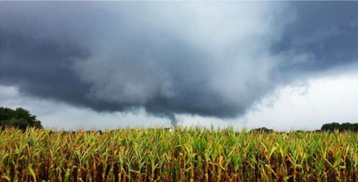
More flooding on the Eastern Shore has a Flash Flood Warning until the evening parts of Tallbot, Caroline, and Queen Anne's Counties. This region may have had an unreported twister. The image captured in the field by Mark Dignen does show the sign of a lowering, circulating base.


Reader Comments
to our Newsletter