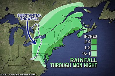
A storm delivering needed rain to the Atlantic Seaboard will have many faces ranging from urban flooding, to strong winds, unusual cold, heavy snow and power outages into today. A strengthening storm is rolling up the Atlantic Coast with drenching rain.
For many areas, aside from spoiling outdoor plans, the rain is greatly needed with some locations from Washington, D.C. to Boston experiencing a rainfall deficit of 6 inches since March 1. The storm already has or will deliver a thorough soaking. However, the storm will bring problems as well. Enough rain can fall in urban areas to overwhelm storm drains and catch basins from the Delmarva to Maine.
© AccuWeather
New England will be hit the hardest during the morning rush today. Expect travel delays. The storm will also pack gusty winds. The worst of the wind on the front side of the storm will take aim from New York City on north and east.
The strength of the wind from the east and southeast in these areas can knock down tree limbs and cause coastal flooding at high tide. Since the storm is near the coast and will hook inland, the worst seas will be in coastal waters.
© AccuWeather
Around New York City the highest tide levels (combination of storm surge and astronomical tides) will occur into the wee hours of the morning. Around Providence, the worst is likely during midday hours. Around Boston the highest water levels are likely from lunchtime into the early afternoon.
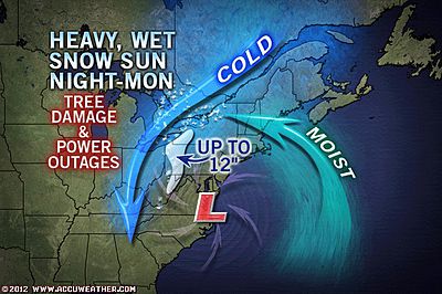
Tides can be briefly 1.5 to 3.0 feet above published values, depending on local funneling effects. On the storm's back side, gusty winds will funnel cold air in across the Great Lakes, Ohio Valley and southern Appalachians. It is conceivable winds are strong enough in this sector as well to down trees even without snowfall.
For portions of the central Appalachians, this will seem like the second of two bookend snowstorms in "a year without a winter." From the West Virginia mountains to western Pennsylvania, western upstate New York, part of southern Ontario and western Quebec the right conditions will come together to unload heavy wet snow.
In the mountains, such as part of the I-80 corridor, the snow will stick to some of the roads. The greatest accumulation will be on non-paved surfaces in the higher elevations. However, some snow is bound to stick to grassy areas, hills and tree tops in this swath even out of the mountains.
For areas farther east, the storm will first bring too much warm air, then later too much dry air for snow. Power outages related to downed trees from heavy snow during the storm, then wind tossing following the storm are a concern not only in the central Appalachians, but also as well as the metro areas of Pittsburgh, Youngstown, Erie, Buffalo and Toronto. Problems could reach into the eastern suburbs of Cleveland and as far east as Rochester.
The storm will drive cold air well into the South and to the East Coast during the first half of the week. The cold air will be accompanied by wind, adding to the discomfort.
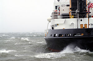
© UnknownThe storm will bring a period of rough seas to coastal areas, which is rather uncharacteristic for the second half of April.


Reader Comments
to our Newsletter