© AccuWeather
Major Hurricane Bud continues to strengthen and will threaten western Mexico with flooding rainfall this week.
Bud became the second major hurricane of the season in the East Pacific basin on Monday morning, less than a week since former Hurricane Aletta passed over similar areas.
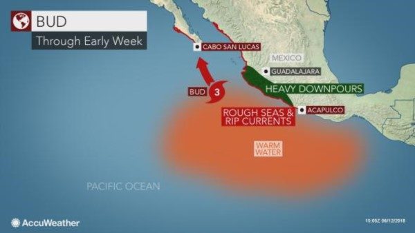
Bud will track toward the north-northwest the next several days, keeping the powerful tropical system off the coast of Mexico. However, it will track close enough to bring heavy rainfall to parts of the country.
"Bud is moving within an environment of low wind shear, moist air and warm ocean water," said AccuWeather Hurricane Expert Dan Kottlowski.
These conditions allowed Bud to reach
Category 4 status at peak strength on Tuesday morning with sustained winds of 130 mph (209 kp/h) before beginning to weaken later in the day.
A northwest track through midweek will keep the most powerful winds associated with Bud well offshore, but widespread showers and thunderstorms across
southern Michoacan, Colima and Jalisco will raise the threat for flooding and mudslides.Rainfall amounts of 100-200 mm (4-8 inches) are expected with local amounts up to 300 mm (12 inches) through Wednesday.
Small rivers and streams may quickly rise out of their banks and turn into deadly torrents.
Flooded streams and rivers may wash out roadways, isolating communities for several days or longer.
Rough seas and dangerous
rip currents will once again threaten beaches from Acapulco to Mazatlan, as well as southern Baja California.Boaters and bathers should use extreme caution and heed all small craft and beach advisories as they are issued.
If caught in a rip current, it is best to swim parallel to shore until free of its influence.
Instead of curving westward like Aletta, Bud will continue its northward track toward the Baja Peninsula of Mexico later this week.
"This track will take Bud over cooler waters, causing it to continue weakening over the next few days," said Kottlowski.
Relatively slow movement over this cooler water will cause Bud to weaken into a tropical storm prior to reaching Baja California late Thursday into Thursday night.
As Bud approaches Baja California, there will be an increase in showers and thunderstorms as early as Wednesday afternoon in the far south, including Cabo San Lucas.
Showers and thunderstorms will spread across much of Baja California and neighboring parts of northwestern Mexico from Thursday into the weekend. There will be an increased risk for flash flooding and mudslides in southern Baja California and northwestern Mexico.
Despite weakening, Bud may still produce some locally damaging winds in southern Baja California as it approaches or makes landfall later this week.
Damage to trees and power outages are the most likely impacts. Some locations could be without power for multiple days in the hardest-hit areas.

© AccuWeather
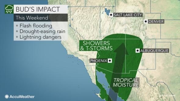
Some moisture will also be drawn northward into the United States. Such moisture would be
beneficial to drought-stricken areas of the southwestern U.S., but could also create flash flooding issues if there is too much rain too quickly.
AccuWeather Meteorologists anticipate that the East Pacific basin will remain active this season with an above-normal number of tropical cyclones forecast.


Comment: This is no good news for western Mexico. The state of Jalisco, in particular, which will be affected by Bud, has just been hit by flash floods. See here for some dramatic pictures and footage.