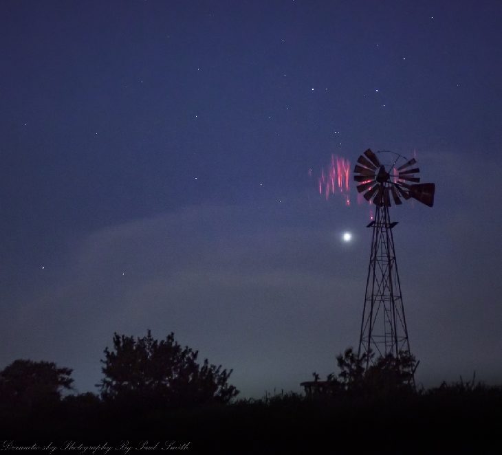
Oklahoma is a good place to see sprites. "I photograph them often," says Paul Smith of Edmond OK. "Here are some examples from May 30th flashing above fast-moving storms in the Oklahoma panhandle."
"Venus is the bright 'star' just behind the windmill," he adds.
Oklahoma is the epicenter of a region that we call "Sprite Alley," a corridor stretching across the US Great Plains where intense thunderstorms produce lots of upward directed lightning--a.k.a. "sprites."
"I have been recording sprites since last summer when I accidentally caught a few during the Perseid meteor shower," says Smith. "I now have a couple of hundred events on camera and I am out almost every night there are storms in my vicinity."
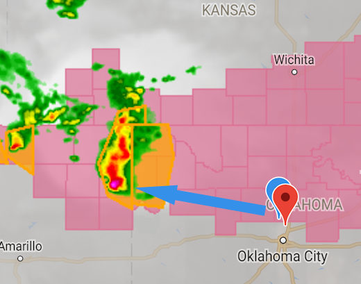
The blue pushpin in the satellite weather map, above, shows Smith's location. The blue arrow points to the storm cell that produced the sprites.
People have been seeing sprites since at least the 19th century, but those early reports were often met with skepticism. Sprites entered the mainstream in 1989 when researchers from the University of Minnesota finally captured them on film. Subsequent video footage from the space shuttle cemented their status as an authentic physical phenomenon.
In recent years, citizen scientists have been photographing sprites in record numbers. But why? It could be a result of raised awareness. More photographers know about sprites, so naturally more sprite photos are taken. There might also be a real increase in sprite activity. Some researchers think that sprites are linked to cosmic rays: Subatomic particles from deep space strike the top of Earth's atmosphere, producing secondary electrons that trigger the upward bolts. Indeed, cosmic rays are now intensifying due to the decline of the solar cycle.
Comment: The latter explanation is more likely, in tandem with a variety of other changes: Photographer captures yet another photo of 'rare' red sprites - in skies above Oklahoma
It all adds up to more sprites over Oklahoma. More examples may be found on Paul Smith's Facebook page.
Steve spotted in Canada
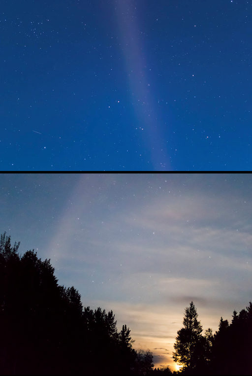
On May 31st, as Earth was entering a stream of high-speed solar wind, hot currents of plasma began to flow through the upper atmosphere over North America. When this happens, STEVE appears. Matthew Wheeler saw the purple ribbon of light from Robson Valley, British Columbia:
"It was visible to the naked eye despite bright moonlight," says Wheeler, who, on darker nights, has taken some incredible videos of the STEVE phenomenon.
This particular stream of solar wind has a knack for summoning STEVE. One solar rotation ago, in early May, the same stream lashed Earth's magnetic field. STEVE was then sighted not only in Canada (its usual habitat) but also in multiple US states. Bright moonlight this time is making the mysterious ribbon more difficult to see, and will probably reduce the number of sightings.
Noctilucent clouds seen from the ground
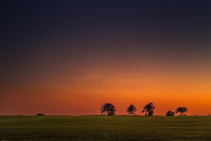
Only a few days after NASA's AIM spacecraft began to see noctilucent clouds (NLCs) forming over Earth's northern hemisphere, people on the ground are beginning to see them, too. "They are back!" reports Ruslan Merzlyakov of Hjørring, Denmark. "I saw the NLCs during the early hours of May 31st." In this picture, they are silvery ripples beaming through the orange glow of sunrise:
Early-season sightings of NLCs are always like this--faint and silvery, with a rippling structure that distinguishes them from ordinary clouds. They may not remain faint for long. Previous data from AIM have shown that NLCs are like a great "geophysical light bulb." They turn on every year in late spring, reaching almost full intensity over a period of 5 to 10 days. Soon the silvery ripples Merzlyakov spotted should intensify and spread, forming electric-blue waves that glow deep into the night.
What are NLCs? You can think of them as frosted meteoroids. Noctilucent clouds form when summertime wisps of water vapor waft up to the top of Earth's atmosphere and crystallize around specks of meteor smoke. The resulting swarms of tiny ice crystals glow electric blue when struck by high altitude sunlight.
Colorful clouds pile above Alberto
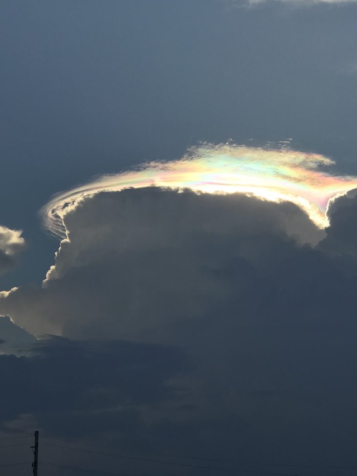
Yesterday, May 30th, tropical depression Alberto was spending the last of its strength over Illinois when Chris Moore in the town of Streator looked up at the sky. "I caught these spectacular rainbow-colored rings swirling around a cloud bank on the western edge of the storm," he says. "The setting sun lit up the wispy clouds from behind."
These are pileus clouds, and while they may resemble rainbows, they form in a completely different way. To make a pileus cloud, a cumulus cloud must first boil upward, pushing layers of moist air above it where the layers cool and condense to form cloud caps ('pileus'). Because pileus clouds form very quickly, their internal water droplets tend to be all the same size--the perfect condition for iridescence. Uniform droplets diffract passing sunlight into vivid pastel hues.
Normally pileus clouds appear on warm summer afternoons when the landscape is festooned with rising cumulous towers. In this case, however, Alberto created the conditions for a late-spring display.


Comment: It wasn't so long ago that these strange sights in the sky were considered a rarity, now they're being documented daily. And it's not just up above that we're paying witness to the great changes afoot, it's below too:
- GARGANTUAN sinkhole swallows several cars and building is evacuated in Rome (VIDEO)
- Monster cracks appear in the ground after landslide and heavy rains destroy over 100 buildings in Cusco, Peru (PHOTOS, VIDEO)
- Erratic seasons and extreme weather devastating crops around the world
- Researchers discover 900 new methane seeps off the Oregon coast near the Cascadia Subduction Zone
- Rare green flash sunset photographed flickering into even rarer blue in Norway
- Sunlight drips through clouds and strange arc of dotted light spotted in sky at Missouri River (PHOTOS)
Also check out SOTT's monthly documentary: SOTT Earth Changes Summary - April 2018: Extreme Weather, Planetary Upheaval, Meteor Fireballs