With the autumn season now here, the strength and number of powerful storm systems will be on the increase.
This week will feature two powerful autumn storm systems, one through the middle of the week and another towards the end of the week.
As the jet stream strengthens and dips farther south, the clashes between warm and cold air become more frequent. As a result, the potency of low pressure systems increase.
Tens of millions will be impacted by these storm systems this week, with the risks ranging a wide spectrum.
First Storm System Targets Central U.S.The first storm will take shape across the High Plains and into the central portion of the United States as the
energy that brought flooding downpours and severe weather to the Southwest shifts to the northeast.
Folks from eastern Montana to Wisconsin and south to Oklahoma will be impacted by this storm as it passes through the Plains.
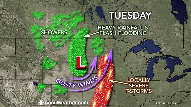
Windswept rain will blast areas on the north and western side of this system, mainly affecting Montana, Wyoming, and the Dakotas Tuesday through Wednesday.
The risk for flooding will highlight these areas, especially in the Black Hills where terrain will increase rain intensity. Wind speeds of 30 to 40 mph with higher gusts will also accompany the rain.
Motorists caught out in this will face lowered visibility and hazardous driving conditions. Slower commute times and delays should be anticipated.
Those in high profiled vehicles such as vans and tractor trailers will want to use caution when traveling on open roadways as strong winds could topple them.
Deck furniture could be tossed around and may need to be tied down or sheltered.
Another area of concern on Tuesday will be across the central Plains where gusty thunderstorms will ignite along a cold front.
Cities such as Sioux Falls, South Dakota; Omaha, Nebraska; Kansas City Missouri; and Wichita, Kansas will be at risk for damaging winds and torrential downpours.
Storms may ignite Wednesday afternoon and evening across Missouri, Kansas, and Oklahoma. These storms will again threaten people with damaging winds and torrential downpours.
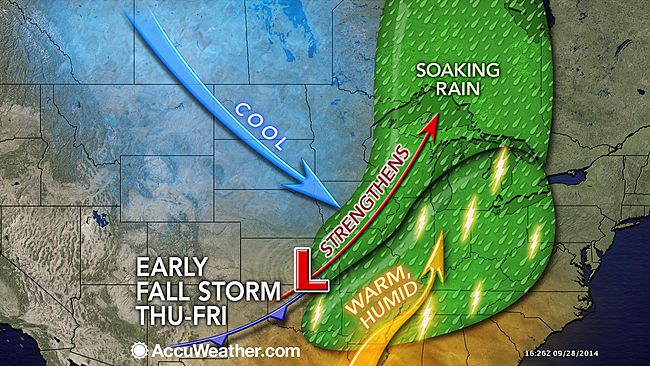
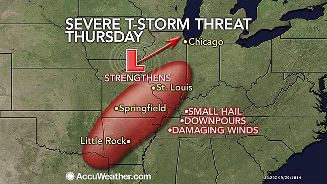
Second Powerful Storm System to Slam Great Lakes, Ohio ValleyFeeding off some of the energy from the first storm system, another potent storm is expected to develop across the central Mississippi Valley towards the end of the week.
A track through the Great Lakes and into Ontario is likely as the week draws to an end and a potent cold front will trail to the south.
Damaging storms could ignite along this front and target several major cities for Thursday and Friday, including Chicago, St. Louis, Indianapolis, Memphis, Nashville, Detroit, Cleveland, and Pittsburgh.
However, the exact timing and severity of these storms is still up for debate and folks in these areas will want to keep checking back to AccuWeather.com.
Windy conditions may also develop in the wake of this system and may bring rough water to the western Great Lakes. Boaters will want to keep an eye on the development of this storm.
The front will progress into the Northeast into the weekend, spreading rain and wind over the region and putting outdoor activities at risk.


Reader Comments
to our Newsletter