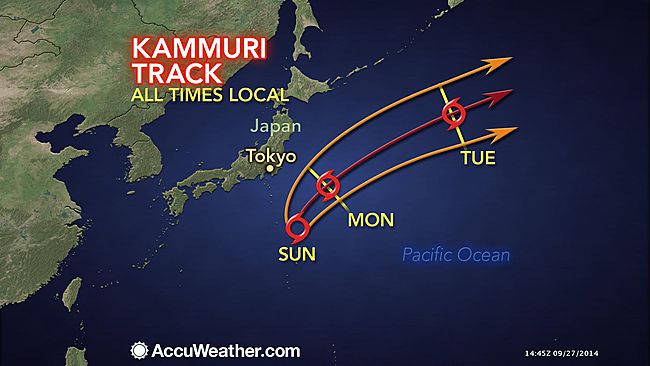
Tropical Storm Kammuri has gradually become more organized during the past several days. The system began early this past week as a weak area of low pressure that produced showers and thunderstorms near the Mariana Islands.
Kammuri is now located to the southeast of Japan and is generally moving to the north. A turn to the northeast is expected Sunday into Monday which will cause the storm to miss Japan. However, Kammuri will still pass close enough to bring a few impacts to the country.
The key factor in the movement of the tropical storm is a fast-moving trough of low pressure that AccuWeather.com meteorologists have been tracking since it was located over 1,000 miles away across Siberia.
Now that this trough is located across eastern Asia, Tropical Storm Kammuri is feeling the effects as the storm is being pulled to the north and eventually the northeast.
As the trough of low pressure continues to interact with Kammuri, effects will become even greater which will cause Kammuri to accelerate to the northeast across the northern Pacific early this coming week.
Before then, Kammuri will pass close enough to Japan that a few outer bands of showers will affect Chiba and Ibaraki prefectures, both located to the east of Tokyo.
On Sunday, the outer fringes of the storm will bring a few showers and a gusty wind to this area. Neither the rainfall nor the wind will cause significant impacts, but they will bring an inconvenience to outdoor plans. Wind gusts along the coast may reach 70 kph (45 mph).
The greatest impact will likely be rough surf and the threat for rip currents along eastern facing coasts creating dangerous conditions for swimmers and boaters. Offshore wave heights are expected to be in excess of 4 meters (12 feet).
As Kammuri accelerates into the northern Pacific early this coming week and weakens, attention will turn back to the to near the Marshal Islands as AccuWeather.com meteorologists monitor for additional tropical development later this week.

Reader Comments
to our Newsletter