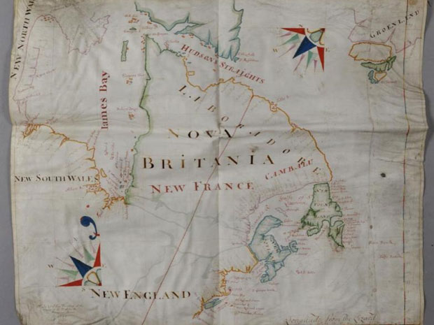
A long-lost treasure of Canadian history - a one-of-a-kind, 17th century map of the country, hand-drawn by the leading English cartographer of the era - has been discovered under a thick layer of dust in the utility room of an old house in rural Scotland.
The previously unknown depiction of New France and "Nova Britania" covers an area stretching from modern-day Manitoba on the western shore of Hudson Bay to "Labradore," "New Scotland" (Nova Scotia) and the island of "New Found Land" in the east.
The southern part of Baffin Island appears at the upper edge of the map, with the fledgling American colonies of New England shown to the south.
Described by the British auction house that found the map as "remarkably well preserved," the 311-year-old relic is made of vellum, a specially prepared sheet of animal skin - typically from sheep - that was used by European map-makers in the 1600s to produce durable illustrations of the new lands being discovered across the Atlantic Ocean.
Such originals were usually used to create the etchings for published maps or atlases, but the one found in Scotland appears to have been specially commissioned for a commercial client and never copied in print.
The map is dated 1699 and signed by John Thornton, a renowned figure in 17th century cartography known to have been hired to produced maps and marine charts for the Hudson's Bay Company and East India Company, the trading firms that served as the commercial spearhead of British imperialism during the golden age of European exploration.
The unique artifact is to be sold in January, expected to fetch as much as $125,000, according to the British auction house Lawrence Fine Art. Curators from the Somerset-based firm discovered the map while evaluating items for an estate sale following the death earlier this year of the owner of a country home in Aberdeenshire.
The map had apparently been stored undetected on a shelf in the Scottish house - "beside some water tanks" - for generations, the auction house said in a statement announcing the sale. "But its potential significance was recognized immediately."
Two maps by Mr. Thornton, who lived from 1641 to 1708, are highlighted in B.C. author Derek Hayes' definitive Historical Atlas of Canada. Hayes notes that Thornton and his son, Samuel, played a key role in charting navigation routes and coastal forts for the Hudson's Bay Company, which received its royal charter in 1670 and was soon battling French rivals for control of the North American fur trade.
"Other maps were produced for the company by the Thorntons," Mr. Hayes writes, "but few have survived."
He says a Thornton map made in 1709 for the firm - which closely resembles the map found in Scotland - is "the only one now in the Hudson's Bay Company archives."
The 1699 map is described as "meticulously coloured" and includes a trademark Thornton compass rose featuring blue, green and red points of direction.
"Map specialists at the British Library have suggested that the map might have been a special commission for a patron on account of the considerable detail given to small settlements on the Newfoundland coast, implying an interest in the local fishing business," the auction house said. "Its surprising appearance in a Scottish country house is explained by the business interests of the late vendor's father, Harold Fortington, who had links with Canada and North America before the Second World War."
The Jan. 17 sale of the 1699 map, which measures 68 by 80 centimetres, "is expected to attract international interest," the auction house said.


Reader Comments
to our Newsletter