Reinforcing shots of frigid air from Canada will continue to spill into the East into next week. By Thanksgiving Day, temperatures will finally rebound a little closer to normal.
The
Midwest Regional News story reports that a weak Alberta Clipper moving into the Upper Midwest today will spread the next wave of arctic air into the East by this weekend, while sparking the next round of lake-effect snow to the lee of the Great Lakes.
Today, residents in the East woke to sub-freezing temperatures across the region. According to the
East Regional News story, lows early this morning plummeted into the 20s across a good portion of the eastern third of the nation.

© AccuWeather
High pressure moving into the South helped to clear the sky, allowing portions of northwestern Florida to be gripped by a hard freeze. Tallahassee dipped below the record cold low of 29 degrees set in 1990.
The Severe Weather Center has a list of freeze-related watches and warnings in effect in the South.
Highs will be as much as 20 degrees below normal today throughout most of the East, challenging even more record cold high temperatures. Gusty winds will add to the chill, with RealFeel® temperatures that will feel much colder than the actual readings.
The high forecast today in New York City is 38 degrees, the first time since February 29 that the high in Manhattan will fail to reach 40 degrees.
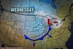
Meanwhile, the coldest air mass of the season is yet to come. The cold front associated with the clipper in the Midwest will mark the leading edge of this next cold shot.
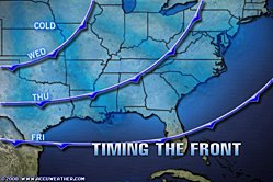
Temperatures on Thursday in the Upper Midwest, an area sometimes referred to as the gateway to cold air from Canada, will fail to climb out of the 20s as the core of cold far behind the front surges toward the Midwest and the Deep South.

© AccuWeather
By Friday, the front will advance into central Florida and the cold air will flood across the eastern third of the county. The cold will continue into early next week, making it feel more like the week of Christmas rather than Thanksgiving.
The lake-effect snow around the Great Lakes will add to the feeling of winter. Snow squalls develop through Sunday in areas downwind of the lakes, with the heaviest snowfall expected in areas immediately to the lee of the lakes.
The cold air will ease and highs will be closer to normal by next Wednesday, which is considered to be the busiest travel day of the year.
Many American families will be traveling next week, despite the tough economic times. The American Automobile Association on Tuesday estimated that roughly 41 million Americans will travel 50 miles or more from home this Thanksgiving holiday weekend.
The AAA estimate is down 1.4 percent from the total of 41.6 million travelers a year ago. This is the first decline in Thanksgiving holiday travel since 2002 and is the fourth consecutive travel holiday this year with a year-to-year decline in the number of travelers.


Reader Comments
to our Newsletter