|
| ©KOMO News |
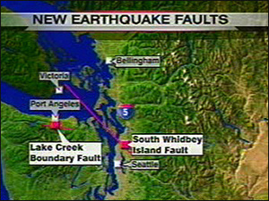
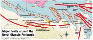
The U.S. Geological Survey released new seismic hazard maps this week that focused on quake faults across the nation, including the Lake Creek-Boundary Creek fault that runs from central to eastern Clallam County - from roughly 15 miles west of the Elwha River to just past Siebert Creek.
It is capable of producing a magnitude-6.79 earthquake and has been active over the past several thousand years.
It was studied in detail by scientists in 2006 and is included for the first time in the new seismic hazard maps.

|
| ©Peninsula Daily News |
A quake on this fault would be similar to the February 2001 Nisqually earthquake, which struck northeast of Olympia.
It had a magnitude-6.8 that caused more that $100 million in property damage and shifted the dome over the Legislative Building.
Subduction quake
Scientists also revised their estimates about the Cascadia Subduction Zone, where the Juan de Fuca and North America tectonic plates collide in an area off the coast between Vancouver Island and Northern California.
The northern part of the fault runs off the Olympic Peninsula coast.
New studies indicate the subduction zone is more likely to experience one great 9.0 quake that will completely rupture the fault, rather than the other possibility of a series of smaller, but still major, quakes in the 8.0 range.
Either way, subduction quakes could cause catastrophic tsunamis that would sweep over Neah Bay, LaPush and other coastal locations.
But earthquake experts say it takes about 500 years to build the pressure necessary for a 9.0 quake in the subduction zone.
Geological records suggest the last such quake was in 1700, meaning that the next big one could be 192 years away.
"Don't hold us to that," said Craig Weaver, the Pacific Northwest earthquake coordinator for the USGS. "But that is the math."
Using new models produced by the Japanese, Mark Petersen, chief of the USGS National Seismic Mapping Project in Golden, Colo., said a major subduction zone earthquake also could produce more ground motion than originally thought.
"This is very complicated, but the risks are slightly higher than before," he said.
Richter readings
On the Richter scale, every increase of one number means a tenfold increase in magnitude. Thus a reading of 7.5 reflects an earthquake 10 times stronger than one of 6.5.
An earthquake of 3 on the Richter scale can cause slight damage in a local area, 4 can cause moderate damage, 5 considerable damage, and 6 can be severe.
A 7 reading is a "major" quake, capable of widespread heavy damage, and 8 and above is a "great" quake, capable of tremendous damage.
The new seismic hazard maps also focus on the South Whidbey Island fault, which extends south of Whidbey Island.
Scientists say it is longer than previously thought, cutting through Seattle's heavily populated northern suburbs to Woodinville and perhaps as far as North Bend.
Weaver said this fault has the highest hazard of any fault in the state - and could produce a magnitude-7.5 earthquake.
He said there have been at least four quakes along this fault in the past 16,000 years.
"It cuts right through one of the most populated areas along Puget Sound," Weaver said.
Border fault
Another fault factored into the new maps is about 25 miles from Bellingham, not far from the Canadian border.
Known as the Boulder Creek fault, it is thought to be capable of producing a magnitude-6.8 earthquake and has been active over the past several thousand years.
The main danger is to Abbotsford, British Columbia, a city of about 175,000, said Craig Weaver, the Pacific Northwest earthquake coordinator for the USGS.
"It wouldn't have a lot of impact in Bellingham, but would have a lot of consequence for our friends in B.C.," Weaver said.
Quake hazards
The new National Seismic Hazard Maps - a series of maps and data sets that project the ground shaking that might happen at points throughout the country - shows much of the United States is on shaky ground, with 46 states facing serious seismic threats.
The new maps also provide further evidence of the high earthquake hazard in Washington state, among the highest in the nation.
Western Washington and Oregon are laced with 100 or so known faults, and no one is sure how many more crisscross the region.
More than 1,000 earthquakes occur in the state every year, including a magnitude-3.4 quake in Snohomish on Monday.
USGS last published nationwide hazard maps in 2002 and 1996.
The new maps are being released at the same time as a national revision of the model building codes used by state and local government so that buildings, bridges, highways and utilities can resist earthquake damage.
Insurance companies use the data to set rates in some places.
Engineers use the maps to forecast landslides and the stability of hillsides.
Federal environmental regulators use the maps to ensure waste-treatment facilities will hold up.
Emergency planners use the information to decide how to allocate money for education and preparedness.
Good news
The new maps also contain some good news for Washington residents.
Scientists now estimate that potential ground motion in the Western United States is 30 percent lower than they previously thought for the kind of quakes caused by long-period seismic waves that would affect taller, multistory buildings.
Scientists developed these new estimates by using new ground-motion predicting models created after looking at shaking records from 173 global shallow crustal earthquakes.
As part of a statewide earthquake drill Tuesday, Gov. Chris Gregoire urged Washingtonians to prepare to be self-sufficient for at least three days following a disaster.
The USGS has prepared a pamphlet called "The Seven Steps to Earthquake Preparedness." Go to www.earthquakecountry.info and click on "Seven Steps" on the left.
The new seismic hazard maps can be seen at earthquake.usgs.gov/research/hazmaps/.


Reader Comments
to our Newsletter